|
|
|
| Introduction | |
| Methods | |
| Sedimentary Environments | |
| Implications | |
| Acknowledgments | |
| References | |
| Figure Captions | |
| Digital Data and Metadata | |
| Back to Table of Contents | |
|
|
|

Chapter 3
|
|
|
| Introduction | |
| Methods | |
| Sedimentary Environments | |
| Implications | |
| Acknowledgments | |
| References | |
| Figure Captions | |
| Digital Data and Metadata | |
| Back to Table of Contents | |
|
|
|
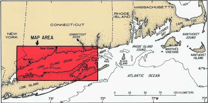 Long
Island Sound is one of the largest estuaries along the Atlantic coast of
the United States (Fig. 1).
It is a glacially produced, semi-enclosed, northeast-southwest-trending
embayment, which is 150 km long and 30 km across at its widest point.
Its mean water depth is approximately 24 m. The eastern end of the
Sound opens to the Atlantic Ocean through several large passages between
islands (Fig. 1), whereas the western
end is connected to New York Harbor through a narrow tidal strait.
Long Island Sound abuts the New York-Connecticut metropolitan area and
contains more than 8 million people within its watershed.
Long
Island Sound is one of the largest estuaries along the Atlantic coast of
the United States (Fig. 1).
It is a glacially produced, semi-enclosed, northeast-southwest-trending
embayment, which is 150 km long and 30 km across at its widest point.
Its mean water depth is approximately 24 m. The eastern end of the
Sound opens to the Atlantic Ocean through several large passages between
islands (Fig. 1), whereas the western
end is connected to New York Harbor through a narrow tidal strait.
Long Island Sound abuts the New York-Connecticut metropolitan area and
contains more than 8 million people within its watershed.
A study of the modern sedimentary environments on the sea floor within the Long Island Sound estuarine system was undertaken as part of a larger research program by the U.S. Geological Survey (Coastal and Marine Geology Program) conducted in cooperation with the State of Connecticut Department of Environmental Protection and the U.S. Environmental Protection Agency. Knowledge of the bottom sedimentary environments was needed to discern the long-term fate of wastes and contaminants that have been, or potentially will be, introduced into the system and to help understand the distribution of benthic biologic habitats.
The information on sea-floor sedimentary environments presented in this
report is based on a recent comprehensive publication by Knebel and Poppe
(in press). Only the major findings from the earlier work have been
included here. The reader is urged to consult the full text of the
previous report for a more definitive treatment of the data, for resulting
interpretations, and for appropriate supporting references.
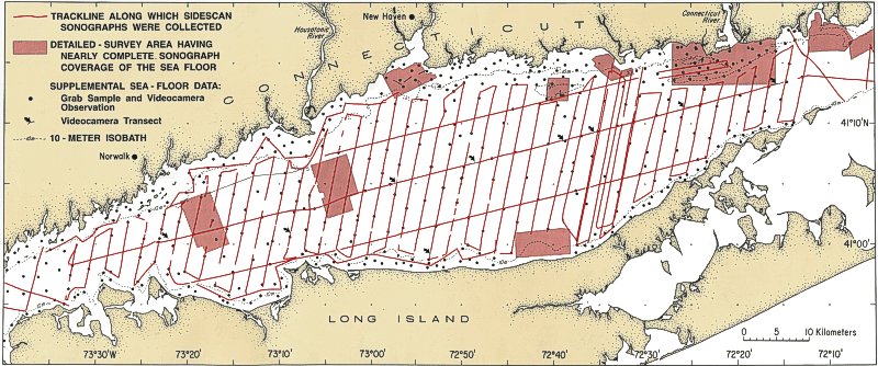 operated
at 100 kHz and scanned 187 m to each side of the ship's track. Sonographs
from the detailed survey areas (resulting in nearly complete sea-floor
coverage) were obtained using systems which operated at 100-120 kHz and
scanned 100-187 m to each side of the tracklines (Poppe and others, 1992,
1997, 1998a, b, 1999a, b; Mickle, 1997; Twichell and others, 1997, 1998).
Navigational control for all tracklines was provided by a differential
Global Positioning System (DGPS).
operated
at 100 kHz and scanned 187 m to each side of the ship's track. Sonographs
from the detailed survey areas (resulting in nearly complete sea-floor
coverage) were obtained using systems which operated at 100-120 kHz and
scanned 100-187 m to each side of the tracklines (Poppe and others, 1992,
1997, 1998a, b, 1999a, b; Mickle, 1997; Twichell and others, 1997, 1998).
Navigational control for all tracklines was provided by a differential
Global Positioning System (DGPS).
The sonographs were interpreted with the aid of a large amount of ancillary
marine-geologic data. These data included: (1) grab samples and videocamera
observations of the bottom at 413 stations (Fig.
2); (2) high-resolution seismic-reflection profiles (2 to 7 kHz
or 3.5 kHz) collected concurrently with all sonographs; (3) previous geologic
maps based on a regional set of subbottom (boomer) profiles (Lewis and
Needell, 1987; Needell and others, 1987; Lewis and Stone, 1991); (4) prior
regional maps of bottom-sediment types (Feldhausen and Ali, 1976; Reid
and others, 1979; Williams, 1981; Neff and others, 1988; National Ocean
Service, 1989a, b; Poppe and others, in press); (5) a regional suite of
vibracore samples (Donohue and Tucker, 1970; Williams, 1981; Lewis and
Needell, 1987; Needell and others, 1987; Szak, 1987); and (6) the detailed
bathymetry of the sea floor, having a contour interval of 1 to 2 m (U.S.
Geological Survey, 1984, 1986; National Ocean Service, 1989a, b).
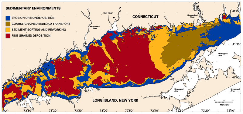 In
this section, we outline the general characteristics and locations of the
following four categories of bottom sedimentary environments present in
Long Island Sound: (1) erosion or nondeposition; (2) coarse-grained bedload
transport; (3) sediment sorting and reworking; and (4) fine-grained deposition
(Knebel and Poppe, in press) (Fig. 3).
It should be noted that these environments reflect the effects of dominant,
long-term processes. Atypical processes, which infrequently affect
the sea floor within each environment (such as storm erosion in fine-grained
depositional areas), could not be recognized in the sonographs because
they either did not leave a permanent imprint on the bottom or were below
the detection limit of the sensors.
In
this section, we outline the general characteristics and locations of the
following four categories of bottom sedimentary environments present in
Long Island Sound: (1) erosion or nondeposition; (2) coarse-grained bedload
transport; (3) sediment sorting and reworking; and (4) fine-grained deposition
(Knebel and Poppe, in press) (Fig. 3).
It should be noted that these environments reflect the effects of dominant,
long-term processes. Atypical processes, which infrequently affect
the sea floor within each environment (such as storm erosion in fine-grained
depositional areas), could not be recognized in the sonographs because
they either did not leave a permanent imprint on the bottom or were below
the detection limit of the sensors.
To open a georeferenced display of the sedimentary environments theme (Fig. 3) in ESRI's ArcView program make sure the application is loaded on your computer. Users should go to the lisound directory located on the top level of this CD-ROM and double click on the lisound.apr project file. The individual ArcView shapefiles may also be opened directly with any Arc application (e.g. ArcInfo, ArcExplorer) and can also be found on the data page. Further detailed information can be found on the ArcView Project File page.
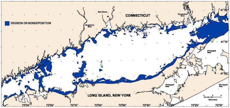 Environments
of erosion or nondeposition (Fig. 4)
contain exposures of glacial drift, coarse lag deposits and possibly bedrock
and include sediments which range from boulder fields to gravelly coarse-to-medium
sands. The bottom-sediment texture in these environments is typically
37-53% gravel-plus-coarse sand; 32-46% medium sand; 12-15% fine-plus-very
fine sand; and 2-3% silt-plus-clay. Ripples and small, low bedforms
are common on the bottom.
Environments
of erosion or nondeposition (Fig. 4)
contain exposures of glacial drift, coarse lag deposits and possibly bedrock
and include sediments which range from boulder fields to gravelly coarse-to-medium
sands. The bottom-sediment texture in these environments is typically
37-53% gravel-plus-coarse sand; 32-46% medium sand; 12-15% fine-plus-very
fine sand; and 2-3% silt-plus-clay. Ripples and small, low bedforms
are common on the bottom.
Environments of erosion or nondeposition cover 22% of the study area (Fig. 4). Within the deeper parts of the Sound, these environments were found mainly: (1) across the rugged topography at the eastern entrance to the Sound; (2) in patches atop north-south trending shoal complexes in the central and western Sound; and (3) over isolated topographic highs that protrude above the basin floor. Along the nearshore margins, they were found primarily in nearly continuous bands (water depths typically 10 m or less) which border most of the southern shoreline and much of the northern shoreline southwest of New Haven Harbor.
 Environments
of coarse-grained bedload transport (Fig.
5) are mantled by sand ribbons and sand waves and contain mostly
coarse-to-fine sands with only small amounts of mud. The sand ribbons
are typically 20-250 m wide and composed of sediments which average 33%
gravel-plus-coarse sand, 37% medium sand, 26% fine-plus-very fine sand,
and 4% silt-plus-clay. The sand waves have wavelengths which range
from 5 to 300 m, amplitudes which range from 0.25 to more than 10 m, and
textures which average 15% gravel-plus-coarse sand, 49% medium sand, 35%
fine-plus-very fine sand, and 1% silt-plus-clay.
Environments
of coarse-grained bedload transport (Fig.
5) are mantled by sand ribbons and sand waves and contain mostly
coarse-to-fine sands with only small amounts of mud. The sand ribbons
are typically 20-250 m wide and composed of sediments which average 33%
gravel-plus-coarse sand, 37% medium sand, 26% fine-plus-very fine sand,
and 4% silt-plus-clay. The sand waves have wavelengths which range
from 5 to 300 m, amplitudes which range from 0.25 to more than 10 m, and
textures which average 15% gravel-plus-coarse sand, 49% medium sand, 35%
fine-plus-very fine sand, and 1% silt-plus-clay.
Environments of coarse-grained bedload transport cover 13% of the study area (Fig. 5). They encompass an extensive area in the east-central Sound that has a hummocky tidal ridge-and-channel topography, which has developed on the surface of a postglacial marine delta. A few small patches of sand waves also are present atop and on the flanks of bathymetric highs in the central and western basin and along the nearshore margins.
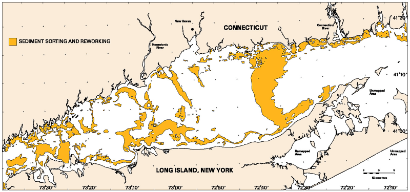 Environments
of sediment sorting and reworking (Fig. 6)
contain variable amounts of fine sand and mud and reflect a combination
of erosion and deposition. Sediments in areas of sediment sorting
are mostly uniform fine-to-very fine sands, with average textures of 8%
gravel-plus-coarse sand, 16% medium sand, 58% fine-plus-very fine sand,
and 18% silt-plus-clay. Sediments in areas of sediment reworking
contain heterogeneous textural patches which range in size from a few meters
to more than 200 m; their average texture is 7% gravel-plus-coarse sand,
7% medium sand, 25% fine-plus-very fine sand, and 61% silt-plus-clay.
Environments
of sediment sorting and reworking (Fig. 6)
contain variable amounts of fine sand and mud and reflect a combination
of erosion and deposition. Sediments in areas of sediment sorting
are mostly uniform fine-to-very fine sands, with average textures of 8%
gravel-plus-coarse sand, 16% medium sand, 58% fine-plus-very fine sand,
and 18% silt-plus-clay. Sediments in areas of sediment reworking
contain heterogeneous textural patches which range in size from a few meters
to more than 200 m; their average texture is 7% gravel-plus-coarse sand,
7% medium sand, 25% fine-plus-very fine sand, and 61% silt-plus-clay.
Environments of sediment sorting and reworking cover 24% of the study area (Fig. 6). Environments of sediment sorting are found primarily: (1) in a wide curvilinear band in the east-central Sound; (2) over the tops and on the flanks of bathymetric highs in the central and western basin; and (3) along an irregular strip which borders most of the southern margin (water depths of 10-20 m). Elsewhere, environments of sediment reworking are limited mostly to relatively small patches (encompassing only 3% of the total area) located in areas of low, irregular relief both within the basin and over the nearshore margins.
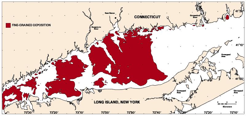 Environments
of fine-grained deposition (Fig. 7)
are blanketed by muds and sandy muds. As a group these sediments
have the finest grain sizes of the four sedimentary environments identified
in the study area. The average amounts of gravel-plus-coarse sand,
medium sand, fine-plus-very fine sand, and silt-plus-clay are 2, 2, 12,
and 84%, respectively.
Environments
of fine-grained deposition (Fig. 7)
are blanketed by muds and sandy muds. As a group these sediments
have the finest grain sizes of the four sedimentary environments identified
in the study area. The average amounts of gravel-plus-coarse sand,
medium sand, fine-plus-very fine sand, and silt-plus-clay are 2, 2, 12,
and 84%, respectively.
Environments of fine-grained deposition cover 41% of the study area
(Fig. 7). These environments
occupy large areas of the basin floor in the deeper-water parts of the
central and western Sound that have low topographic gradients. They
also are present in small patches over the nearshore margins, particularly
in coastal embayments and where sheltered by topographic highs and points
of land.
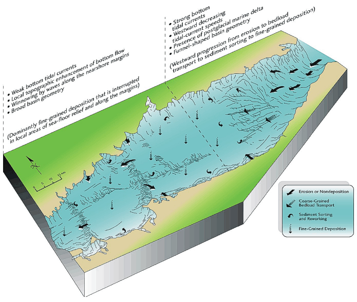 begins
with erosion or nondeposition at the narrow eastern entrance to the Sound,
changes to an extensive area of coarse-grained bedload transport in the
east-central Sound, passes into a contiguous band of sediment sorting (where
the estuary noticeably widens), and ends with broad areas of fine-grained
deposition on the flat basin floor in the central and western Sound.
However, the fine-grained deposits in the central and western parts of
the basin are locally discontinuous where the bottom flow is enhanced by,
and interacts with, the sea-floor topography (such as atop the shoal complexes).
Local patchiness also is prevalent along the nearshore margins. Here,
diverse assemblages of environments reflect the complex effects of wave-produced
bottom currents, the indented shoreline, irregular bottom relief, and a
proximal supply of sediments.
begins
with erosion or nondeposition at the narrow eastern entrance to the Sound,
changes to an extensive area of coarse-grained bedload transport in the
east-central Sound, passes into a contiguous band of sediment sorting (where
the estuary noticeably widens), and ends with broad areas of fine-grained
deposition on the flat basin floor in the central and western Sound.
However, the fine-grained deposits in the central and western parts of
the basin are locally discontinuous where the bottom flow is enhanced by,
and interacts with, the sea-floor topography (such as atop the shoal complexes).
Local patchiness also is prevalent along the nearshore margins. Here,
diverse assemblages of environments reflect the complex effects of wave-produced
bottom currents, the indented shoreline, irregular bottom relief, and a
proximal supply of sediments.
From the distribution of sedimentary environments we can draw two major inferences regarding the accumulation of fine-grained sediments. First, the regional east-to-west succession of sedimentary environments indicates that the Sound is highly efficient in trapping fine-grained sediments. Bottom sediments derived from coastal rivers and from the erosion and winnowing of the sea floor in the eastern Sound are transported westward (into the estuary) and are sequestered in the central and western parts of the basin. Second, using the accurately determined total area of deposition (1,226 km2) together with the estimated annual supply of sediments from all major sources (9.3 x 10⁸ kg/y), we calculate that the modern average accumulation rate of fine-grained sediments in the Sound is about 0.08 g/cm2/y (about 0.08 cm/y wet sediment) (Knebel and Poppe, in press). This regional accumulation rate is a standard or mean value against which local depositional rates can be compared and evaluated.
Data from this study can be used to address a broad range of environmental
topics for the Sound. The distributions of bottom sedimentary environments
and processes provide insight into the long-term fate of contaminants,
especially those associated with fine-grained sediments. This insight
can be used to predict where such contaminants will ultimately be transported
and deposited and to design monitoring programs which can document future
changes. Likewise, the data are a guide to the future utilization
of the sea floor. Future activities could include the emplacement
of structures on or within the bottom sediments, the disposal of dredged
spoil, or the assessment of sand and gravel resources. The data also
help to define the general locations and variability of benthic biological
habitats. This is because benthic habitats and sedimentary environments
are controlled by common factors such as sea-floor substrate and bottom-current
strength. Finally, the data give a long-term perspective of sea-floor
conditions in the Sound. As such, they provide a context within which
the effects of short-term (such as seasonal or annual) variations in bottom
processes can be evaluated.
Feldhausen, P.H., and Ali, S.A., 1976, Sedimentary environmental analysis of Long Island Sound, USA with multivariate statistics, in Merriam, D.F., ed., Quantitative Techniques for the Analysis of Sediments: An International Symposium: Oxford, Pergamon Press, p. 73-98.
Knebel, H.J., and Poppe, L.J., in press, Sea-floor environments within Long Island Sound: a regional overview: Journal of Coastal Research, in press.
Lewis, R.S., and Needell, S.W., 1987, Maps showing the stratigraphic framework and Quaternary geologic history of eastern Long Island Sound: U.S. Geological Survey Miscellaneous Field Studies Map MF-1939-A, 3 sheets.
Lewis, R.S., and Stone, J.R., 1991, Late Quaternary stratigraphy and depositional history of the Long Island Sound basin: Connecticut and New York, In: Gayes, P.T., Lewis, R.S., and Bokuniewicz, H.J., eds., Quaternary Geology of Long Island Sound and Adjacent Coastal Areas: Journal of Coastal Research, Special Issue No. 11, p. 1-23.
Mickle, S., 1997, Sidescan sonar and subbottom profiler investigations of the lower 25 km of the Connecticut River and adjacent Long Island Sound: Report to State of Connecticut, Department of Environmental Protection, Hartford, Connecticut, 34 p.
National Ocean Service, 1989a, Long Island east, bathymetric fishing map: National Ocean Service Sheet F75, scale, 1:100,000.
National Ocean Service, 1989b, New Haven, bathymetric fishing map: National Ocean Service Sheet F99, scale, 1:100,000.
Needell, S.W., Lewis, R.S., and Colman, S.M., 1987, Maps showing the Quaternary geology of east-central Long Island Sound: U.S. Geological Survey Miscellaneous Field Studies Map MF-1939-B, 3 sheets.
Neff, N.F., McMaster, R.L., Lewis, R.S., and Thomas, H.F., 1988, Non-energy resources: Connecticut and Rhode Island coastal waters: Report to U.S. Minerals Management Service, Washington, D.C., 47 p.
Poppe, L.J., Lewis, R.S., and Moffett, A.M., 1992, The texture of surficial sediments in northeastern Long Island Sound: U.S. Geological Survey Open-File Report 92-550, 13 p.
Poppe, L.J., Lewis, R.S., Zajac, R.N., Twichell, D.C., Schmuck, E.A., Parolski, K.F., and DiGiacomo-Cohen, M.L., 1997, Sidescan sonar image, surficial geologic interpretation, and bathymetry of the Long Island Sound sea floor off Hammonasset Beach State Park, Connecticut: U.S. Geological Survey Geologic Investigations Map I-2588, 2 sheets.
Poppe, L.J., Lewis, R.S., Denny, J.F., Parolski, K.F., DiGiacomo-Cohen, M.L., and Tolderlund, D.S., 1998a, Sidescan sonar image, surficial geologic interpretation, and bathymetry of the Long Island Sound sea floor in Niantic Bay and vicinity, Connecticut: U.S. Geological Survey Geologic Investigations Series Map I-2625, 2 sheets.
Poppe, L.J., Lewis, R.S., Knebel, H.J., Haase, E.A., Parolski, K.F., and DiGiacomo-Cohen, M.L., 1998b, Sidescan sonar images, surficial geologic interpretations, and bathymetry of New Haven Harbor, Connecticut, and the New Haven Dumping Ground, north-central Long Island Sound, In: Poppe, L.J., and Polloni, C., eds., Long Island Sound Environmental Studies: U.S. Geological Survey Open-File Report 98-502, Chapter 2, no. 8, 1 CD-ROM.
Poppe, L.J., Lewis, R.S., Denny, J.F., DiGiacomo-Cohen, M.L., and Parolski, K.F., 1999a, Sidescan sonar image, surficial geologic interpretation, and bathymetry of the Long Island Sound sea floor around Falkner Island, Connecticut: U.S. Geological Survey Geologic Investigations Series Map I-2671, 2 sheets.
Poppe, L.J., Lewis, R.S., Signell, R.P., Knebel, H.J., Persaud, M., Denny, J.F., Parolski, K.F., and DiGiacomo-Cohen, M.L., 1999b, Sidescan sonar image, surficial geologic interpretation, and bathymetry of the Long Island Sound sea floor off Roanoke Point, New York: U.S. Geological Survey Geologic Investigations Series Map I-2692, 1 sheet, 7 p.
Poppe, L.J., Knebel, H.J., Mlodzinska, Z.J., Hastings, M.E., and Seekins, B.A., in press, Distribution of surficial sediment in Long Island Sound and adjacent waters: texture and total organic carbon: Journal of Coastal Research, in press.
Reid, R.N., Frame, A.B., and Draxler, A.F., 1979, Environmental baselines in Long Island Sound, 1972-73: National Oceanic and Atmospheric Administration, Technical Report NMFS SSRF-738, 31 p.
Szak, C., 1987, The nature and timing of late Quaternary events in eastern Long Island Sound: Kingston, Rhode Island, University of Rhode Island, M.S. thesis, 83 p.
Twichell, D.C., Zajac, R.N., Poppe, L.J., Lewis, R.S., Cross, V.A., Nichols, D., and DiGiacomo-Cohen, M.L., 1997, Sidescan sonar image, surficial geologic interpretation, and bathymetry of the Long Island Sound sea floor off Norwalk, Connecticut: U.S. Geological Survey Geologic Investigations Map I-2589, 2 sheets.
Twichell, D.C., Zajac, R.N., Poppe, L.J., Lewis, R.S., Cross, V.A., Nichols, D.R., and DiGiacomo-Cohen, M.L., 1998, Sidescan sonar image, surficial geologic interpretation, and bathymetry of the Long Island Sound sea floor off Milford, Connecticut: U.S. Geological Survey Geologic Investigations Series Map I-2632, 2 sheets.
U.S. Geological Survey, 1984, Long Island west, New York-New Jersey-Connecticut, topographic-bathymetric map: U.S. Geological Survey Sheet 40073-E1-TB-100, scale, 1:100,000.
U.S. Geological Survey, 1986, Bridgeport, Connecticut-New York-New Jersey, topographic-bathymetric map: U.S. Geological Survey Sheet 41073-A1-TB-100, scale, 1:100,000.
Williams, S.J., 1981, Sand resources and geological character of Long
Island Sound: U.S. Army Corps of Engineers, Coastal Engineering Research
Center, Technical Paper 81-3, 65 p.
Figure 2. Locations of sidescan sonographs and supplemental data used to infer the modern sea-floor sedimentary environments within the Long Island Sound study area. The 10-m isobath delineates the nearshore margins along the Connecticut and Long Island coasts.
Figure 3. Map which shows the regional distribution of the four categories of sea-floor sedimentary environments identified within the Long Island Sound study area. This map is a digital version of the one presented in Knebel and Poppe (in press).
Figure 4. Distribution of environments of erosion or nondeposition, which cover 22% of the Long Island Sound study area.
Figure 5. Distribution of environments of coarse-grained bedload transport, which cover 13% of the Long Island Sound study area.
Figure 6. Distribution of environments of sediment sorting and reworking, which cover 24% of the Long Island Sound study area.
Figure 7. Distribution of environments of fine-grained deposition, which cover 41% of the Long Island Sound study area.
Figure 8. Perspective diagram which summarizes the major factors which have controlled the complex distribution of sedimentary environments in Long Island Sound. The dominant sedimentary environments within each part of the system are also indicated.