
Digital Mapping Techniques '00 -- Workshop Proceedings
U.S. Geological Survey Open-File Report 00-325
An Easy Non-GIS Method for Making 3-D Digital Terrain Illustrations Using USGS 1:24,000- and 1:250,000-Scale Digital Elevation Models and Bryce4 Software
By F. Craig Brunstein, Alex Donatich, Carol A. Quesenberry, Nancy A. Shock,
and Diane E. Lane
U.S. Geological Survey
Central Publications Group
Box 25046
Denver Federal Center, MS 902
Denver, CO 80225
Telephone: (303) 236-5477
Fax: (303) 236-6287
e-mail: cbrunste@usgs.gov
ABSTRACT
Three-dimensional (3-D) digital terrain illustrations offer the graphic designer and scientist an excellent way to portray certain geologic, geomorphic, tectonic, and topographic features for a range of scientific and popular publications. Making such illustrations has, until recent years, required the use of sophisticated GIS software, a steep learning curve, and much time and patience. A non-GIS software, Bryce4, used in conjunction with Adobe PhotoShop and Illustrator, provides graphic designers and scientists with an easy way to use USGS 1:24,000- and 1:250,000-scale Digital Elevation Models (DEM's) to make attractive 3-D terrain illustrations for use on the Web and in print and electronic publications. On this poster, we present the current status of non-GIS methods used in the USGS Central Publications Group to produce 3-D terrain illustrations for use in publications.
The poster presents a "cookbook" approach that includes all steps necessary to easily produce 3-D digital terrain illustrations. Toward that end, the poster reviews many of the steps discussed in Patterson (1998) and Sammis (1999). However, the poster presents additional information we think will be helpful to users, such as (1) how to maintain high resolution in 3-D terrain illustrations that will be used in print publications, (2) information on file formats and how to export 3-D images for further manipulation and corrections in Adobe PhotoShop and Illustrator, (3) information about tools in PhotoShop that are useful for manipulating colors and repairing imperfections in 3-D images exported from Bryce4, and (4) how to merge DEM's in Bryce4. The poster can be viewed and downloaded at URL http://cpg.cr.usgs.gov/.
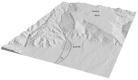
Poster: Grayscale 3-D image of the Raton, New Mexico-Colorado, 1:24,000-scale quadrangle. North is to upper right.
SOFTWARE FOR MAKING 3-D TERRAIN ILLUSTRATIONS
Bryce4: (a PC- and Mac-compatible computer program by MetaCreations); for more information see URL http://www.metacreations.com/.
MICRODEM/TerraBase II 4.0: (a PC-compatible computer program written by Peter Guth of the Oceanography Department, U.S. Naval Academy); can be downloaded free of charge at URL http://www.usna.edu/Users/oceano/pguth/website/microdem.htm. [Note: at the present time, this software has the ability to make, manipulate, and display 3-D terrain images, but no capability is provided in the software to export such images for use in other programs.]
MacDem Beta-0.7: [a Mac-compatible computer program written by Jerry Farm (macdemweb@treeswallow.com)]; can be downloaded free of charge at URL http://www.nacis.org/cp/cp28/resources.html. [Note: at the present time, this software has the ability to make, manipulate, and display 3-D terrain images, but we are unsure of its capability to export such images for use in other programs.]
USGS WEB SITE FOR DOWNLOADING 1:24,000- AND 1:250,000-SCALE USGS DEM'S
http://edc.cr.usgs.gov/doc/edchome/ndcdb/ndcdb.html
REFERENCES
Patterson, Tom, 1998, 3D landscape presentation-experiments at the U.S. National Park Service: Paper presented at the German Society of Cartography-Working Group of High Mountain Cartography, Bielerhöhe, Austria, February 26-March 1, 1998; also available on the World Wide Web at URL http://www.nps.gov/carto/silvretta/mtn.html (on the server of the North American Cartographic Information Society).
Sammis, Ian, 1999, How to make relief maps with Bryce: MacADDICT, v. 4, no. 12, p. 94-96.
U.S.Department of the Interior, U.S. Geological Survey
<https://pubs.usgs.gov/openfile/of00-325/brunstein.html>
Maintained by Dave Soller
Last updated 11.01.00