|
1National Park Service Natural Resources Information Division 1201 Oak Ridge Drive, Suite 350 Fort Collins, CO 80525 Telephone: (970) 225-3584 Fax: (970) 225-3585 e-mail: Steve_Fryer@nps.gov, Joe_Gregson@nps.gov, Anne_Poole@nps.gov |
2National Park Service Geologic Resources Division 12795 West Alameda Parkway P.O. Box 25287 Denver, CO 80225 Telephone: (303) 969-2093 Fax: (303) 987-6792 e-mail: Tim_Connors@nps.gov, Bruce_Heise@nps.gov |
The NPS Geologic Resources Inventory (GRI) is a cooperative endeavor to implement a systematic, comprehensive inventory of the geologic resources in NPS units. Cooperators include the NPS Geologic Resources Division, NPS Inventory and Monitoring (I&M ) Program (Natural Resource Information Division), U.S. Geological Survey (USGS), and individual state geological surveys (currently Colorado, Utah, and North Carolina). The GRI for the 265 park units with significant natural resources consists of four main phases:
GRI cooperators are developing geologic-GIS standards to ensure uniform data quantity and quality for digital geologic maps. In addition to standardized data definitions and structure, NPS resource managers also need user-friendly GIS applications that allow the digital geologic map products to "look and feel" like the original published paper maps. Pilot digitization projects are providing additional information for the evolving NPS digital map standards.
Park workshops suggest several applications for park resource management from an enhanced understanding of the parks' geology. Examples include the use of geologic data to construct fire histories, to identify habitat for rare and endangered plant species, to identify areas with cultural and paleontological resource potential, and to locate potential hazards for park roads, facilities, and visitors. Digital geologic maps will enhance the ability to develop precise hazard and resource models in conjunction with other digital data.
Upon completion of an inventory in a park, the available geological literature and data from the NPS, USGS, state, and academic institutions will be documented in a summary report. The content, format, and database structure of such reports are still being developed.
Digitization of geologic maps for Arches NP, Black Canyon of the Gunnison NP, Curecanti NRA, Craters of the Moon NM, Rocky Mountain NP, Bent's Old Fort NHS, Natural Bridges NM, and Florissant Fossil Beds NM has been completed.
Preliminary plans are to initiate digitizing projects in 2000 for all Utah parks with completed paper geologic maps (Bryce Canyon NP, Canyonlands NP, Capitol Reef NP, and Timpanogos Cave NM). The NPS Geologic Resources Inventory is being actively developed with the cooperation of USGS and state geological surveys. However, many opportunities for project collaboration may exist that have not yet been identified, and effective communication among cooperators is a key factor for success of the inventory.
Another challenge of inventory planning is the development of digital map standards that are adaptable to diverse geological conditions but still provide quality, uniform products and firm guidance for map developers. Indeed, the diversity of geologic resources found in the National Park System will provide a continuing challenge for effective project management. The National Park Service has identified GIS and digital cartographic products as fundamental resource management tools, and the I&M Program and Geological Resources Division are developing an efficient inventory program to expedite the acquisition of digital geologic information for NPS units throughout the country.
Since NPS resource managers use GIS as a tool in a wide array of collateral duties, the I&M Program is developing most digital products in ESRI (Environmental Systems Research Institute) ArcView GIS. ArcView interfaces effectively with other software running on the Microsoft Windows operating system. Also, using a variety of tools, including the Windows help software, a Microsoft Visual Basic graphics viewer program, the ArcView legend editor, and the Avenue script language, has allowed query and automatic display of published map information in the GIS.
This approach begins with the creation of the Help file table of contents (object table). The table includes a title, a listing all source map units (sorted by geologic age), and a list of source map references and notes. Text descriptions of map units, paginated by geologic age, are entered next. For compiled geologic maps, maps produced from more than one source map, a unit's description often consists of multiple map unit descriptions. At the end, the source map references and notes text, also one per page, were entered. Help context IDs (HELP_ID), topic names, keywords, page numbers, and linking codes were then added to the footnotes of each page. The data was then saved as a rich text format (.rtf) file, and compiled into a Windows help file.
Once compiled, the Windows help file can be opened and used with almost any Microsoft Windows software. The table of contents has each map unit symbol and unit name "hot-linked" to the descriptions, and each description is hot-linked to the references and notes. Using the built-in Windows help tools, users can jump instantly to the table of contents, page through the age-sorted unit descriptions, search for keywords, or index the file and perform full-text searches of the entire file. The Black Canyon/Curecanti pilot project help file consists of more than 50 printed pages of information for more than 130 map units. Advantages of the Windows help file are that most text formatting, such as font, size, color, etc., are preserved in the final product, many graphics and tables are also supported, and the help system can be developed somewhat independently of the digital geologic map.
In ArcView GIS, three Avenue scripts were written to function with a toolbar button to automate the Windows help file and call unit descriptions interactively from the geologic map. The button tool is only active when the geology theme is turned on. The user selects the map unit help tool from the ArcView toolbar and clicks on the desired map unit to view the associated unit description. Using the map unit symbol (GLG_SYM, see data model below) and the corresponding help context ID (HELP_ID), the Avenue routine loads the Windows help file and pages to the map unit description. Thus, the map unit descriptions and other text are interactively available to the user of the digital map.
To prepare the cross sections for viewing, the graphics are first scanned at 100 dots-per-inch (DPI) and saved as a digital JPEG (.jpg extension) graphics file. The JPEG format was chosen to allow the graphics to be served and viewed over the Internet in the future. Once again, the 8.3 file naming convention is used to facilitate sharing across all platforms, and file names are based on the map series designation and the designated cross section on the map (e.g., "gq1516a.jpg" is the A-A' cross section on the Geologic Quadrangle Map GQ-1516).
Although ArcView and the Avenue language provide several ways to display graphics and images, ArcView's capabilities are inadequate for efficient viewing of cross sections that could be up to 6" x 48" in size. Therefore, a simple VB graphics viewer program was developed to provide this capability. The viewer displays the graphics at 100% with the ability to scroll from one end of the section to the other.
In ArcView GIS, three Avenue scripts were written to function with a toolbar button to automate the cross sections and call graphics files interactively from the geologic map. The button tool is only active when the cross section theme (CODESEC, see data model section below) is turned on. The user selects the cross section viewer tool from the ArcView toolbar and clicks on the desired cross section line displayed on the map. Using the cross section line and the corresponding filename, the Avenue script loads the graphics viewer and displays the selected section. Thus, the cross sections are interactively available to the user of the digital map.
When a theme legend is completed, it can be saved as an ArcView legend file (.avl extension). In the data model, a legend file is named as per the theme/coverage file name. By default in ArcView, if a legend file exists with the same file name as a theme, when that theme is added to a view, the legend file is automatically loaded.
As with any digital map model, alterations and additional components, many derived from unique or uncommon map components, continue to advance and expand the model.
| CODEGLG | poly/line | Map units or main geologic spatial data containing both polygon data describing the map units and linear data describing the interface between those units. |
| CODEGLN | line | Map units or main geological spatial data |
| CODEGPT | point | Map units or main geological spatial data represented as points due to map scale limitations. |
| CODEFLT | line | Faults. |
| CODEFLD | line | Linear fold axes/hingelines. |
| CODEATD | point | Attitude observation points. |
| CODEDAT | point | Age-date sample location points (fossil or radiometric age estimates) . |
| CODEVNT | point | Volcanic vents, eruptive centers, features mapped as points. |
| CODEVLN | line | Linear volcanic crater, eruptive and flow features. |
| CODEDKE | line | Individual lithologic dikes. |
| CODEDKS | poly/line | Areas of lithologic dikes too numerous to map as individual segments (e.g. dike swarms). |
| CODEMIN | point | Mine and mining related features. |
| CODESEC | line | Cross section lines. |
| CODEASH | poly/line | Volcanic ash map units containing both polygon data describing the map units and linear data describing the interface between those units. |
| CODEMET | line | Metamorphic grade boundaries. |
| CODEMOR | line | Linear glacial moraine features. |
| CODEJLN | line | Linear joint features. |
| CODELN# | line | Contour and other lines. |
| CODESPF | point | Geologic point data deemed sensitive by NPS Unit. |
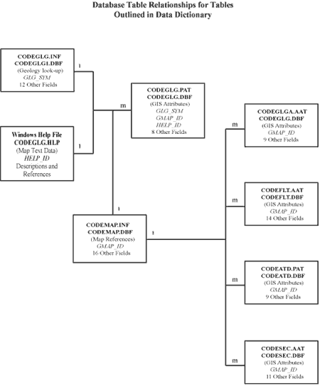
Figure 1.
Simplified relationships among database tables presented in data dictionary. Bold type denotes
database file names for ArcInfo (top) and ArcView (below). The tabular relationships are coded with
"m" for many, and "1" for one. Related field or key names are in italics. Table types are in parentheses.
___________________________________________________________________________________________________
SPATIAL THEME (FILENAME): Area Geologic Map Units (CODEGLG)
THEME DESCRIPTION: Polygon and Arc/line coverage(s)
TABLE COVERAGE/FILE NAME: CODEGLG.PAT (ArcInfo), CODEGLG.DBF (ArcView)
TABLE FORMAT: INFO table (ArcInfo), dBase IV (ArcView)
NUMBER OF FIELDS: 10
| FIELD NAME | TYPE-WIDTH | FIELD DEFINITION |
| AREA | F-4 | area of the polygon |
| PERIMETER | F-4 | perimeter of the polygon (in map units) |
| CODEGLG_ | B-4 | unique internal (PAL) sequence number for each polygon, ArcInfo CODEGLG#, converted in shape file .dbf |
| CODEGLG_ID | B-4 | sequence ID-number for each polygon, ArcInfo CODEGLG-ID, converted in shape file .dbf |
| GLG_IDX | I-6 | user-defined ID-number for each polygon |
| GLG_SYM | C-12 | age-lithology unit symbol, used to relate coverage with the CODEGLG1.INF look-up table |
| USGS_SYM | C-12 | geologic symbol from USGS geologic map(s) |
| GLG_AGE_NO | N-7.4 | number to age-sort units in legend |
| GMAP_ID | I-6 | unique number that relates map feature to series and citation information in CODEMAP.INF look-up table |
| HELP_ID | C-12 | code (code typically GLG_SYM value) used to link to associated geologic text in Help File System |
___________________________________________________________________________________________________
SPATIAL THEME (FILENAME): Geologic Map Unit Boundaries/Contacts (CODEGLG (ArcInfo)/CODEGLGA (ArcView)
TABLE COVERAGE/FILE NAME: CODEGLG.AAT (ArcInfo), CODEGLGA.DBF (ArcView)
TABLE FORMAT: INFO table (ArcInfo), dBase IV (ArcView)
NUMBER OF FIELDS: 11
| FIELD NAME | TYPE-WIDTH | FIELD DEFINITION |
| FNODE_ | B-4 | internal number of arc segment From Node, ArcInfo FNODE#, converted in shape file .dbf |
| TNODE_ | B-4 | internal number of arc segment To Node, ArcInfo TNODE#, converted in shape file .dbf |
| LPOLY_ | B-4 | internal left polygon number of arc segment, ArcInfo LPOLY#, converted in shape file .dbf |
| RPOLY_ | B-4 | internal right polygon number of arc segment, ArcInfo RPOLY#, converted in shape file .dbf |
| LENGTH | F-4 | length of arc segment |
| CODEGLG_ | B-4 | unique internal sequence, ArcInfo CODEGLG#, converted in shape file .dbf |
| CODEGLG_ID | B-4 | sequence ID-number for each polygon, ArcInfo CODEGLG-ID, converted in shape file .dbf |
| GLGCNT_IDX | I-6 | user-defined ID-number for each arc segment |
| GLGCNT_TYP | I-2 | code value for type of polygon (contact) boundary* |
| FLTCNT | C-1 | flags lithologic contacts that are also faults* |
| GMAP_ID | I-6 | unique number that relates map feature to series and citation information in CODEMAP.INF look-up table |
FLTCNT (contact a fault?)
___________________________________________________________________________________________________
SPATIAL THEME (FILENAME): Geologic Faults (CODEFLT)
THEME DESCRIPTION: Arc/line coverage
TABLE COVERAGE/FILE NAME: CODEFLT.AAT (ArcInfo), CODEFLT.DBF (ArcView)
TABLE FORMAT: INFO table (ArcInfo), dBase IV (ArcView)
NUMBER OF FIELDS: 15
| FIELD NAME | TYPE-WIDTH | FIELD DEFINITION |
| FNODE_ | B-4 | |
| TNODE_ | B-4 | |
| LPOLY_ | B-4 | |
| RPOLY_ | B-4 | |
| LENGTH | F-4 | length of arc segment |
| CODEGLG_ | B-4 | unique internal sequence, ArcInfo CODEFLT#, converted in shape file .dbf |
| CODEGLG_ID | B-4 | sequence ID-number for each polygon, ArcInfo CODEFLT-ID, converted in shape file .dbf |
| FLT_IDX | I-6 | user-defined ID-number for each arc |
| FLT_SEG_N | I-3 | number for each fault segment |
| FLT_SEG_T | I-2 | code value used to differentiate fault segment line types* |
| FLT_TYPE | I-2 | code value for type of fault offset/displacement* |
| FLT_LT | I-3 | fault and line segment type code value used for line representation* |
| FLTCNT | C-1 | flags faults that are also contacts* |
| FLT_NM | C-60 | fault name, if any, common to all arc segments with the same FLT_IDX. |
| GMAP_ID | I-6 | unique number that relates map feature to series and citation information in CODEMAP.INF look-up table |
FLT_TYPE (fault offset/displacement type code)
FLTCNT (fault also a contact?)
Special Note: A fault arc segment (FLTCNT = 'Y') has the down-thrown block on the right side of the arc. Thus, the down-thrown fault-block should be the arc segment's RPOLY_.
_________________________________________________________________________________________________
SPATIAL THEME (FILENAME): Attitude Observation Points (CODEATD)
THEME DESCRIPTION: Point Coverage
TABLE COVERAGE/FILE NAME: CODEATD.PAT (ArcInfo), CODEATD.DBF (ArcView)
TABLE FORMAT: INFO table (ArcInfo), dBase IV (ArcView)
NUMBER OF FIELDS: 10
| FIELD NAME | TYPE-WIDTH | FIELD DEFINITION |
| AREA | F-4 | |
| PERIMETER | F-4 | |
| CODEATD_ | B-4 | internal number for each point, ArcInfo CODEATD#, converted in shape file .dbf. |
| CODEATD_ID | B-4 | sequence ID-number for each point, ArcInfo CODEATD-ID, converted in shape file .dbf. |
| ATD_IDX | I-6 | user-defined ID-number for each point |
| FIELD NAME | TYPE-WIDTH | FIELD DEFINITION |
| ATD_TYPE | I-2 | code value for type of attitude measurement* |
| ATD_ST | I-3 | azimuth of strike or trend, (0-359) degrees clockwise from the north with dip direction clockwise from strike direction (right-rule method). Non-applicable strike values assigned a value of 999. |
| ATD_DP | I-2 | dip or plunge degrees from horizontal |
| ATD_AV_ROT | I-3 | ArcView symbol rotation value field, used for symbol presentation |
| GMAP_ID | I-6 | unique number that relates map feature to series and citation information in CODEMAP.INF look-up table |
___________________________________________________________________________________________________
SPATIAL THEME (FILENAME): Cross Section lines (CODESEC)
THEME DESCRIPTION: Arc/line coverage
TABLE COVERAGE/FILE NAME: CODESEC.AAT (ArcInfo), CODESEC.DBF (ArcView)
TABLE FORMAT: INFO table (ArcInfo), dBase IV (ArcView)
NUMBER OF FIELDS: 12
| FIELD NAME | TYPE-WIDTH | FIELD DEFINITION |
| FNODE_ | B-4 | |
| TNODE_ | B-4 | |
| LPOLY_ | B-4 | |
| RPOLY_ | B-4 | |
| LENGTH | F-4 | length of arc segment |
| CODESEC_ | B-4 | unique internal sequence, ArcInfo CODESEC#, converted in shape file .dbf |
| CODESEC_ID | B-4 | sequence ID-number for each polygon, ArcInfo CODESEC-ID, converted in shape file .dbf |
| SEC_IDX | I-6 | unique ID-number for each cross section line |
| SEC_ABV_O | C-6 | initial cross section abbreviation on geologic map |
| SEC_ABV | C-6 | cross section abbreviation on digital map |
| SEC_FILE | C-60 | file directory path and graphics file name of cross section .jpg file (ex. d:\gis-blca\graphics\I584a.jpg) |
| GMAP_ID | I-6 | unique number that relates map feature to series and citation information in CODEMAP.INF look-up table |
__________________________________________________________________________________________________
TABLE COVERAGE/FILE NAME: CODEGLG1.INF (ArcInfo), CODEGLG1.DBF (ArcView)
TABLE FORMAT: INFO table (ArcInfo), dBase IV (ArcView)
NUMBER OF FIELDS: 11
| FIELD NAME | TYPE-WIDTH | FIELD DEFINITION |
| GLG_SYM | C-12 | age-lithology unit symbol, used to relate the coverage with the CODEGLG1.INF or CODEGLG1.DBF |
| GLG_NAME | C-100 | formal name of map unit, if any |
| G_REL_AGE | C-5 | relative age of geologic units |
| G_SSCR_TXT | C-6 | subscript from the map symbol |
| GLG_AGE_NO | N -7.4 | number to age-sort map units in legend |
| G_AGE_TXT | C-50 | geologic time period of map unit |
| G_MJ_LITH | C-3 | code value for lithologic type* |
| G_LITH_ID | I-10 | code value used to describe lithology |
| G_LITH_TXT | C-100 | brief text describing lithology |
| G_NOTE_TXT | C-254 | descriptive notes about the map unit |
| GMAP_SRC | C-100 | source map(s) with organization and map series number (i.e. USGS GQ-1402, USGS GQ-1568) |
Example record from CODEGLG1.INF or CODEGLG1.DBF
_________________________________________________________
TABLE COVERAGE/FILE NAME: CODEMAP.INF (ArcInfo), CODEMAP.DBF (ArcView)
TABLE FORMAT: INFO table (ArcInfo), dBase IV (ArcView)
NUMBER OF FIELDS: 18
| FIELD NAME | TYPE-WIDTH | FIELD DEFINITION |
| GMAP_ID | I-6 | unique ID-number of map citation |
| GMAP_PARK | C-30 | list of NPS Unit alpha codes map is relevant to |
| GMAP_CODE | C-4 | unique 4-letter abbreviation code of map |
| GMAP_ABBRV | C-150 | abbreviation of map title, often includes map name and interpretation technique (e.g., Preliminary) and/or a map emphasize term on the distribution of specific materials (e.g., Surficial). |
| GMAP_YEAR | I-4 | compilation or publication year |
| GMAP_AUTH | C-254 | map author(s) |
| GMAP_ORG | C-100 | organization that created or compiled the map |
| GMAP_TITLE | C-200 | complete map title |
| GMAP_SER | C-40 | map series or organizational identifier (e.g., USGS GQ-1516) |
| GMAP_SCALE | I-7 | source map scale denominator |
| GMAP_PROJ | C-100 | name or description of map projection with projection datum |
| GMAP_REF | C-254 | complete map citation in USGS style |
| GMAP_DESC | C-254 | brief description of the map |
| GMAP_XMAX | F-8.6 | western limit of map in decimal degrees |
| GMAP_XMIN | F-8.6 | eastern limit of map in decimal degrees |
| GMAP_YMAX | F-8.6 | northern limit of map in decimal degrees |
| GMAP_YMIN | F-8.6 | southern limit of map in decimal degrees |
| GMAP_SRC | C-100 | source map(s) with organization and map series number (i.e. USGS GQ-1402, USGS GQ-1568) |
Example record for the Geologic map of Rocky Mountain National Park and Vicinity, Colorado. The 4-letter NPS alpha code for Rocky Mountain NP is ROMO.
ROMOMAP.INF or ROMOMAP.DBF
Gregson, Joe D., 1998, Geologic Resources Inventory--Geologic Resources Division, Inventory and Monitoring Program, in D.R. Soller, ed., Digital Mapping Techniques '98--Workshop Proceedings: U.S. Geological Survey Open-File Report 98-487, p. 109-111, https://pubs.usgs.gov/openfile/of98-487/gregson.html.
Harris, Carl F.T., 1998, Washington State's 1:100,000-Scale Geologic Map Database: An ArcInfo Data Model Example, in D.R. Soller, ed., Digital Mapping Techniques '98--Workshop Proceedings: U.S. Geological Survey Open-File Report 98-487, p. 27-35, https://pubs.usgs.gov/openfile/of98-487/harris.html.
Johnson, Bruce R., Boyan Brodaric, and Gary L. Raines, 1998, Draft Digital Geologic Map Data Model, Version 4.2: American Assoc. of State Geologists/U.S. Geological Survey Geologic Map Data Model Working Group, May 19, 1998, http://geology.usgs.gov/dm/model/Model42.pdf