Oklahoma Geological Survey
100 East Boyd Street, Room N-131
Norman, Oklahoma 73019-0628
Telephone: (405) 325-3031
Fax: (405) 325-7069
e-mail: twfurr@ou.edu
Since its beginning in 1993, the STATEMAP component of the National Cooperative Geologic Mapping Program has assisted the Oklahoma Geological Survey (OGS) in developing an ongoing geologic mapping program for the State of Oklahoma. To assist the OGS in establishing priorities of which areas of the State to map, the Oklahoma Geologic Mapping Advisory Committee (OGMAC) was formed. The OGMAC was established from representatives of State agencies, State planning associations, State industrial associations, and other organizations that have a Statewide perspective of geologic mapping needs in Oklahoma. Since its inception in 1993, the OGMAC has recommended two separate but related geologic mapping programs for the OGS to undertake.
The first program started in late 1994 when the OGMAC recommended that the OGS use digital technology to prepare a series of geologic maps at a scale of 1:100,000 for the entire State. The purpose of the maps is to provide a Geographical Information System geologic database of the State. In addition, the completed database would also provide the foundation for a new geologic map of Oklahoma, to be published at a scale of 1:500,000 (figure 1) (Suneson and Hemish, 1998).
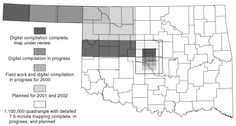
Figure 1. Status of the 1:100,000-scale digital geologic mapping program for the State of Oklahoma.
The second program is a continuation under STATEMAP of an older U.S. Geological Survey program called COGEOMAP, which was designed to provide detailed geologic maps and cross sections for areas that are of high-priority interest to federal and state agencies. At first, the OGS focused the STATEMAP mapping efforts in the Ouachita Mountains of eastern Oklahoma to complete the program that started in 1985 under the cooperative agreement between the OGS, the USGS, and the Arkansas Geological Commission (Johnson and Suneson, 1996).
In 1996, the STATEMAP program was shifted from the Ouachita Mountains when the OGMAC noted that no recent detailed geologic maps existed of the Oklahoma City Metro Area (OCMA). To remedy the problem, the OGMAC recommended a multi-year project of geologic mapping at a scale of 1:24,000. Their recommendation was based on the following factors:
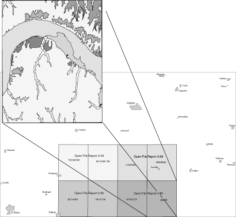
Figure 2. The Oklahoma City metro area surface-mapping program showing maps that have been released in the
Oklahoma Geological Survey's Open-File Report series.
Completed maps for the former COGEOMAP and current STATEMAP programs are available as paper maps in the OGS Open-File Report series. Also, consideration is being given to digitizing the maps for future addition to the 1:100,000-scale digital map series. The eight quadrangles that are presently available for the OCMA update reconnaissance geologic work that is almost 50 years old. The following maps are currently available for the OCMA:
| Piedmont-Bethany NE | OF 2-98 | $4.80 |
| Edmond-Arcadia | OF 3-98 | $4.80 |
| Bethany-Britton | OF 2-99 | $5.20 |
| Spencer-Jones | OF 3-99 | $5.20 |
The Oklahoma Geological Survey produces this information as a service to the public, engineering firms, and municipal and county agencies in the State.
Suneson, N.H. and Hemish, L.A., 1998, Review of the Geology and Stratigraphy of the Oklahoma City Metro Area--STATEMAP Progress Report: Oklahoma Geology Notes, v. 58, p. 4-20.