
Digital Mapping Techniques '00 -- Workshop Proceedings
U.S. Geological Survey Open-File Report 00-325
Development and Compilation of Comprehensive Geospatial Data, Coastal Alabama, for Integration into the Minerals Management Service's Gulf-Wide Information System (G-WIS)
By April Lafferty and Berry H. (Nick) Tew
Geological Survey of Alabama
P.O. Box 869999
Tuscaloosa, AL 35486-6999
Telephone: (205) 349-2852
Fax: (205) 349-2861
e-mail: alafferty@gsa.state.al.us, ntew@gsa.state.al.us
BACKGROUND
The Alabama Coastal area is a region of dynamic and complex coastal and near shore ecosystems and natural environments where anthropogenic factors and pressures have become increasingly significant. Parts of coastal Alabama have been extensively affected by rapid growth and development associated with urban and residential expansion, a flourishing tourism/resort industry along Gulf of Mexico beaches, and both onshore and offshore oil and gas exploration. Owing to the complexity and diversity of issues and problems related to the coastal area, its environmental sensitivity, and its importance to Alabama's economic and social development, the Geological Survey of Alabama (GSA) has conducted numerous scientific investigations in the area, many of which have led to published reports of findings. In addition, GSA is presently involved in various ongoing geological, hydrogeological, environmental, biological and energy-related studies directed toward collecting, compiling, assessing, and managing data from coastal and offshore Alabama. Geographic Information System (GIS) technology and the development and use of digital geospatial data have become increasingly important at GSA in recent years and are now routinely included as elements in nearly all research efforts at the agency. GSA has realized the benefits of GIS technology for data management and analysis and as a decision-support tool, and has made a strong commitment to an ongoing program of data development and management, as well as documentation of these data with Federal Geographic Data Committee (FGDC) compliant metadata records.
In 1995, the GSA participated in mapping shoreline types for use in oil spill contingency planning during the initial phases of the development of the U.S. Department of the Interior, Minerals Management Service (MMS), Gulf of Mexico Region, Gulf-wide Information System (G-WIS). The G-WIS was designed to provide a comprehensive database for oil spill contingency planning and environmental analysis in the Gulf of Mexico. One objective of the G-WIS was to have regional consistency of data across state boundaries and offshore (Louisiana State University, et. al., 1996).
Limited financial resources in 1995 restricted data development and GIS compilation to identification and attribution of shoreline types, biologic data, and other limited data sets. Other important data layers such as oil and gas infrastructure, roads, hydrography, and land use/land cover were still needed to complete the G-WIS. The GSA began gathering and developing the additional data layers in late 1999. This data development program targeted the Alabama coastal counties (Mobile and Baldwin) and the offshore Alabama state waters area. The successful completion of this project will result in a more comprehensive GIS database for the Alabama coastal area that will enhance the ability of MMS, state resource agencies, and others to make informed decisions regarding the development of Alabama's coastal and offshore resources in a safe, environmentally prudent manner.
PROJECT OBJECTIVES
The primary objectives of this project were as follows: (1) Identify the best available data/information resources for development or update of the data layers to be compiled; (2) Modify, compile, and integrate identified existing data into G-WIS specified digital format; (3) Develop new data sets, particularly up-to-date land use/land cover, as appropriate; and (4) Make all data developed as part of this project available to MMS, industry, and the public in various electronic formats and via various delivery mechanisms.
To address these objectives, the GSA undertook a coordinated effort to identify, acquire, update and convert existing data sets into the G-WIS standard format. The GSA coordinated closely with other state resource agencies, such as the State Oil and Gas Board of Alabama (OGB) and Alabama Department of Conservation and Natural Resources (ADCNR) to locate, enhance, or develop the needed data. The GSA identified several datasets such as land use/land cover, socioeconomic data and place names that did not exist and needed to be created.
DATA DEVELOPMENT AND
COMPILATION
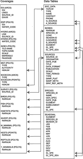
This data development program targeted the Alabama coastal counties (Mobile and Baldwin) and the offshore Alabama state waters area. All data sets were compiled in accordance with the G-WIS Database Specification Manual (Louisiana State University and others, 1996) and the Gulf-Wide Information System Data Dictionary. The G-WIS is comprised of ArcInfo coverages and associated lookup tables (Figure 1). These lookup tables included contact and source information for all socioeconomic and managed lands data and seasonality, breeding, and activity data for all biologic data layers. All data sets were documented with metadata developed according to the FGDC Content Standard for Digital Geospatial Metadata.
|
Figure 1. G-WIS Database Entity Relationship Diagram (modified from MMS, 1999).
|
Brief Overview of G-WIS Data Sets
Recent vintage (1995-1996) LandSat Thematic Mapper imagery (35m resolution) was classified to determine land use/land cover. This classification was based on a modified Anderson classification scheme developed at the U.S. Geological Survey (USGS). Fieldwork included mapping land use 'seed' sites onto enlarged paper copies of the imagery to serve as a check for the classification. Each 'seed' site was an area usually in excess of five acres that exhibited one of the land use types, such as planted pine forest, deciduous forested wetland, shrub/scrub, high density urban, etc. The imagery was then classified using ERDAS IMAGINE software. The classified image was spot checked against the seed sites to determine the accuracy of the classification. Rather than create an ArcInfo coverage (vector GIS layer) that would have caused unnecessary generalization of the data, the image was retained as a classified raster image that can be viewed and queried in various GIS packages. Previous attempts to convert raster to a vector images, such as a standard ArcInfo coverage, has yielded very generalized results that may not reflect accurately the original classification.
A coverage of all roads in the coastal counties (ROADS) based on the USGS Digital Line Graphs (DLGs) was created and attributed to match the G-WIS format of primary routes, secondary routes, and other roads. A point coverage of all place names on USGS topographic maps was created from the USGS Geographic Names Information System (GNIS). This data layer was created by querying the GNIS for all place names in Alabama, dumping the data to a text file, and then generating a point coverage in ArcInfo.
A state oil and gas lease block boundary coverage (LEAS_ST) was created from a Chart of Submerged State Lands produced by the ADCNR. The state/federal boundary was digitized to obtain an accurate representation of this boundary. A topographic map index coverage (INDEX) was created to include all USGS 7.5-minute topographic maps (scale 1:24,000) in Mobile and Baldwin Counties.
A managed lands coverage (MGT) of public lands managed by state and federal agencies was created from available shapefiles from the DCNR State Lands Division, the USGS, and the United States Forest Service. The shapefiles were obtained in a variety of projections and generated at a variety of scales. The GSA converted all shapefiles to ArcInfo coverages and projected them all to a common projection. Each newly generated coverage was reviewed and the coverages were appended into a managed lands coverage. Because many of the managed lands boundaries are unavailable, it is unlikely that this coverage includes all managed lands in the coastal counties, but it does include a significant portion of the available data.
Stream (STREAMS) and lakes (LAKES) coverages containing all linear and polygonal water-related features were created from USGS DLGs. All water bodies in the coverage that were labeled on the USGS 1:100,000 topographic maps were attributed with the name listed on the map. The human-use features point coverage (SOCECON) and associated attribute (SOC_DATA) and source (SOURCES) information was updated to include additional features (e.g., gas wells, gas platforms, factories, artificial reefs, etc.).
The biologic data table (BIORES) and species table (SPECIES) generated by another entity was updated to remove erroneous information. While reviewing the biologic data with ADCNR Marine Resources Division, two mammal species present off the coast of Alabama, the Bottlenose dolphin and the West Indian manatee, were identified as absent from the database. Although no systematic study of these marine mammals has been completed, some systematic and anecdotal information is available. A marine mammal (M_MAMMAL) polygon coverage to indicate marine mammal presence in the Alabama waters was created and associated seasonal, biores, species, and source tables were updated to include the marine mammal data. Data for these marine mammals were entered into the database in a generic fashion to include a presence in all Alabama coastal waters.
PLANS FOR THE ALABAMA G-WIS DATASETS
The G-WIS contains information that is applicable not only to oil spill contingency planning but also to coastal public access planning, urban and land use planning, and natural emergency contingency planning, among others. Therefore, the MMS has made all data available as shapefiles and DBF Tables via a CD-ROM. In late 2000, the GSA plans to provide, on their website (http://www.gsa.state.al.us/), many of the coverages generated during this project available via an interactive map. Additionally, the GSA will post much of the data on its clearinghouse, available (at the same URL) for download.
REFERENCES
Louisiana State University, Center for Coastal, Energy, and Environmental Resources; United States Minerals Management Service; Research Planning, Inc.; and Environmental Systems Research Institute, Inc., 1996, Gulf-wide Information System (G-WIS) Database Specifications Manual: Version 2.1, 72 p.
Minerals Management Service, 1999, Gulf-Wide Information System (G-WIS) CD-ROM: MMS 200-027.
U.S.Department of the Interior, U.S. Geological Survey
<https://pubs.usgs.gov/openfile/of00-325/lafferty.html>
Maintained by Dave Soller
Last updated 11.01.00