Kentucky Geological Survey
228 Mining and Mineral Resources Building
University of Kentucky
Lexington, KY 40506-0107
Telephone: (859) 257-5500
Fax: (859) 257-1147
e-mail: smartin@kgs.mm.uky.edu
A goal of this project is to construct a seamless geologic map for the Jackson Purchase Region; there are stratigraphic discrepancies between formations along some quadrangle boundaries, however. These discrepancies usually occur because of the original mapperąs differing opinions and interpretations, and because different topographic base maps were used. Stratigraphic problems encountered during edgematching of 7.5-minute geologic quadrangles include disparities between: (1) the Jackson Formation (Tj), the Claiborne Formation (Tc), and the Wilcox Formation (Tw); (2) the Clayton and McNairy Formation undifferentiated (TKcm) and the McNairy Formation (Km); and (3) Quaternary alluvial deposits (Qal) along alluvial stream valleys. The discrepancies between the Jackson, Claiborne, and Wilcox Formations were resolved by using compilation maps and data from the original mappers. The contact between the Clayton Formation and the McNairy Formation is difficult to map because of the lack of exposure and lithologic similarities. This discordance was solved by changing formation names along quadrangle boundaries where the disparities occurred according to original geologic map data and compilation maps of the area. Discrepancies also occurred between interpreted Qal boundaries in alluvial stream valleys because different base maps were being used, and because some alluvial valleys were mapped at different topographic elevations. Most of the discrepancies occur in smaller alluvial stream valleys that border map edges. Structural arc (i.e., structure contour lines) discrepancies also occurred along map boundaries, because each mapperąs interpretation of where to draw contour lines on erosional surfaces was different.
This digital geologic map of the Jackson Purchase Region was created using ArcInfo, and includes formations and structural arc coverages. The formation coverage consists of approximately 65,000 arcs and 25,000 polygons. Formation arcs represent stratigraphic contacts, faults, and map boundaries (state and county lines), whereas formation polygons represent geologic map units. The structural arc coverage represents contour lines drawn on the erosional surfaces that cut rocks of various ages. Data captured and attributed as coverages from the original 1:24,000-scale geologic quadrangle maps, but not included on this map, include structure point, economic, drill-hole, fossil, dike, and miscellaneous coverages. Miscellaneous coverages include data on slumps, sinkholes, and other geomorphic features. Included on this map are data derived from other sources that relate to the Jackson Purchase Region, and can be integrated with the digital geologic data. Aeromagnetic flight-line data provided by the Tennessee Valley Authority consist of point data that were gridded and then contoured using ArcInfo (figure 1). The paleogeologic map and the subsurface topographic map show elevation contours of Paleozoic bedrock, and was digitized using ArcInfo (figure 2).
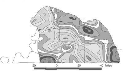
Figure 1. Magnetic anomaly map of the Jackson Purchase Region in western Kentucky. This map consists of point data provided by the Tennessee Valley Authority that has been gridded then contoured at 50 gamma intervals (Applied Geophysics, Inc., 1999). |
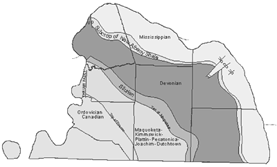
Figure 2. Subsurface topographic map and paleogeologic map of the Paleozoic bedrock surface in the Jackson Purchase Region (Schwalb, 1969). |
The discrepancies between interpreted boundaries for Quaternary alluvium (Qal) along stream valleys at map edges will be examined, and contacts altered with respect to topography on future versions of this map in order to provide continuity of mapped units between quadrangles. A stratigraphic column, lithologic descriptions, cross sections, and economic resource summary will also be included on future versions. Compiling the digital geologic quadrangle maps has provided insight to stratigraphic differences between quadrangles. This map could also be used to locate economic resources, and provide information about seismic risk, geologic hazards, and engineering construction projects in the Jackson Purchase Region.
Schwalb, H. R., 1969, Paleozoic geology of the Jackson Purchase region, Kentucky with reference to petroleum possibilities: Kentucky Geological Survey, series 10, Report of Investigations 10, 40 p.