
Preliminary map showing landslide densities, mean recurrence intervals, and exceedance probabilities as determined from historic records, Seattle, Washington
by J.A. Coe, J.A. Michael, R.A. Crovelli, and W.Z. Savage
Open-File Report 00-303, on-line edition
2000
![]()
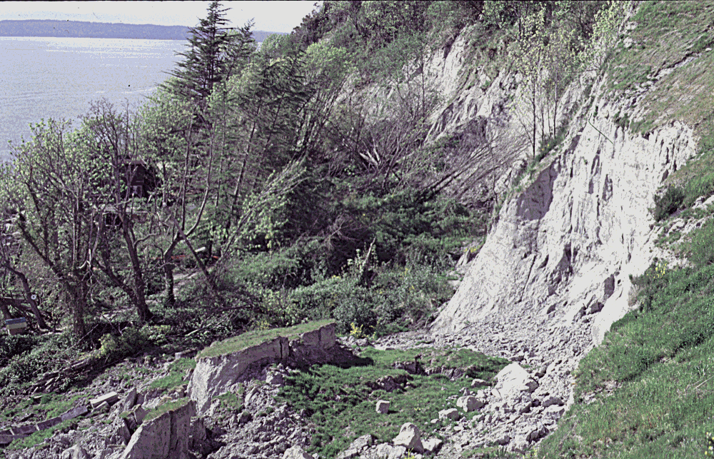
Bluff and recent landslide, western flank of Magnolia Hill, Seattle
This report is preliminary and has not been reviewed for conformity with U.S. Geological Survey editorial standards or with the North American Stratigraphic Code. Any use of trade, product, or firm names is for descriptive purposes only and does not imply endorsement by the U.S. Government.
U.S. Department of the Interior
U.S. Geological Survey
Preliminary map showing landslide densities, mean recurrence
intervals, and exceedance probabilities as determined from historic records,
Seattle, Washington
by J.A. Coe, J.A. Michael, R.A. Crovelli, and W.Z. Savage
INTRODUCTION
Landslides are a recurring problem on many hillslopes in Seattle, Washington (Tubbs, 1974; Galster and Laprade, 1991, Baum and others, 2000). Recently, in the 1996/97, 1997/98, and 1998/99 winter seasons, landslides caused widespread damage in Seattle. In the winter of 1996/97, when Seattle was especially hard hit by landslides (Gerstel and others, 1997; Baum and others, 1998a), damage to City facilities alone exceeded $34 million (Pageler, 1998).
In 1997, the U.S. Geological Survey Landslide Hazards Program, in association with the Urban Geologic and Hydrologic Hazards Initiative, began a project aimed at assessing landslide hazards within the City of Seattle. One of the goals of the USGS project was to provide a quantitative assessment of landslide occurrence and hazard within the City. A probabilistic assessment based on the historic record of landslides is one approach that can be used to provide an evaluation of landslide occurrence in the future.
Various types of probabilistic assessments are used by paleoseismologists, seismologists, and hydrologists in determining earthquake and flood hazards. In paleoseismology, the Quaternary record of earthquake events is routinely used to determine earthquake recurrence intervals and magnitudes, and subsequently provide probabilistic estimates of earthquake hazards from active faults (for example, Schwartz and Coppersmith, 1986; Nishenko and Buland, 1987; McCalpin, 1996; Working Group on California Earthquake Probabilities, 1999). Seismologists have produced probabilistic seismic hazard maps (since the mid-1970s) based on historic catalogs of earthquakes (for example, see Algermissen and Perkins, 1976; Frankel, 1995; Petersen and others, 1996). In flood hydrology, paleoflood and historical records are used to estimate flood frequency and probability of future occurrence (for example, U.S. Water Resources Council, 1982; Costa and Baker, 1981; Keaton and others, 1988).
The Poisson probability model is the most common model used in many probability studies in which pre-historic or historic events are modeled as occurring as random point events in time. The assumptions of the Poisson model (see Walpole and Meyers, 1985; Crovelli, 2000) are as follows: 1) the number of events which occur in one time interval or region of space are independent of the number that occurs in any other disjoint time interval or region, 2) the probability of an event occurring in a very short time interval or very small region is proportional to the length of the time interval or size of the region, 3) the probability that more than one event will occur in a short time interval or small region is negligible, and 4) the probability distribution of the number of events remains the same for all time intervals of a fixed length. In reality, most hazardous events, including landslides, are probably not independent and do not occur at random. For example, the occurrence of a landslide on a hillslope may make adjacent slopes more or less susceptible to future landslides, thus creating a zone of stability or instability in the future. Also, changing climatic conditions may consequently make the occurrence of landslides more or less likely in the future. Nevertheless, the Poisson model is often used when no information other than the mean rate of event occurrence is known. Under such circumstances, the Poisson model provides a good first-cut estimate for the probability of event occurrence in the future.
Although probability models such as the Poisson model have been available for quite some time, probabilistic assessments of landslide hazards that are based on historic records have been difficult to apply because most landslide records cover short periods of historical time, small geographic areas, and often do not contain time of occurrence information.
A landslide database recently compiled by Shannon and Wilson, Inc. for the City of Seattle (Nashem and Laprade, 1998; Laprade and others, 2000) provides an opportunity to apply a probabilistic approach to the evaluation of future landslide occurrence in Seattle. The database is unique in that it contains a record of landslide events covering the past 88 years. The database includes location and time of occurrence information, as well as many other landslide characteristics.
In this map report, we use the location of historic landslides from the July 1998 version of the database to 1) determine and map landslide densities and mean recurrence intervals, and 2) calculate exceedance probabilities for future landslide occurrence using a Poisson probability model as described by Crovelli (2000). The map, presented at 1:25,000 scale, provides a quantitative, spatial assessment of landslide occurrence in Seattle. A brief discussion of the map with respect to landslides on hillslopes where there are no historic records is included. The relation between exceedance probability and slope and geology is also discussed. This map report is considered preliminary because it is based on a preliminary version of the landslide database. An updated version of this map report will be published using the final version of the database, which was released while we were completing this report.
TERMINOLOGY
In this report the term "landslide" is used to describe all types of slope failures including slow-moving earth flows, rotational and translational slumps and slides (see Varnes, 1978, and Cruden and Varnes, 1996), and fast-moving debris flows composed of mud, gravels, and organic debris that often mobilize from landslides (see Pierson and Costa, 1987). Recurrence interval is used to describe the time interval between landslide events. Exceedance probability is defined as the probability (percent chance) of one or more landslides occurring during a specified time. Stated another way, exceedance probability is the probability of having at least one landslide during a specified time. We determined exceedance probability by first dividing Seattle into cells of equal area and then calculating exceedance probability at each cell for times in the future that ranged from 1 to 100 years. A complete description of the cells, as well as the equation used to calculate exceedance probability, is included in the methods section of this report.
GEOLOGIC SETTING OF SEATTLE
The Seattle area is covered by thick surficial deposits of primarily Pleistocene glacial origin (Waldron and others, 1961; Waldron and others, 1962). The most recent and extensive deposits in the area were a result of the Vashon stade of Fraser Glaciation, which ended about 13 ka. Deposits from the Vashon stade form N-S trending ridges throughout the Seattle area. These ridges, along with Puget Sound shoreline bluffs cut into Vashon and pre-Vashon deposits, have historically been the sites of numerous landslides. One of the primary sources of landslides has been the contact area between advance outwash deposits of sand and gravel of the Vashon stade and underlying transitional beds of fine-grained clayey silt deposited in lowland or proglacial lakes (Tubbs, 1974). Within the Seattle city limits, this area is known as the Esperance Sand/Lawton Clay contact. Landslides have also occurred within glacial and non-glacial deposits above and below this contact area, as well as within post-glacial colluvium.
DESCRIPTION AND LIMITATIONS OF THE LANDSLIDE DATABASE
The July 1998 version of the City of Seattle landslide database contains data starting in 1897 and ending in March 1998. Time of occurrence information (on a monthly basis) became available starting in November 1909. For this reason, and because only one landslide is recorded prior to November 1909, we consider November 1909 the starting date for the database and use 88.4 years as the database length in our mean recurrence interval and exceedance probability calculations (discussed in detail below).
The database consists of data from the archived files of three main sources, the Seattle Engineering Department (records from 1909 to present), the Seattle Department of Construction and Land Use (records from 1986 to present), and Shannon and Wilson, Inc. (records from 1954-present). Although the database is considered one of the most comprehensive records of landslides in the U.S. (Laprade and others, 2000), there are several spatial and temporal limitations of the data. First, very small landslides are not recorded in the database. In general, landslides in the database have slope heights (elevation differences between heads and toes) that are greater than 3 m. Second, whether or not a landslide is recorded in the database is largely controlled by the degree of reporting by the public, which is somewhat variable. Generally, landslides that did not affect right-of-ways, utilities, or private properties are not recorded, meaning that for the most part, the database is a record of landslides that caused damage.
Another limitation of the database is that it contains a mix of data recorded by several different government and private groups. The degree and accuracy of recording by these groups has varied over the 88 year time frame. Sporadic records were kept prior to about 1920. In the late 1930s and early 1940s, however, when the U.S. Work Projects Administration (WPA) kept excellent records of landslide occurrence as part of a comprehensive landslide stabilization study (see review of WPA work by Evans, 1994), landslides are well documented in the database. From the early 1940s to mid-1950s when there was no such organized effort, landslides are more poorly documented. From the mid-1950s to present, landslides are generally well documented in the database.
Specific limitations of the database that affect this study are those that revolve around uncertainties in recorded landslide locations. Landslide locations in the database are address based. The locations given in the database and shown on the map may be mislocated by up to about 50 m, for example, in a case where a landslide is across the street from the address where the person lived who reported it. The accuracy of recorded dates of landslide occurrence is variable (Laprade and others, 2000, and Chleborad, unpublished data, 1999) but does not adversely affect our results because we use the number of landslides within given areas in our analysis, not specific dates of occurrence (see discussion in methods section below).
INTENDED USE AND LIMITATIONS OF THE MAP
The map is intended to be used as a general guide to landslide occurrence, not as a predictor of hazard at specific sites. The map depicts the potential for landslide occurrence from hillslope source areas but does not depict slide paths or areas of landslide deposition. The map does not take the place of an on-site survey or professional judgment of a geologist of geotechnical engineer. Appropriate uses of the map include storm preparedness planning for emergency access and response.
One major limitation of the map is that it underestimates the true potential for landslides because the landslide database represents only a partial record of the actual number of landslides that have occurred since November, 1909. We use the term "underestimates" to mean that the calculated landslide densities and exceedance probabilities are too small and mean recurrence intervals are too large. This is especially true in unpopulated areas where non-damaging landslides have occurred, but is also undoubtedly true for populated areas where seemingly thorough records have been kept. A good example of the former situation is the sea bluffs along the southwest flank of Discovery Park (fig. 1). This area has no recorded landslides in the database but has experienced numerous recent landslides. The exclusion of such areas on the map does not mean that they are not susceptible to the occurrence of landslides, only that there were no recorded data that could be used to determine landslide occurrence.
Several characteristics of the database and map tend to overestimate the likelihood of future landslide occurrence. That is, these characteristics would tend to make the calculated landslide densities and exceedance probabilities too large and mean recurrence intervals too small. One of these characteristics is that, in some areas, landslide density contours extend into non-susceptible areas such as bluff tops far back from the edges of hillslopes and along beaches well below and away from the bases of hillslopes. Clearly, most of these relatively flat areas located far away from the edges of hillslopes are probably not susceptible to the occurrence of landslides. The problem is caused by the process of counting landslides and contouring landslide densities. The process, which is described in the methods section, uses a moving count circle approach to count landslides, and an automated contouring routine to create the landslide density contours. The location of the contours created using this approach is dependent on the number and location of landslides, but also, most heavily, on the size of the count circle. That is, any landslides that fall within the diameter of the circle are counted as if they were at the center of the circle. Even though we were careful to select a circle size that was optimal for the problem at hand, the approach still resulted in some flat areas being contoured. Eventually, contours in these areas could be eliminated, or at least be delimited, by combining results from this map report with a landslide susceptibility map (discussed briefly in the last section of this report).
Another limitation of the map, which would also result in future landslide potential being overestimated, is related to the fact that some susceptible areas that have had historical landslides have been significantly modified as a result of recent development. In some cases, retaining walls or other engineered structures have effectively removed these areas as possible sources of landslides. In these cases, the densities, recurrence intervals, and exceedance probabilities determined from historical data and shown on the map would probably overestimate the potential for landslide occurrence. In areas where hillslope modification is extreme, the hillslopes may no longer be sources for landslides. The hillslopes where development was most obvious were those near Jackson St. and Yesler Way near the downtown Central Business District (fig. 2).
One final limitation of the map was discovered on the basis of field checking the locations of landslides in the preliminary database. The field checking revealed that some single landslides were recorded multiple times in the database. This situation may have been caused by calls from multiple residents at multiple addresses surrounding a given landslide, or because the landslide was reported by two different sources, for example, residents and the Seattle Department of Construction and Land Use (DCLU). Multiple entries results in some areas having anomalously high density values and overestimated exceedance probabilities. Because this is a preliminary map, and because a systematic check of all of the landslides in the database was beyond the scope of this study, we have not attempted to remedy the multiple entry problem. We hope that in the final version of the database multiple entries will be eliminated and that the final version of this map can then be updated accordingly.
METHODS USED TO MAKE THE MAP
The map was made using ArcInfo, a commercially available geographic information system (GIS). The base materials and analyses used to make the map are described below. Unless indicated otherwise, all processing of base materials and analyses of data sets were done using ArcInfo.
Base materials
Slope, roads and railroads, and the Esperance/Lawton contact zone of Tubbs (1974) are used as a base (background) for the map. The slopes shown on the map were computed using elevations from USGS 10 m (100 m2 cell area) digital elevation models (DEMs). A slope value for each elevation cell was derived based on the maximum change in elevation from surrounding cells. Roads and railroads were extracted from the USGS 1:24,000 scale digital line graph (dlg) database.
Moving count circle approach used to determine landslide densities
Landslide densities shown on the map were determined based on the number of landslides occurring within a moving count circle (see Campbell, 1973). Count-circle software developed by the authors was used to determine landslide densities as follows. First, the City of Seattle was digitally overlain with a grid of 25 x 25 m (625 m2) cells. Next, a count circle covering an area of 40,000 m2 (4 hectares, equivalent in area to a 200 x 200 m cell) was digitally placed at the center of each cell and the number of landslides occurring within the circle were counted. The landslide density, or number of landslides within each 4 hectare count circle, was then assigned to the 625 m2 cell at the center of each circle. The grid of 625 m2 cells was then saved for later contouring and calculation of mean recurrence intervals and exceedance probabilities (see below).
The 625 m2 cell size was used because it is roughly equivalent in area to a average sized city lot. The 4 hectare count circle was used because it is roughly equivalent in area to the largest landslides that have occurred in the Seattle area (for example, the Woodway landslide covering about 5 hectares, Baum and others, 1998b; a landslide near the south end Perkins Lane covering about 3 hectares, fig. 1c; and a landslide on the west flank of Queen Anne Hill covering about 2 hectares, fig. 3). The combination of the 625 m2 grid cell and the 4 hectare count circle should allow for a reasonably realistic assessment of landslide occurrence at a scale that is useful to city and emergency preparedness planners.
Contouring the landslide density grid
The grid containing landslide density values was processed by ArcInfo to create the contours (also known as isopleths because they connect areas of equal densities, see Schmid and MacCannel, 1955) shown on the map. Two attempts at contouring were made before smooth, realistic contours were accomplished. The first attempt consisted of contouring the raw density grid. This resulted in unrealistic contours that were extremely blocky in appearance because they followed grid cell boundaries. The second attempt consisted of smoothing the density values prior to contouring. Each density cell value was slightly adjusted by applying a 3x3 neighborhood kernal to each cell. The kernal had 0.95 in the center cell and 0.007 for all other cells. The sum of the products of all cells replaced the original value for the center cell. Because the kernal was heavily weighted in favor of the center cell, the kernal only slightly altered the density values and the accuracy of subsequently created contours was not adversely affected. After the kernal was applied to the density grid, the grid was contoured using an interval of 4 landslides/4 hectares with the first contour at 2 landslides/4 hectares. The final step was to smooth the contours further using the ArcInfo Spline command.
Calculation of historic mean recurrence interval
Following methodology described by Crovelli (2000), the historic mean recurrence interval for each density value was calculated by dividing the time of the database record (88 years, 5 months, or 88.4 years) by the landslide count or the numerator in the density value. For example, a density of 2 landslides/4 hectares would have a mean recurrence interval of 44.2 years (88.4yr/2) whereas a density of 16 landslides/4 hectares would have a mean recurrence interval of 5.5 yr (88.4yr/16). This method of calculating mean recurrence interval is more accurate than calculating a mean using actual intervals. The reason for this is that when actual intervals are used, the period between the last event and the end of the database (which can range from days to tens of years) cannot be used in the calculation of the mean. This scenario could potentially result in very inaccurate mean recurrence intervals. For example, if there were two landslides at one count circle location, one occurring on November 2, 1911, and one occurring on November 2, 1913, the mean recurrence interval calculated from the actual intervals would be 2 years. The time between the last event and the end of the database, however, which could not be used as part of the calculation, would be more than 83 years.
Calculation of exceedance probability
Following methods described by Crovelli (2000), we consider the occurrence of landslides during a specified time in a particular area. In our case, the specified times range from 1 to 100 years and the area is each 625 m2 cell in the landslide density grid. We denote N(t) to be the number of landslides that occur during time t in each 625 m2 cell. The exceedance probability is defined as the probability of one or more landslides occurring during specified time t, that is, P{ N(t)³ 1} . The exceedance probability was calculated for each 625 m2 grid cell using a Poisson probability model described by Crovelli (2000) and derived as
P{N(t) > 1} = 1-e-t/m
where m is the future mean recurrence interval which is estimated by the historic mean recurrence interval calculated from the historical database (described above), and t is a period of time in the future for which the exceedance probability is calculated (for example, 1 year). The historic mean recurrence interval is used to estimate the future mean recurrence interval under the assumption that the future occurrence of landslides will be similar to the historic occurrence of landslides. Exceedance probabilities were calculated for 1, 5, 10, 25, 50, and 100 year periods. Exceedance probabilities for the 1 year period (annual exceedance probabilities) were stored as a separate grid for later comparative analyses with slope and geology (see discussion section).
DESCRIPTION OF RESULTS SHOWN ON THE MAP
Landslide densities, mean recurrence intervals, and exceedance probabilities are given in table 1 and shown on the map (plate 1). Densities range from 1 to 26 landslides/4 hectares. About 3.8 percent of the city has densities of 2 landslides/4 hectares or greater (table 2). Mean recurrence intervals range from 3.4 to 88 years. The lowest recurrence intervals correspond to the highest densities. Annual exceedance probabilities range from 1.1 to 25.5 percent. In any 100 year period, the chance of landslide occurrence in areas with landslide densities equal to or greater than 2 is 89 percent or greater. The highest densities, lowest mean recurrence intervals, and highest probabilities occur along Puget Sound in the Alki beach and West Magnolia areas. These areas have long been recognized as zones of landslide hazard (for example, see Tubbs, 1974, and Evans, 1994).
LANDSLIDES ON HILLSLOPES WITH NO HISTORIC RECORDS
Several hillslope areas that have no historical record of landslides are contiguous with hillslopes having moderate-to-high exceedance probabilities. Many of these hillslopes are located along Puget Sound on the western edge of the city. These hillslopes include, but are not limited to those in: West Seattle between Alki Point and Lowman Beach (fig. 4, plate 1), Magnolia Hill between the southern end of 32nd Ave. and the southern end of Perkins Lane, and Discovery Park north of Perkins Lane (fig. 1b). The probability of future landslide occurrence on these hillslopes cannot be assessed using historical data alone. The similarity between the slopes and geology underlying these areas to those underlying surrounding hillslope areas, however, suggests that they are susceptible to landslide occurrence. We visited several of these hillslopes and observed that they have no residential development. This raises the question of whether development causes landslides or whether landslides are actually occurring but are not being recorded because they do not cause damages. In at least one area, the Discovery Park area, landslides are quite abundant (fig. 1b), but simply not recorded. We strongly suspect that if these hillslopes were developed, the occurrence of landslides would be documented shortly thereafter.
DEVELOPMENT OF EQUATIONS TO ESTIMATE EXCEEDANCE
PROBABILITY ON HILLSLOPES WITH NO HISTORIC RECORDS
Landslides can be caused by many processes and characteristics including geological, morphological, physical (including rainfall and snowmelt), and human (Cruden and Varnes, 1996). Spatial variations in exceedance probabilities imply that the occurrence of landslides in Seattle is at least partly a function of varying physical characteristics of hillslopes. Two of the most important physical characteristics of hillslopes in Seattle are slope and geology (Galster and Laprade, 1991).
In the following two sections we explore the relation between exceedance probabilities and slope and geology. Our intention in these sections is to begin to develop a set of equations that can be used to estimate exceedance probability on the basis of measurable (or mapped) physical properties or characteristics. Although the sections provide equations that can be used to estimate approximate exceedance probability from slope and geology, other important characteristics are not addressed. These include variability in rainfall distribution, variability in vegetation, curvature/concavity of slope, and cultural influences that affect the surface-water contribution to hillslopes. The influence that these characteristics have on landslide occurrence is a subject for future research. If a complete set of equations can be developed, it should be possible to estimate exceedance probabilities for hillslopes where there is no historic record of landslides.
Relation between slopes and exceedance probabilities
The relation between slopes and exceedance probabilities is not easily defined. A scatter diagram of annual exceedance probabilities plotted as a function of slope for all grid cells where the exceedance probability is greater than 0 is shown in figure 5. Figure 5 shows that the majority of grid cells have annual exceedance probabilities less than 10 percent and slopes that range from 0 to 25°. Any positive or negative correlation between slopes and exceedance probabilities is difficult to see in figure 5. The use of mean slopes provides better insight into the relation between slopes and annual exceedance probabilities (fig. 6). Figure 6 indicates that there is a positive correlation between annual exceedance probabilities and mean slope. The steepest slopes, therefore, tend to have the highest exceedance probabilities. This correlation can be modeled using a power-law equation defined as y=0.0005x3.5153, where y is annual exceedance probability and x is mean slope. This equation provides a good fit to the data, with a coefficient of determination (r2) of 0.872. The equation most closely fits the data where the number of cells used to determine the mean slope is high (greater than 40, fig. 6). The model makes it possible to estimate an approximate annual exceedance probability for a given slope. Such an estimate, however, would probably be inaccurate without similar estimates for other important characteristics such as geology, rainfall, vegetation, curvature/concavity of slope, and cultural influences. For example, in the next section we consider geology and the influence that proximity to the Esperance/Lawton contact has on the occurrence of landslides.
Relation between the Esperance/Lawton contact and exceedance probabilities
The Esperance/Lawton contact zone is commonly regarded as the main source area for landslides in Seattle (Tubbs, 1974). In the winter/spring of 1972, a time of anomalously high landslide occurrence in Seattle (50 reported landslides), 40 percent of all landslides in the city occurred along the contact zone (Tubbs, 1974). Tubbs (1974) mapped the contact zone and described its influence in localizing the occurrence of landslides. His description, as compiled from various sections of his report, is quoted as follows. "Water can readily move down through the Esperance Sand until it reaches the top of the Lawton Clay. At that horizon its downward movement is halted, or greatly slowed, and the water moves laterally until it intersects a hillside. Therefore, along the trace of the contact there is often much seepage, which contributes to the saturation of debris resting upon the Lawton Clay. Where the Esperance Sand directly overlies pre-Lawton sediments, seepage and landslides are also common as a result of the same sort of ground-water conditions described above. It is possible to delineate a relatively narrow zone of particular landslide hazard near the base of the Esperance Sand. Landslides originating along the trace of the relevant contacts can affect areas both upslope and downslope from the line of origin. The hazardous zone is shown as having a finite width, but the hazard progressively decreases to either side of the trace and in some places extends beyond the boundaries shown. Because of the scale of geologic mapping in this area, the zone depicted on the map may locally be misplaced by several tens or even hundreds of feet."
As with slope, the relation between proximity to the Esperance/Lawton contact zone and exceedance probabilities is not easily defined. A scatter diagram of annual exceedance probabilities plotted as a function of distance to the contact for all grid cells where annual exceedance probability is greater than 0 is shown in figure 7. In a general sense, figure 7 shows that annual exceedance probabilities tend to increase as distance to the contact becomes smaller. However, the figure also shows peaks in annual exceedance probabilities at distances of about 50, 900, 1500, 3100, and 6900 m. All of these peaks (except the 50 m peak) are caused by areas that are not at all related to the contact (see plate 1). Examples of these include, Interlaken Park and Pigeon Point (900 m peak), Fuhrman Ave (1500 m peak), Laurelhurst (3100 m peak), and Rainier Ave (6900 m peak). According to the geologic map of Seattle (Waldron and others, 1962), Interlaken Park is underlain by Esperance Sand, Pigeon Point by Lawton Clay and Vashon Till, and Fuhrman Ave, Laurelhurst and Rainier Ave by Vashon Till. Clearly, it would not be appropriate to use an empirical relation between proximity to Esperance/Lawton contact and exceedance probabilities to estimate the likelihood for the future occurrence of landslides in these areas. Additional field investigations are needed in these areas to identify the main factor(s) that control susceptibility to landslides.
A better approach to evaluate the effect that the distance to the contact has on annual exceedance probabilities is to only analyze grid cells close to the contact. In order to define "close" we use guidance provided by Tubbs (1974) description of the contact zone. Specifically, that slides occur above and below the contact zone, and that the zone may be misplaced by up to several hundred feet. If we assume that "several hundred feet" means up to 300 ft, then landslides within about 100 m of either side of the contact could be initiated because of their proximity to the contact. Forty percent of all grid cells with annual exceedance probabilities greater than 0 occur within 100 m of the contact zone. For these areas, there is a positive correlation between annual exceedance probabilities and the percentage of all grid cells having each individual annual exceedance probability value (fig. 8). Stated another way, as annual exceedance probabilities become larger, the percentage of the total number of grid cells with each annual exceedance probability value also becomes larger. For example, 100 percent of cells with annual exceedance probabilities above 17 percent occur within 100 m of the contact zone, whereas only 28 percent of cells with annual exceedance probabilities of 1.1 percent fall within 100 m of the contact zone. The main conclusion to be made from data shown in figure 8 is that areas of the city where landslides are most likely to occur (all areas with annual exceedance probabilities above 17 percent) lie within 100 m of the contact.
The use of mean distance to the contact provides further insights into the relation between the contact and annual exceedance probabilities (fig. 9). Figure 9 indicates that there is a negative correlation between mean distance to the contact and exceedance probabilities. Areas close to the contact therefore, tend to have high exceedance probability values. The correlation is strongest where the number of grid cells used to derive the mean distance to the contact is larger than 1. All data points, including those where 1 grid cell was used to calculate the mean distance to the contact, can be modeled using a linear equation (fig. 9a). This equation provides a poor fit to the data, however, with an r2 value of 0.4451. A better fit is derived when the data points that were determined by 1 grid cell are not used. When these points are not used, the data can be modeled using a polynomial equation defined as y=-0.0108x2+0.104x+23.454, where y is annual exceedance probability and x is mean distance to the contact (fig. 9b). This equation provides a reasonably good fit to the data, with a r2 value of 0.7616. Figure 9b suggests that when the mean distance to the contact becomes very small (between 0 and 10 m) the annual exceedance probabilities remain constant at about 24 percent. The equation makes it possible to estimate an approximate exceedance probability for a given distance to the contact. Such an estimate, however, would have to be combined with similar estimates for other important factors (as mentioned above) in order to be useful.
POSSIBLE DIRECTIONS FOR FUTURE WORK
The use of a probability model that would take into account the probable non-random occurrence of landslides would be a productive direction to take in future work. The progression of probabilistic earthquake studies provides a possible path to follow for such an attempt. In earthquake studies, the Poisson probability model has been the most common model used to estimate earthquake probabilities (for example, see Schwartz and Coppersmith, 1986; Frankel, 1995; Petersen and others, 1996). Some recent work however, (see Working Group on California Earthquake Probabilities, 1999), uses a Brownian Passage Time (BPT) model to estimate earthquake probabilities in the San Francisco Bay Region. The BPT model uses two parameters, the mean recurrence interval between earthquakes, and the variability of recurrence intervals. The BPT model or a similar renewal process model could possibly be applied in future probabilistic assessments of landslides in Seattle.
Another extension of the work presented here would be to develop a method to estimate landslide probabilities for susceptible hillslopes in areas where historical records are not available. This would probably involve correlating physical characteristics of hillslopes to the calculated probabilities in well documented areas (as we did for slope and distance to the Esperance/Lawton contact) and then using these correlations, along with measured or mapped physical characteristics, to estimate the probability of landslide occurrence on hillslopes in undocumented areas. A different approach to solving the same problem would be to reconstruct historical landslide activity for all areas of Seattle by detailed landslide inventory mapping from historical sets of aerial photographs. The feasibility of this second approach, however, would be heavily dependent on the availability and scale of photographs.
Results from this mapping effort should be integrated with landslide susceptibility models and maps currently being developed for Seattle by the USGS. If susceptibility values can be correlated with exceedance probabilities determined from historic data in well-documented areas, then exceedance probabilities for landslides on hillslopes throughout the city could be estimated directly from susceptibility values. An outgrowth of this integration would the elimination of landslide density contours in non-susceptible areas such as bluff tops far back from the edges of hillslopes.
ACKNOWLEDGEMENTS
We thank John Ege, Mark Petersen, and Rex Baum for their critical reviews of this work. We also thank Phil Powers for his efforts in making this report available on the web.
REFERENCES CITED
Algermissen, S.T. and Perkins, D.M., 1976, A probabilisitc estimate of maximum acceleration in rock in the contiguous United States, U.S. Geological Survey Open File Report 76-416.
Baum, R.L., Chleborad, A.F., Schuster, R.L., 1998a, Landslides triggered by the Winter 1996-97 storms in the Puget Lowland, Washington: U.S. Geological Survey Open File Report 98-239, 16 p.
Baum, R.L., Harp, E.L., Likos, W.J., Powers, P.S., and Lahusen, R.G., 1998b, Real-time monitoring of bluff stability at Woodway, Washington, USA: in Evangelista, A. and Picarelli, L., eds., The Geotechnics of Hard Soils - Soft Rocks, Proceedings of the Second International Symposium on Hard Soils-Soft Rocks, Naples, Italy, Balkema, Rotterdam, pp. 1057-1065.
Baum, R.L., Harp, E.L., and Hultman, W., 2000, Recent landslides on coastal bluffs of Puget Sound between Shilshole Bay and Everett, Washington: U.S. Geological Survey Miscellaneous Field Investigations Map MF-xxx, in review.
Campbell, R.H., 1973, Isopleth map of landslide deposits, Point Dume Quadrangle, Los Angeles county, California, an experiment in generalizing and quantifying areal distribution of landslides: U.S. Geological Survey Miscellaneous Field Studies Map MF-535, scale 1:24,000.
Costa, J.E. and Baker, V.R., 1981, Surficial geology-building with the earth: Wiley & Sons, New York, 498 p.
Crovelli, R.A., 2000, Probability models for estimation of number and costs of landslides: U.S. Geological Survey Open File Report 00-249, 23 p.
Cruden, D.M. and Varnes, D.J., 1996, Landslide types and processes: in Turner, A.K. and Schuster, R.L., Landslides - Investigation and Mitigation, Transportation Research Board Special Report 247, p. 36-75.
Evans, S., 1994, Draining Seattle-WPA landslide stabilization projects, 1935-1941: Washington Geology, v. 22, no. 4, pp. 3-10.
Frankel, A., 1995, Mapping Seismic hazard in the central and eastern United States, Seismological Research Letters, v. 66, no. 4, p. 8-21.
Galster, R.W. and Laprade W.T., 1991, Geology of Seattle, Washington, United States of America: Bulletin of the Association of Engineering Geologists, v. 28, no. 3, pp. 235-302.
Gerstel, W.J., Brunengo, M.J., Lingley, W.S., Jr., Logan, R.L., Shipman, H., and Walsh, T.J., 1997, Puget Sound Bluffs: The where, why, and when of landslides following the holiday 1996/97 storms: Washington Geology, v. 25, no. 1, pp.17-31.
Keaton, J.R., Anderson, L.R., and Mathewson, C.C., 1988, Assessing debris flow hazards on alluvial fans in Davis County, Utah, in Fragaszy, R.J., ed., Twenty-fourth Annual Symposium on Engineering Geology and Soils Engineering: Pullman, Washington, Publications and Printing, Washington State University, p. 89-108.
Laprade, W.T., Kirkland, T.E., Nashem, W.D., and Robertson, C.A., 2000, Seattle Landslide Study, Shannon and Wilson, Inc. Internal Report W-7992-01, 164 p.
McCalpin, J.P., 1996, Paleoseismology, Academic Press, London, 588 p.
Nashem, W.D. and Laprade, W.T., 1998, Landslides in Seattle-historical documentation leads to failure mitigation: Association of Engineering Geologists 41st Annual Meeting, Program with Abstracts, p. 113.
Nishenko, S. and Buland, R., 1987, A generic recurrence interval distribution for earthquake forecasting, Bulletin Seismological Society of America, v. 77, p. 1382-1399.
Pageler, M, 1998, Landslide Policies for Seattle: A report to the Seattle City Council from the Landslide Policy Group, M. Pageler, chair, 35 p.
Petersen, M.D., Bryant, W.A., Cramer, C.H., Cao, T., Reichle, M.S., Frankel, A.D., Lienkaemper, J.J., McCrory, P.A., and Schwartz, D.P., 1996, Probabilistic seismic hazard assessment for the State of California: California Division of Mines and Geology Open-File Report 96-08, 59 p.
Pierson, T.C. and Costa, J.E., 1987, A rheologic classification of subaerial sediment-water flows, in Costa, J.E., and Wieczorek, G.F., eds., Debris flows/Avalances: Process, Recognition, and Mitigation, Geological Society of America, Reviews in Engineering Geology, V. 7, p. 1-12.
Schmid, R.H. and MacCannel, 1955, Basic problems, techniques, and theory of isopleth mapping: Journal of the American Statistical Association, v. 50, no. 269, p. 220-239.
Schwartz, D.P. and Coppersmith, K.D., 1986, Seismic hazards: new trends in analysis using geologic data: in Active Tectonics: National Academy Press, Washington, D.C., p. 215-230.
Tubbs, D. W., 1974, Landslides in Seattle: Washington Division of Geology and Earth Resources Information Circular 52, 15 p., 1 plate.
Waldron, H.H., Leisch, B.A., Mullineaux, D.R., 1961, Preliminary geologic map of Seattle and vicinity, Washington: U.S. Geological Survey Open File Report 61-168, scale 1:24,000.
Waldron, H.H., Leisch, B.A., Mullineaux, D.R., Crandall, D.R., 1962, Preliminary geologic map of Seattle and vicinity, Washington: U.S. Geological Survey Miscellaneous Geologic Investigation Map I-354, scale 1:31,680.
Walpole, R.E. and Meyers, R.H., 1985, Probability and statistics for engineers and scientists: Macmillan Publishing Company, New York, 3rd ed., 639 p.
U.S. Water Resources Council, 1982, Guidelines for determining flood flow frequency: Hydrology Commission, Bulletin 17b, 28 p., 14 appendices.
Varnes, D.J., 1978, Slope movement types and processes: in Schuster, R.L. and Krizek, R.J., eds., Landslides: Analysis and Control, Transportation Research Board Special Report 176, 11-33.
Working Group on California Earthquake Probabilities, 1999, Earthquake probabilities in the San Francisco Bay Region: 2000 to 2030 - a summary of findings: U.S. Geological Survey Open-File Report 99-517, 46 p.
| AccessibilityFOIAPrivacyPolicies and Notices | |
| |
|