| |
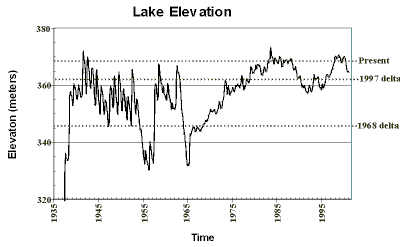
Surficial Geology and Distribution of Post-Impoundment Sediment in Las Vegas Bay, Lake MeadFigure 15. Graph showing monthly elevation of Lake Mead since 1935. The dotted lines show three lake elevations significant to this study. Present refers to the time of the survey (June, 2000), and the other two lines show the elevation of the lake during two periods of delta formation. Click on figure for larger image. | ||||||||||||
|
||||||||||||
| ||||||||||||
| ||||||||||||
|
||||||||||||