|
1Kansas Geological Survey The University of Kansas 1930 Constant Avenue Lawrence, KS 66049 Telephone: (785) 864-2139 Fax: (785) 864-5317 e-mail: david@kgs.ukans.edu |
2University of Applied Sciences Badstrasse 24 D- 77652 Offenburg, Germany |
In this project, real-time links are developed between an interactive geologic map of Montgomery County, Kansas, and related digital data and images stored in databases independent of the GIS. Most significant is the link established to the recently developed Kansas Geologic Names Database. Progress with the project was facilitated by the timely development of appropriate technologies, particularly improved software architectures.
The Kansas Geologic Names Database (LEXICON) has evolved, with extensive modification, from the text files used in publication of KGS Bulletin 231, Lexicon of Geologic Names of Kansas (through 1995), edited by Baars and Maples (1998). Development of the database was reported at the 1999 DMT Workshop in Madison, Wisconsin (Collins and Look, 1999). As indicated in that report, the database development process was a practical aid toward implementing the North American digital geologic map data model.
This report discusses the development of the Internet map service for Montgomery County and the associated interactive links to related data and images. The success of this effort supports other indications of the significant and increasing role that interactive Internet access to geologic maps and data will play in support of research, public policy analysis, and public information.
Ease of use is a high priority. Equally important, however, the project seeks to establish a framework to facilitate future development of additional, well-designed, interactive, digital geologic maps.
|
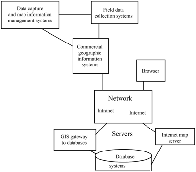
Figure 1. Generalized KGS interactive map environment. |
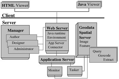
Data capture and map production activities at the KGS are accomplished with GIMMAP, an in-house mapping system (Geodata Information Management, Mapping, and Analysis Package). For more general applications, the KGS makes extensive use of GIS products from ESRI, including ArcInfo, ArcView, and ArcEditor. ESRI's Spatial Data Engine (ArcSDE) provides the gateway between the GIS packages and the Survey's database platform (ORACLE 8.1.7). The use of ESRI software is driven, in part, by the Survey's position as a research unit within the University of Kansas and the availability of ESRI site licensing through the University. At the heart of the interactive mapping environment is the Internet map server. As indicated previously, ESRI's ArcIMS was selected as the Internet map server for this project.
A diagram of the map service architecture is provided in Figure 2. ArcIMS (version 3) operates on the server side, providing map server management tools, geodata spatial servers, and the application server. Use of ArcIMS requires additional supporting components. A web server handles requests from clients and sends back a response. Requests are presented in HyperText Transfer Protocol (http). The KGS uses the Apache web server (version 1.3.14) running on a UNIX platform. Utilities in the Java Runtime Environment (JRE, version 1.2.1) provide the application program interface for running the Java2 components of ArcIMS.
| Figure 2. ArcIMS Architecture. |
|
The ArcIMS geodata spatial server provides two types of map services to the web server for response to the clients (users). With an image map service the client request is executed on the server and an image (GIF, JPEG, PNG) is generated and sent to the client machine. With a feature map service, vector features are streamed to the client machines. Many functions are then processed directly on the client machine. This project has utilized the image map service for its interactive mapping environment.
Additional map services query, geocode, and extract data from the databases for the geodata spatial server. These services do not affect the type of map service provided to the client (image or feature), but may or may not be required, depending on the type of client service. For more detailed information on this and other aspects of ArcIMS architecture and functionality, refer to ArcOnline, the ESRI resource center, at
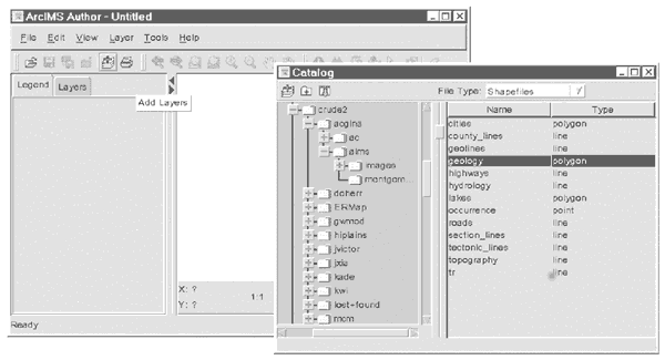
Figure 3. Defining layers from existing shape files, using the ArcIMS Author package. |
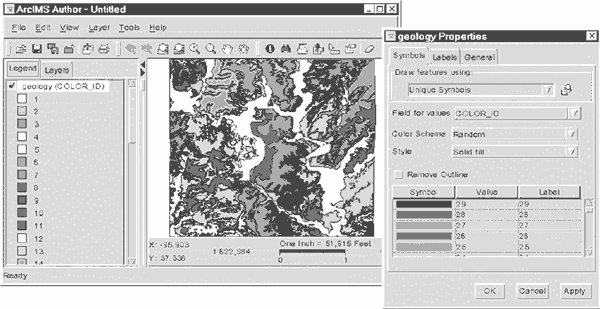
Figure 4. Definition of layer properties, using the ArcIMS Author package. |
|
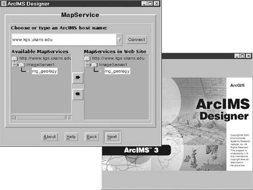
Figure 5. Specifying the ArcIMS host name with Designer. |
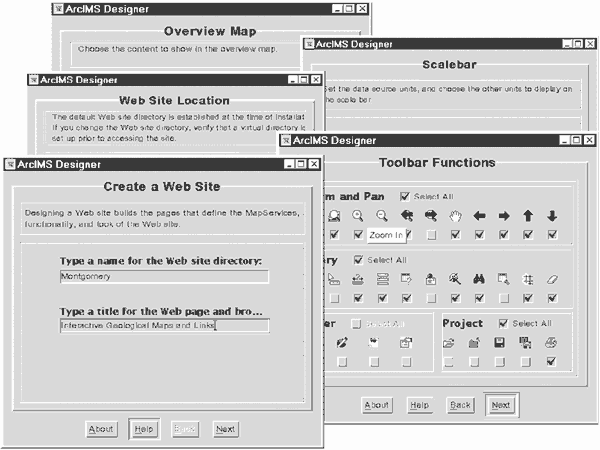
Figure 6. Utilities for creating and designing a map website. |
|
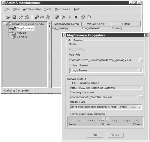
Figure 7. Setting map service properties with ArcIMS Administrator. |
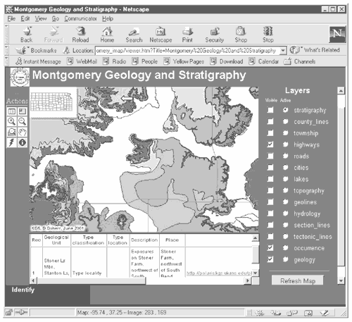
| Figure 8. Web site for the interactive geologic map of Montgomery County. |
|
As indicated in Figure 9, several select functions have been developed in the trial version. The second option, selecting data for a given sequence ID and map unit, uses the same starting parameters and the same procedures and functions as those needed in a query from an interactive geologic map. Prior development of the LEXICON package permitted testing of these procedures and functions before they were used with the interactive map.
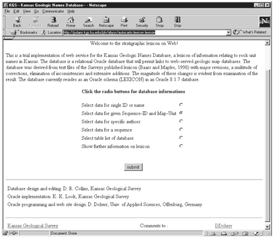
Figure 9. Home page for the online version of the Kansas Geologic Names Database. |
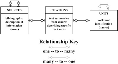
The heart of the Kansas Geologic Names Database is found in three primary tables, UNITS, SOURCES, and CITATIONS. Figure 10 presents the relationship between these tables and the general nature of their information content.
|
Figure 10. Primary tables in the Kansas Geologic Names Database, reflecting the interface of information source descriptions and defined rock units with specific citations. |
The structure of the data tables is important for all the select commands included in programs for online database presentation and for defining hyperlink access. For the initial development of Internet presentations, only some of the existing data tables and data fields in those tables have been used. The tables and fields most important for the current project are shown in Figure 11. "KID" is the acronym for the ten-digit, "Kansas IDentification" numbers used to uniquely identify records in ORACLE databases of the Kansas Geological Survey. The UNITS table is related to the CITATIONS table by the correspondence between the KID of the UNITS table and the UNIT_KID of the CITATIONS table. Similarly, the KID of the SOURCES table and the SOURCE_KID of the CITATIONS table relate the SOURCES table to the CITATIONS table.
| Figure 11. Tables, data fields and relations from the Kansas Geologic Names Database (LEXICON) that are significant for this project. Arrows show the relationship between different tables. "(FK)" = Foreign Key. |

|
The design of the original text files for KGS Bulletin 231 (Baars and Maples, 1998) imposed some undesired constraints on the initial development of the Kansas Geologic Names Database. One problem involves a lack of clear links between a particular abandoned nomenclature and associated citations when there have been changes in nomenclature for a rock unit.
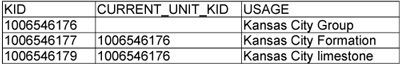
In many cases the revised nomenclature for a unit is basically the same as the abandoned form except for a change in rank or in the name of the parent unit. In other cases the name may not change at all, but the interval of rocks represented by that name may be redefined. In these situations, the old form of nomenclature is listed under the new form in Bulletin 231. These types of name changes sometimes resulted in several abandoned names appearing as a list under the most recent form. For example "Kansas City limestone" and "Kansas City Formation" are listed with the current nomenclature of the "Kansas City Group." Citations related to all of the identified forms of nomenclature are then grouped together in Bulletin 231, following the list of variations in nomenclature. The links between each citation and the corresponding appropriate variant must be interpreted from text. The limited information provided in many of the abstracts in Bulletin 231 is sometimes insufficient to establish the correspondence without reference to the original source document.
As a matter of expedience, the database was initially developed so that all citations following such groupings of nomenclature changes in Bulletin 231 are associated with the unique UNIT_KID for the nomenclature heading the list. Thus, in the UNITS table, records associated with the Kansas City variants would have the entries as shown in Table 1.
|
Table 1. UNITS [Click HERE for a Word version.]
|
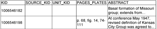
All references to the Kansas City Formation or Kansas City limestone would be found by all records in the CITATIONS table (see Table 2) where the value in the UNIT_KID field matches the KID of the UNITS table for the Kansas City Group.
|
Table 2. CITATIONS [Click HERE for a Word version.]
|
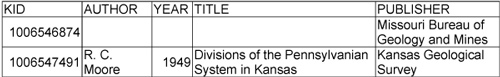
As indicated previously, the SOURCE_KID in the CITATIONS table provides the link to the KID in the SOURCES table for information on each citation's publication source (Table 3).
|
Table 3. SOURCES [Click HERE for a Word version.]
|
Eventually each citation in the database will be linked to the specific form of unit nomenclature used in that reference source.
Geologic maps and numerous published reports present information on stratigraphic sequences representing the regional geologic interpretations at the time of publication. These sequences are identified in the SEQUENCES table with a unique KID, NAME, and SOURCE_KID for the sequence. Figure 12 shows the selection of a specific stratigraphic unit (the Iola Limestone) from a scroll table of names from the stratigraphic sequence of units associated with the geologic map of Montgomery County, Kansas (Bennison, 1996). Figure 13 shows the web presentation of the resulting report.
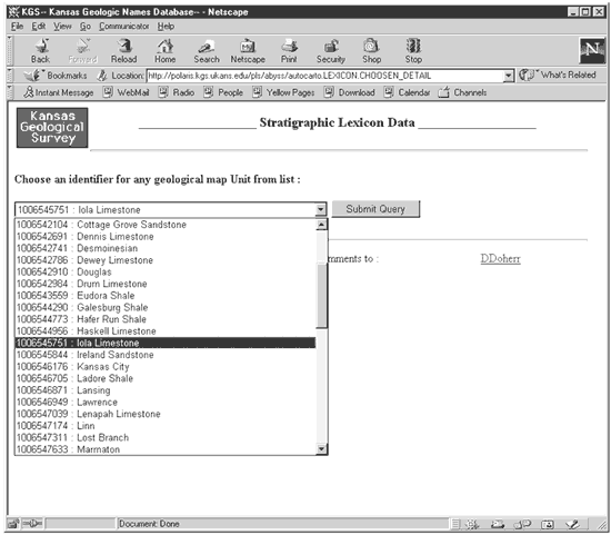
Figure 12. Selection of a specific stratigraphic unit from a scroll table presenting names from a sequence of units associated with a particular map or report. |
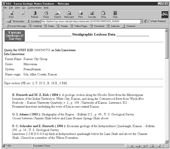
Figure 13. The resulting web page presentation of the report on the stratigraphic nomenclature history for the selected rock unit. |
Type localities - stratotype locations - of rock units are extracted from the OCCURRENCES table, which is related to the UNITS table by UNIT_KID. The current implementation does not make full use of the information contained in the OCCURRENCES table, but instead uses the simplest available query. This will be modified along with other extensions in the future.
The web output for the selected data is presented as a table, produced by several Oracle procedures that generate the header and footer for the web page and construct the data display, with appropriate formatting. See KGS Open-file Report 2001-33 (Doherr, Collins, and Ross, 2001) for details.
Stratigraphic intervals shown as polygons on a geologic map may represent one or more named rock units. From one map to another the grouping of units within mapped intervals may change. For example, the Tonganoxie Sandstone and Iatan Limestone members of the Stranger Formation are mapped as one interval on the Montgomery County map, but may be mapped separately in counties where the Iatan Limestone Member is more conspicuous. In other areas, a geologist might map the entire Stranger Formation as a single unit. Providing a useful link of digital geologic maps to the Kansas Geologic Names Database requires a database structure that permits correlation of mapped intervals on any map with the corresponding formally accepted nomenclature for the included rock units.
The SEQUENCES_DETAILS table (see Figure 11) is a correlation table defining many-to-many relationships between sequences, mapped units, and geologic unit names recognized for their past or present use in the professional geologic nomenclature. Within the SEQUENCES_DETAILS table, the SEQUENCE_KID for a map is associated with unique MAP_UNIT_KIDs for each of the geologic intervals represented on the map. Typically, the mapped interval is a recognized stratigraphic unit (member, formation, group, etc.). In that case there will be one record in the SEQUENCES_DETAILS table for that mapped interval on that map, with the map's SEQUENCE_KID and matching values for the MAP_UNIT_KID and UNIT_KID. Occasionally, the mapped interval is a grouping of geologic units recognized by the author as present in the area, but not shown in the detail of the map (e.g., the Tonganoxie Sandstone and Iatan Limestone members of the Stranger Formation). In this case there will be multiple records with the same SEQUENCE_KID and MAP_UNIT_KID, but with unique UNIT_KIDs for each of the units within the mapped interval. Where the grouping does not correspond to a recognized stratigraphic unit at a higher level, the MAP_UNIT_KID of the SEQUENCES_DETAILS table will appear as the KID for a record in the UNITS table. The unit will be identified as a "mapped interval" in the CURRENT_STATUS field of the UNITS table with an informal descriptive term or phrase used as the unit name in the NAME field.
To find the citations for a specific mapped interval, the select command must find those records (one or more) in the CITATIONS table containing the UNIT_KID identifiers from the SEQUENCES_DETAILS table associated with the MAP_UNIT_KID and SEQUENCE_KID parameters. Where multiple UNIT_KIDs are found with a single query, there will be a different data set selected from the CITATIONS table for each UNIT_KID.
As an example, Figure 14 shows the selection of a polygon representing the Lane Shale and Wyandotte Limestone formations of the Kansas City Group. With the "stratigraphy" layer active, and the "Identify" action selected from the tool buttons to the left of the map, the report shown in Figure 15 can be generated by clicking on the URL found in the "Stratigr.Lexicon" field of the attribute table displayed below the map (see Figure 14).
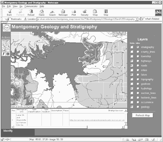
Figure 14. Selection of a polygon for a mapped interval with a non-standard aggregation of stratigraphic units. |
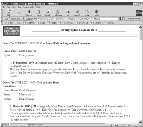
Figure 15. Report on nomenclature for the mapped interval consisting of the Lane Shale and remnants of the Wyandotte Limestone. |
The first part of the report presents a single citation from the Montgomery County map (Bennison, 1996) explaining the non-standard grouping of units within the mapped interval. This is followed by separate reports (in the same scroll window) on the nomenclature history of the two units included in the interval. With the "stratigraphy" layer active, the same nomenclature report could also be generated by selecting the "Hyperlink" action button (represented with a lightning bolt) and clicking directly on the polygon of interest.
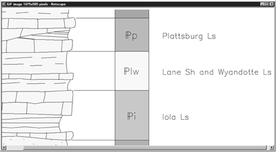
Graphic images related to the geologic map can also be retrieved from the ORACLE database using hyperlinks. Selecting "geology" as the active layer and selecting the "hyperlink" action tool button (Figure 16), an image of the portion of the stratigraphic column including an interval of interest can be displayed in a separate window by clicking on one of the polygons representing the desired interval. Figure 17 shows the result of clicking on a polygon representing the Lane Shale and Wyandotte Limestone (see Figure 16).
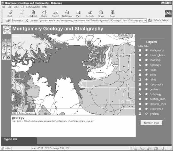
Figure 16. Use of the Hyperlink action tool with the "geology" layer active. |
|
Figure 17. Digital graphic image of a portion of the stratigraphic column for Montgomery County, Kansas, linked to the selected polygon on the interactive geologic map (Figure 16). |
Changes to databases linked to the interactive geologic map are available to the user in real-time. It is hoped that a well designed digital geologic map data model, served on the Internet with live links to these geologic databases, will encourage contributions of information and corrections to the database managers and facilitate appropriate data collection in the field. The trial Internet implementations of the interactive geologic map of Montgomery County, Kansas and of the Kansas Geologic Names Database may be accessed during their evaluation process at the following URLs:
Once the products are formally released by the Kansas Geological Survey, their location on the Survey's web site may change, but they will be accessible through the Survey's home page at http://www.kgs.ku.edu/.
Bennison, A.P., 1996, Geologic Map of Montgomery County, Kansas: Kansas Geological Survey, Map M-44, published scale 1:50,000, data compilation at 1:24,000.
Collins, D.R., and Look, K., 1999, Development of the Kansas Geologic Names Database: A Link to Implementing the Geologic Map Data Model Standards, in Soller, D.R., (ed.) Digital Mapping Techniques '99 - Workshop Proceedings: U.S. Geological Survey Open-file Report 99-386, p.107-111, https://pubs.usgs.gov/openfile/of99-386/collins.html.
Doherr, D., Collins, D.R., and Ross, J.A., 2001, Interactive Online Geologic Maps with Interactive Links to Multimedia Archival Data; a pilot project for Montgomery County, Kansas, February - July, 2001: Kansas Geological Survey, Open-file Report 2001-33.
Oracle Corporation, 1996, 1998, ORACLE Application Server-PL/SQL Web Toolkit: Oracle Corp., Part A60119-02, 43 p.
Ross, J.A., 1998, Providing Spatial Data and GIS Applications Via the Internet, in Soller, D.R., (ed.) Digital Mapping Techniques '98 - Workshop Proceedings: U.S. Geological Survey Open-file Report 98-487, p. 85-90, https://pubs.usgs.gov/openfile/of98-487/ross1.html and http://www.kgs.ukans.edu/General/Geology/dmt/spatial.html.