Coastal & Marine Geology Program
>
Subsidence and Fault Activation . . .
>
Open File Report 01-274
Return to:
Sediment Surface Profiles
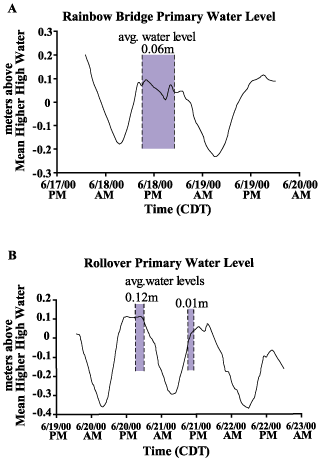
Fig. 8.
Water levels recorded at the (A) Rainbow Bridge and (B) Rollover Pass tide gauges during the field investigations. Locations of tide gauges shown on
Fig. 1
.
Return to:
Sediment Surface Profiles
Coastal & Marine Geology Program
>
Subsidence and Fault Activation . . .
>
Open File Report 01-274
[an error occurred while processing this directive]