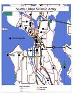
This is a description
of the configuration of the Seattle Urban Seismic Array at the time of the Nisqually earthquake and its aftershocks (from April 28 through March 3, 2001). The array is operated by
the Geologic Hazards Team of the U. S Geological Survey. It has been recording
small local earthquakes since its initial installation immediately after the Duvall earthquake in May of 1996. Since then,
we have been able to convert the array to all Kinemetrics K2s after retiring
the aging DR-200s in June of 1998. The array stations have been moved around
to suit our research interests. We had 26 instruments in urban Seattle at the
time of the Nisqually earthquake. The primary research goal of the array is
to record earthquake ground motion at sites scattered around the city that represent
the major types of surficial geologic materials found in the city. With this
information we plan to draw seismic hazard maps that will show the expected
variability of ground shaking throughout the city.
Version 1.1
|
| Posted October 2001 |
|
Part or all of this report is presented in Portable Document Format. The latest
version of Adobe Acrobat Reader or similar software is required
to view it. If you wish to download the latest version of Acrobat
Reader free of charge, click here.
|
|
