CAMP CADY RANCH
|
 |
|
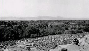
(1917). This view across the Mojave River floodplain, which was to become
the Camp Cady Ranch (upstream from historic Camp Cady), shows a band of
cottonwoods and Goodding willows along the Mojave River in the distance.
This unbroken band conceals the river channel and indicates that the riparian
system in the early 20th century was thriving (David Thompson 22, USGS
Photo Library).
|
 |
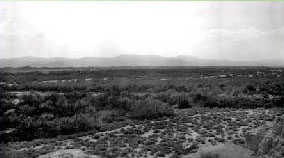
| (October 25, 2000). Much of the midground vegetation was cleared
for agriculture during private operation of Camp Cady Ranch. The ranch buildings
and surrounding lands are now owned by the California Fish and Game Department,
which ceased grazing and agriculture on the property shortly before this
photograph was taken. The stature of the riparian community has increased
as the cottonwoods have grown higher above the willows. Upstream and downstream
from this reach, riparian vegetation is dying owing to ground-water pumpage
(Dominic Oldershaw, Stake 2115c). |
| |
|
|
| (1917). Downstream of Barstow, the Mojave River crosses a
wide, sandy valley that, in 1917, had sand dunes and mesquite hummocks.
Where the river approaches the northwest side of the Cady Mountains, its
course apparently crosses a subsurface geological structure (either fault
or geologic strata) that forces ground-water towards the surface. A zone
of riparian vegetation consisting of mesquite, cottonwood, and Goodding
willow was well established here in 1917. The channel of the Mojave River,
which flows right to left across the center of this view, is relatively
wide (David Thompson 15, USGS Photo Library). |
|
|
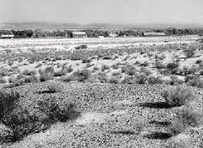
| (October 25, 2000). This view across the upstream part of
the Camp Cady Ranch shows a section where mortality of mesquite has been
high owing to upstream ground-water pumping, much of it immediately upstream
from the reach in this view, and tamarisk has increased considerably in
the midground. At the time of this photograph, tamarisk removal was occurring
in this reach. Despite the mortality, riparian vegetation increased during
the middle of the 20th century before the dieback because the channel of
the Mojave River is much narrower (Dominic Oldershaw, Stake 2117). |