[an error occurred while processing this directive]


OLD CAMP CADY

Photo--see description below.

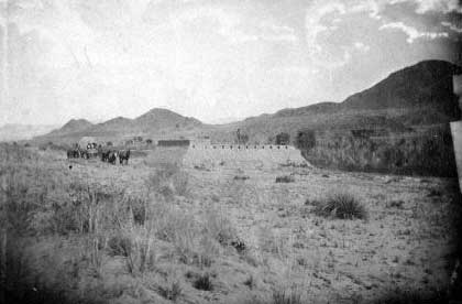
(1863). In the early 1860s, the U.S. Cavalry established several outposts at perennial water in the Mojave Desert for the protection of travellers along the Mojave Road, then known as the Government Road. The structure shown in this view is Camp Cady, on the north bank of the Mojave River northwest of the Cady Mountains. Behind and to the right of the fortification are riparian trees, which appear to be mesquite (plants just behind the fort), Goodding willows (both sides of fort), and coyote willow (right) (Richard D'Heureuse 1905-16894--A, courtesy of the Bancroft Library).

Photo--see description below.
(October 25, 2000). This view across the upstream part of the Camp Cady Ranch shows a section where mortality of mesquite has been high owing to upstream ground-water pumping, much of it immediately upstream from the reach in this view, and tamarisk has increased considerably in the midground. At the time of this photograph, tamarisk removal was occurring in this reach. Despite the mortality, riparian vegetation increased during the middle of the 20th century before the dieback because the channel of the Mojave River is much narrower (Dominic Oldershaw, Stake 2117).

First Previous Next Last

FirstGov button  Take Pride in America button