UPPER NARROWS (Victorville)
|
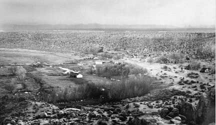 |
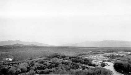
| (1917). Thompson photographed this upstream view of the Mojave River at
the Upper Narrows as part of a 360° panorama. The leafless trees indicate
the season is winter. The band of trees nearest the photograph appear to
be mostly Goodding willows, but scattered cottonwoods are also in the view
(David Thompson 445, USGS Photo Library). |
 |
|
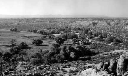
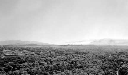
(October 24, 2000). Until recently, the ranch shown in the center of
this view remained in the same family that owned the property in 1917.
Most of the has been grazed continuously, but likely at varying intensities,
since 1917. Irrigation canals and water sources remain in approximately
the same places, indicating that ground-water levels likely have not fluctuated
significantly. Cottonwoods now dominate the trees in the view, and scattered
Goodding willows are still present (Dominic Oldershaw, Stake 2110a).
|
| |
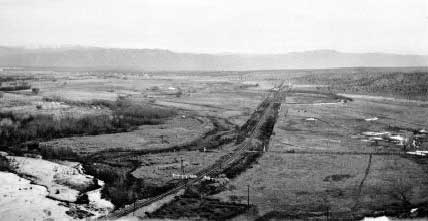 |
| (1917). This view, a pan to the left from the previous view, shows the
main railroad line from Los Angeles to Salt Lake City as it passes out of
the Mojave Desert into Cajon Pass and the Los Angeles basin. This single-track
line is built on a berm that forces most surface water moving down the Mojave
River to the left (east), although ground-water seepage appears in pools
on the right. At left, the river floodplain has scattered Goodding willows.
At right center, the railroad berm truncates a meander of the river, which
now appears to be a disconnected slough with scattered trees along its banks
(David Thompson 446, USGS Photo Library). |
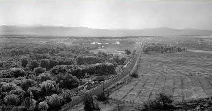 |
| (October 24, 2000). Most of the land to the left (east) of the railroad
is now in the Mojave Narrows Regional Park. Most of the trees visible are
cottonwoods, although Goodding willows are still present. The fields in
the right foreground are alfalfa, and cattle are grazing in the middle distance
in front of a line of cottonwoods growing along the slough (Dominic Oldershaw,
Stake 2110f). |
| |
 |
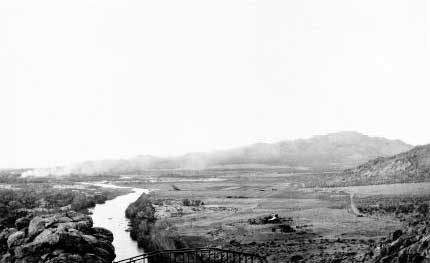
| (1917). In this third view, a pan even further to the left from the two
above, the trees appear to be mostly Goodding willow. A few cottonwoods
appear in this view, particularly one at lower center, and some low shrubs
along the channel appear to be coyote willows. The Mojave River is flowing
towards the camera and has a wide, mostly denuded floodplain. Vegetation
on this floodplain may be recovering from damages sustained in the 1916
flood, which was one of the largest on the Mojave River (David Thompson
447, USGS Photo Library). |
 |
|
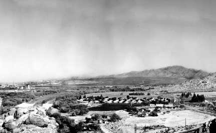
(October 24, 2000). Most of the riparian forest shown in this view is
in the Mojave Narrows Regional Park. The channel of the Mojave River has
decreased to a mere fraction of its former width, in part because of regulation
by dams upstream and the influence of the riparian vegetation. The trees
present are mostly cottonwoods, but very large Goodding willows and other
species are also present. The white haze in the background is smog over
Cajon Pass (Dominic Oldershaw, Stake 2110e).
|
| |
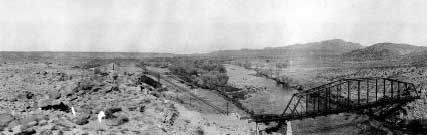 |
| (1901). This downstream view towards Lower Narrows shows the former highway
bridge across the Mojave River below the Narrows as well as the main railroad
line leading towards Barstow. The trees in the middle distance and on river
left are a mixture of cottonwoods and Goodding willows. The river channel
is very wide, probably in response to 19th century floods including the
1891 event (M.R. Campbell 173, USGS Photo Library). |
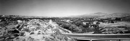 |
| (October 24, 2000). Cottonwoods and developments now dominate the view,
and the channel of the Mojave River cannot be seen. The old bridge was replaced
twice, once by a similar two-lane bridge and then more recently by the four-lane
bridge shown at lower right (Dominic Oldershaw, Stake 2111). |
| |
 |
| (1917). From a slightly different position than the 1901 view, above,
Thompson photographed this downstream view along the Mojave River. A few
ranches appear in the view, suggesting that grazing is a major land use
in the floodplain. The river apparently is in flood. A fire is sending smoke
from left to right across the background. Because of the architecture of
their branches, the small, leafless trees along the river appear to be Goodding
willows (David Thompson 450, USGS Photo Library). |
 |
| (October 24, 2000). Development associated with downtown Victorville has
changed the land use away from ranching, and no grazing occurs here. The
perennial flow creates ideal conditions for the growth of riparian vegetation.
The width of the channel has decreased by about two thirds, and the floodplain
now is occupied by tamarisk, native willows, and herbaceous species. Cottonwood
trees now dominate the river on both sides (Dominic Oldershaw, Stake 2110c). |
