ROBERT H. WEBB and DIANE E. BOYER, U.S. Geological Survey, 1675 W. Anklam Road, Tucson, AZ 85745;
U.S. GEOLOGICAL SURVEY OPEN-FILE REPORT OF 01-323, 2001
This report is also available in PDF format.
INTRODUCTION
Now, these photographs provide an invaluable record for evaluating changes in the riverine environment of the major water courses in Arizona. Riparian vegetation in particular is highly valued because of its biodiversity, wildlife habitat, and ability to favorably alter water quality. The long-term status of riparian ecosystems in the southwestern United States is much debated. Water development is frequently blamed for decimation or elimination of riparian ecosystems. Floods may damage or destroy vegetation within channels, and channel changes may cause damage to floodplain structures, agricultural fields, and water- and irrigation-supply systems. Increases in channel roughness may create higher stages during floods, raising the possibility of increased frequency of flood damage. The photography at gaging stations documents long-term changes in the riverine environments of Arizona. The images shown here are selected to illustrate the range of changes, which include large increases in native and non-native vegetation at most sites; complete elimination of riparian vegetation at some sites; and channel downcutting, lateral channel changes, and deposition of new fluvial terraces. The causes of many of the changes are not obvious. At some sites, riparian vegetation has increased despite the occurrence of large floods, flood control, or streamflow diversions. Despite the 20th century spread of tamarisk along the state's rivers, native species have increased as well. These photographs well illustrate the fact that Arizona's rivers have unstable channels and fast-changing riparian ecosystems, and management practices designed to protect Arizona's riparian ecosystems may benefit with this information. |
Download the PDF version of the report for high-resolution, printable pages (1MB).
Document Accessibility: Adobe Systems Incorporated has information about PDFs and the visually impaired. This information provides tools to help make PDF files accessible. These tools convert Adobe PDF documents into HTML or ASCII text, which then can be read by a number of common screen-reading programs that synthesize text as audible speech. In addition, an accessible version of Acrobat Reader 5.0 for Windows (English only), which contains support for screen readers, is available. These tools and the accessible reader may be obtained free from Adobe at Adobe Access.
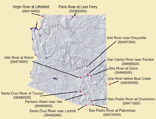 As
part of the regular operation of surface-water gaging stations in Arizona,
photographs are taken to document channel conditions. The photographs
show many features of the channel that are important to accurate streamflow
gaging, including shifts in channel thalwegs (the deepest point in the
channel), changes in low-water controls, and changes in channel roughness.
Photographs have been taken since gaging stations were first established
in Arizona in the 1910s, and many photographs were taken in the 1920s
and 1930s.
As
part of the regular operation of surface-water gaging stations in Arizona,
photographs are taken to document channel conditions. The photographs
show many features of the channel that are important to accurate streamflow
gaging, including shifts in channel thalwegs (the deepest point in the
channel), changes in low-water controls, and changes in channel roughness.
Photographs have been taken since gaging stations were first established
in Arizona in the 1910s, and many photographs were taken in the 1920s
and 1930s.