 |
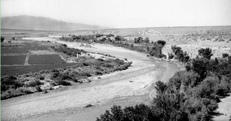
(June 4, 1942). This downstream view from a bluff above the Virgin
River shows the gaging station at Littlefield, Arizona, in the extreme
northwestern part of Arizona. The channel was relatively wide and
free of vegetation, with cottonwoods along river right (right side
of the photo) and mesquites and tamarisks along river left. Although
the river is used extensively for irrigation and domestic water supply,
no dams have been built across the main channels (James Baumgartner,
#3601). |
| |
|
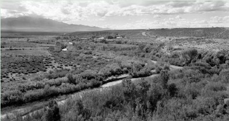
| (October 30, 2000). Despite several large floods in the intervening
58 years, including a January 1,1989, flood caused by the breaching
of an off-channel dam upstream, riparian vegetation has increased
in this reach. Most of the foreground vegetation is native, including
cottonwood trees, arrowweed, mesquite, and catclaw. At lower right,
a marsh containing reeds, cattails, and phragmites has developed.
On river left, native coyote willow lines the bank, and a prominent
zone of tamarisks with occasional cottonwood appears behind. The vertical
bank at center is in a small floodplain terrace that developed after
1942 (Dominic Oldershaw, Stake 1727). |
 |
| |
| Next: Paria River at Lees
Ferry (0-382000)
Previous: Introduction
|
|


