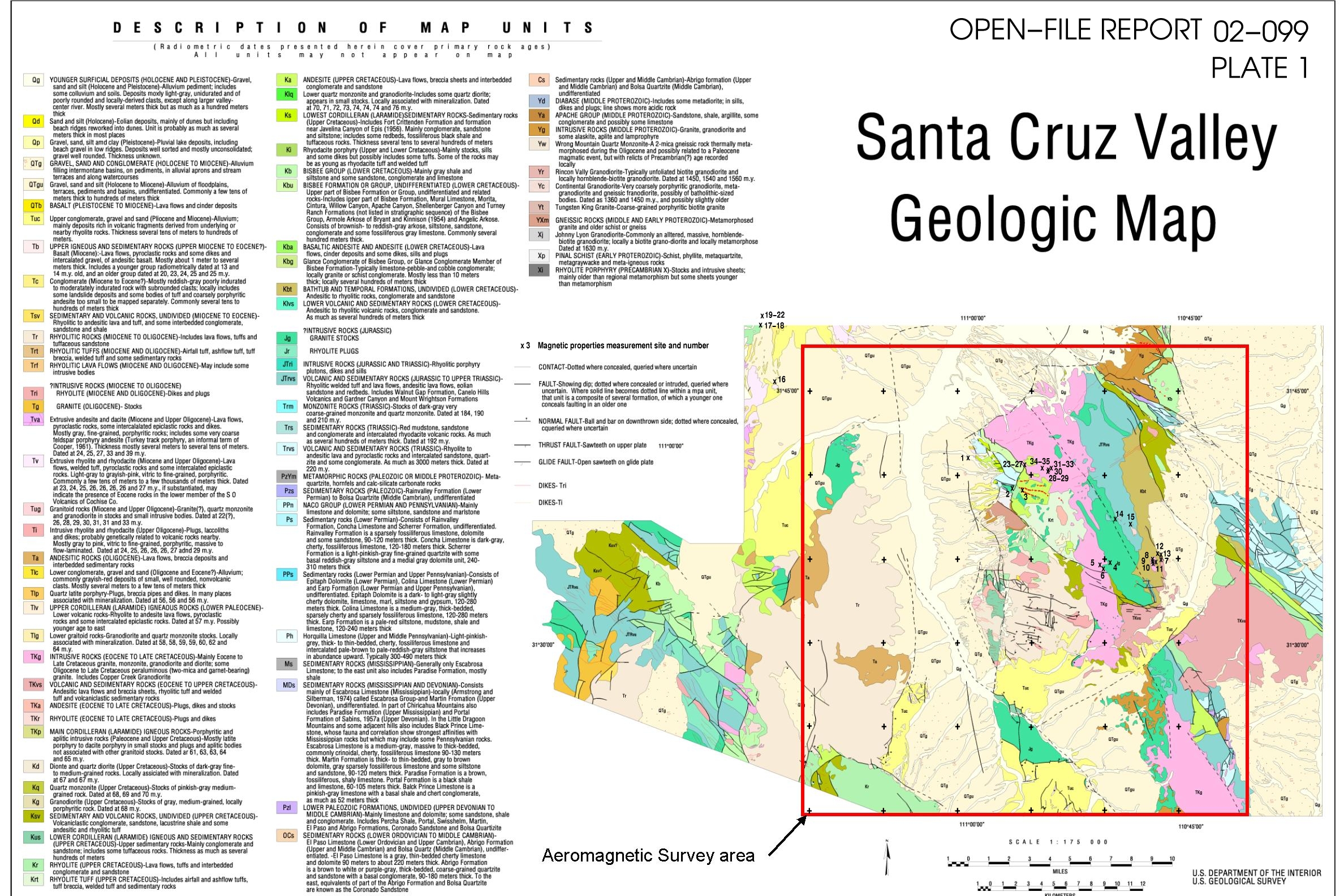
Open-File Report 02-99
Measurements of rock magnetic
susceptibility, remanent polarity, or both, were completed at 35 sites within
the study area, of which 20 are susceptibility only. The results of these measurements
are presented in tabular form in Table 1 and the distribution of sites is shown
on the plate 1. Magnetic susceptibility was measured
using a Sapphire Instruments model SI-1 equipped with a 20x20 cm flat field
coil designed for measurements on outcrops. Remanent magnetic polarities were
measured using several fluxgate magnetometers made by California Instruments
(model 70 magnetometer). The use of brand names in this document is for descriptive
purposes only and does not constitute endorsement. For the polarity measurements,
oriented hand samples of 0.5 to 5 kg mass were used. Care was taken in collection
of oriented samples to sample from areas which appeared to be protected from
lightning strikes. Most specimens were measured for polarity at least twice
to minimize errors in direction of polarization. Directions of magnetization
determined for hand samples are probably accurate to about ±10o in any
plane, but demagnetization effects for any given specimen due to sample shape
and heterogeneous distribution of magnetic minerals may increase the uncertainty.
In general, the susceptibility measurements are probably accurate to about ±1.0¥10-6
cgs/cc (cubic centimeter) or better, with a standard deviation of repeated measurements
of about 0.4% of the mean susceptibility (Gettings and others, 1994). The field
coil for the SI-1 measures the average susceptibility for a 20 by 20 cm area
to a depth of about 15 cm, thus the measurements sample about a 6000 cc volume.
Most outcrops measured were about 2 by 3 m in size with the five sample spots
essentially randomly distributed over the outcrop. Site latitude, longitude,
and altitude were obtained from Global Positioning System (GPS) measurements
or from 1:24,000 scale topographic maps. The GPS horizontal locations are accurate
to about ±10m, and the GPS altitudes are probably accurate to ±20m.
For locations from maps, the horizontal uncertainty is about ±20m, and
vertical uncertainty is about ±7m.
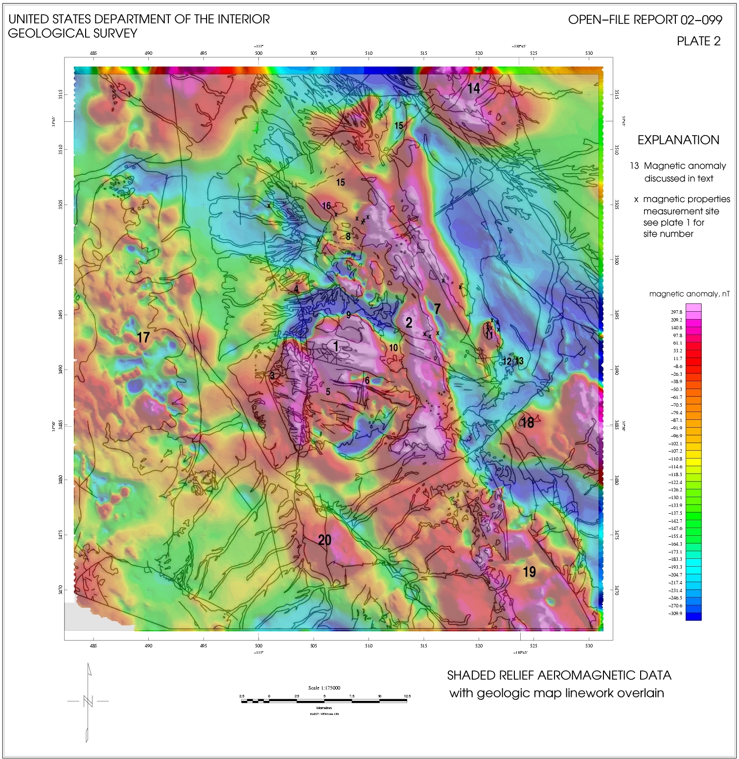
In this report, the terminology "reversely polarized" or similar terms will be used to describe magnetization directions which are other than in the direction of the present day magnetic (induction) field. This includes directions which are other than anti-parallel to the present day field, such as in a magnetic east or west direction. Rock magnetization directions that are along or nearly along the present day field direction will be termed "normally polarized" or with a similar term. The measurements show that rocks of several ages are reversely polarized, and this is borne out by examination of the aeromagnetic map (pl. 2). The Squaw Gulch granite batholith (Drewes, 1971; unit Jg at sites 4 and 5 on pl. 1; area around no. 7 on pl. 2) of Jurassic age is reversely polarized and forms the basement for much of the central part of the map area. Upper Cretaceous dacite flows and tuffs of the lower member of the Salero Formation (Drewes, 1971; unit Krt on pl. 1 at site 3; area around no. 8 on pl. 2) are reversed while the upper welded tuff member is normally polarized (pl. 1 at site no. 2). The upper Cretaceous Josephine Canyon diorite (Drewes, 1971; Kj on pl. 1 at site 6; no. 2 on pl. 2) is younger (about 65 Ma) and is normally polarized. This rock has a strong remanent magnetization as well as a large susceptibility and is responsible for many of the strong positive magnetic anomalies in the study area. The Gringo Gulch pluton (Drewes, 1971; unit TKg on pl. 1 at sites 8-10; no. 11 on pl. 2) is slightly younger (Lower Paleocene, Vugteveen and others, 1981) and is normally polarized, but contains a reversely polarized late phase microgranodiorite (also reported in Hagstrum, 1994). Both the Josephine Canyon diorite and the Gringo Gulch pluton are part of the Laramide magmatic episode that resulted in many diorite and granodiorite intrusions in southeast Arizona (Dickinson, 1989). Many of these intrusions are associated with the porphyry copper deposits of southeast Arizona
[Map unit symbols and formation names refer to units on geologic maps by Drewes (1971, 1980) and Simons (1974). UTM northing and easting are Universal Transverse Mercator coordinates for zone 12N for the sample site. N is the number of susceptibility measurements on different areas of the outcrop at each site. Abbreviations in Remanent Polarity describe directions very different from normal or reversed, for example, "flat90dEoMN" means "flat (horizontal) 90 degrees east of magnetic north"; na, not available. Sample ID refers to the sample location plotted on Plate 1. The last 20 sites in the table were measured only for susceptibility and the maximum and minimum values are given in addition to mean and standard deviation. The instrument used for these sites was a KT-6 Kappa meter, with similar accuracy and precision to the SI-1 described in the text but measuring a smaller volume of rock, about 500 cc.] |
Map unit |
Lithology |
UTM Easting (m) |
UTM Northing (m) |
Altitude |
Mean
magnetic |
Standard |
N |
Remanent |
Remanent |
Sample ID |
Tgd_a |
agglomerate |
501154e |
3505133n |
3665f |
2.99e-4 |
1.88e-4 |
15 |
N |
weak |
1 |
Ksw |
Salero welded tuff |
505871e |
3501793n |
4265f |
7.80e-4 |
1.16e-4 |
5 |
N(flat90dEoMN) |
moderate |
2 |
Kse |
Salero megabreccia |
506995e |
3501570n |
4386f |
1.39e-5 |
1.74e-6 |
5 |
R(flat90dWoMN) |
very weak |
3 |
Js |
Squaw Gulch granite |
516383e |
3493614n |
4775f |
9.23e-4 |
1.02e-4 |
5 |
R(steepWoMN) |
moderate |
4 |
Js |
Squaw Gulch granite |
515315e |
3493422n |
4805f |
5.74e-4 |
4.30e-5 |
5 |
R(steepWoMN) |
moderate |
5 |
Kj |
Josephine Canyon diorite |
515652e |
3492991n |
4791f |
2.404e-3 |
2.26e-4 |
5 |
N(60dEoMN) |
strong |
6 |
Tgut |
Gringo Volcanics rhyolite tuff |
521882e |
3493885n |
4433f |
7.14e-6 |
2.52e-5 |
5 |
na |
na |
7 |
Tgm |
micrograndiorite |
520994e |
3494288n |
4627f |
2.75e-3 |
1.13e-4 |
5 |
R |
weak/ moderate |
8 |
Tgm |
micrograndiorite |
520991e |
3494066n |
4453f |
3.63e-3 |
1.60e-4 |
5 |
R |
strong |
9 |
Tgdp |
diorite porphyry |
521085e |
3493771n |
4539f |
2.13e-3 |
3.24e-4 |
5 |
N(flat) |
strong |
10 |
Kbm_w |
Bathtub rhyolite welded tuff |
521393e |
3493766n |
4684f |
9.72e-6 |
2.21e-6 |
5 |
R(upEoMS) |
moderate |
11 |
Kbm |
Bathtub hornblende dacite |
521425e |
3494728n |
4785f |
1.13e-3 |
9.18e-5 |
5 |
? |
? |
12 |
Kbm |
Bathtub gray tuff breccia |
521899e |
3494595n |
4439f |
5.47e-4 |
7.80e-5 |
5 |
? |
? |
13 |
Trp |
Piper Gulch monzonite |
516910e |
3498422n |
5435f |
2.09e-3 |
3.53e-4 |
5 |
? |
? |
14 |
Klp |
Quartz latite porphyry |
518580e |
3497900n |
4721f |
1.26e-5 |
3.02e-6 |
5 |
? |
? |
15 |
Map unit |
Lithology |
UTM Easting (m |
UTM Northing (m |
Altitude (ft) |
Mean
magnetic Susceptibility K, cgs/cc |
Standard deviation |
N |
Minimum |
Maximum |
Sample
ID |
Tuc |
Nogales conglomerate |
479901e |
3513797n |
3595f |
1.05e-04 |
2.40e-05 |
6 |
6.21e-05 |
1.33e-04 |
16 |
Kr |
Rhyodacite welded tuff |
478388e |
3519766n |
3990f |
8.22e-06 |
3.25e-06 |
6 |
3.18e-06 |
1.19e-05 |
17 |
Kr |
Rhyodacite welded tuff |
478288e |
3519813n |
4020f |
5.41e-06 |
3.79e-06 |
5 |
7.96e-07 |
1.11e-05 |
18 |
Kr |
Andesite tuff breccia |
478600e |
3521805n |
4115f |
1.58e-05 |
1.84e-06 |
6 |
1.35e-05 |
1.83e-05 |
19 |
Kr |
Lithic tuff breccia |
478624e |
3521954n |
4127f |
1.17e-05 |
3.25e-06 |
6 |
7.16e-06 |
1.51e-05 |
20 |
Kr |
Lithic tuff breccia |
478613e |
3522026n |
4140f |
1.31e-05 |
2.79e-06 |
6 |
9.55e-06 |
1.67e-05 |
21 |
Kr |
Andesite lava block in bx |
478613e |
3522026n |
4140f |
2.05e-05 |
1.38e-05 |
7 |
5.57e-06 |
3.98e-05 |
22 |
Js? |
Squaw Gulch granite |
507216e |
3504405n |
4785f |
1.04e-03 |
6.38e-04 |
6 |
1.84e-04 |
1.87e-03 |
23 |
Kse |
Salero megabreccia |
507216e |
3504395n |
4785f |
2.47e-05 |
7.85e-06 |
4 |
1.59e-05 |
3.34e-05 |
24 |
Kse |
Salero megabreccia |
507216e |
3504400n |
4785f |
4.64e-05 |
3.87e-05 |
4 |
2.47e-05 |
1.04e-04 |
25 |
Kjd? |
Diabase dike |
507216e |
3504401n |
4785f |
7.33e-04 |
0.00e+00 |
1 |
7.33e-04 |
7.33e-04 |
26 |
Js? |
Squaw Gulch granite |
507216e |
3504410n |
4785f |
2.27e-04 |
1.37e-04 |
4 |
5.97e-05 |
3.41e-04 |
27 |
Keqf? |
Elephant Head quartz monzonite, fine grained dike |
509690e |
3503690n |
5922f |
2.85e-03 |
4.42e-04 |
6 |
2.31e-03 |
3.33e-03 |
28 |
Keqc |
Elephant Head quartz monzonite |
509690e |
3503690n |
5922f |
3.05e-03 |
5.95e-04 |
5 |
2.28e-03 |
3.94e-03 |
29 |
Keqc |
Elephant Head quartz monzonite |
509766e |
3503855n |
6027f |
3.91e-04 |
5.30e-05 |
5 |
3.19e-04 |
4.67e-04 |
30 |
Kj |
Josephine Canyon diorite (float) |
510099e |
3504022n |
6098f |
5.16e-04 |
0.00e+00 |
1 |
5.16e-04 |
5.16e-04 |
31 |
Kj |
Josephine Canyon diorite |
510099e |
3504022n |
6098f |
2.01e-04 |
6.27e-05 |
5 |
1.33e-04 |
2.75e-04 |
32 |
Kj |
Josephine Canyon diorite |
510099e |
3504012n |
6098f |
1.65e-04 |
8.39e-05 |
3 |
7.24e-05 |
2.36e-04 |
33 |
Keqc |
Elephant Head quartz monzonite |
509105e |
3504011n |
5710f |
5.26e-04 |
1.06e-04 |
5 |
3.90e-04 |
6.52e-04 |
34 |
Keqf? |
Elephant Head quartz monzonite, fine grained dike |
509105e |
3504011n |
5710f |
1.96e-03 |
2.63e-04 |
5 |
1.70e-03 |
2.35e-03 |
35 |
| Previous Section | Next Section |

![]() U.S. Department of the Interior |
U.S. Geological Survey
U.S. Department of the Interior |
U.S. Geological Survey
URL: http://pubsdata.usgs.gov/pubs/of/2002/0099/magprop.html
Page Contact Information: GS Pubs Web Contact
Page Last Modified: Wednesday, 07-Dec-2016 19:25:52 EST
