Open-File Report 02–117
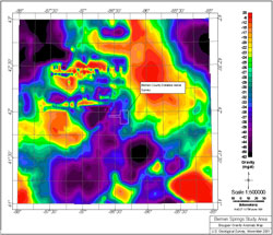
OVERVIEWThis publication includes maps, grids, and flightline databases of a detailed aerial survey and maps and grids of satellite data in Berrien County, Michigan. The purpose of the survey was to map aquifers in glacial terrains. This was accomplished by using a DIGHEMVRES mufti-coil, mufti-frequency electromagnetic system supplemented by a high sensitivity cesium magnetometer and 256-channel spectrometer. The information from these sensors was processed to produce maps, which display the conductive, magnetic and radioactive properties of the survey area. A GPS electronic navigation system ensured accurate positioning of the geophysical data. This report also includes data from the advanced spaceborne thermal emission and reflection (ASTER) radiometer. ASTER measures thermal emission and reflection data for 14 bands of the spectrum. DataThe following list provides the file names and brief descriptions of the databases provided. These databases are located in the data directory as a compressed archive.
Also included in the data directory are the ASCII XYZ files, the GRD files, and a georeferenced TIFF file, all compressed. Data ProcessingA detailed aerial survey denoted as the Berrien County Study Area was flown under contract to the U.S. Geological Survey in October of 2000. Most of the data processing and map preparation was done using Geosoft/Oasis software. The materials from the original CD consist of setup files for viewing with the Oasis montaj free viewer, data files in Microsoft Cabinet format, and supporting HTML documentation (including the contractor's report) and are located in the archive directory. The survey was flown with east-west and north-south flightlines spaced at about 320 m. The nominal altitude of the helicopter was 60 m above the ground. The survey equipment included instruments to measure electromagnetic, magnetic and gamma-ray data. The electromagnetic sensors were located in a "bird" towed at a nominal survey altitude of 30 m above the ground. The data were processed by the contractor to produce apparent resistivities and depths for each of five frequencies. These calculated data were processed by the U.S. Geological Survey to eliminate data where obvious interference from power lines was present in the power-line monitor channels. |
First posted August 21, 2009
For additional information contact: Part or all of this report is presented in Portable Document Format (PDF); the latest version of Adobe Reader or similar software is required to view it. Download the latest version of Adobe Reader, free of charge. |
Duval, J.S., Pierce, H.A., Daniels, D.L., Mars, J.C., Webring, M.W., and Hildenbrand, T.G., 2002, Aerial magnetic, electromagnetic, and gamma-ray survey, Berrien County, Michigan: U.S. Geological Survey Open-File Report 02-117, 1 CD-ROM.

![]() U.S. Department of the Interior |
U.S. Geological Survey
U.S. Department of the Interior |
U.S. Geological Survey
URL: http://pubsdata.usgs.gov/pubs/of/2002/of02-117/index.html
Page Contact Information: USGS Publications Team
Page Last Modified: Wednesday, 07-Dec-2016 19:21:54 EST
