| |  |  | | Lake Pontchartrain Atlas: | | | | | | | | | | | | | | | | | | | | | | | | | | | | Biological Resources |  | | | | | | | | | | | | | | | | |  | | | | | | | | | | |  | Biological Resources - Submersed Aquatic Vegetation Contributors: Cho, Poirrier Changes in Submersed Aquatic Vegetation Distribution and Areal Cover SAV provides food and habitat for estuarine organisms and is an excellent indicator of water quality. Until 1999, SAV in Lake Pontchartrain had been in a state of decline. Early studies by Suttkus et al. (1954) described SAV distribution on the north shore as a continuous meadow that extended out to a depth of 2.0 m (6.6 ft). They also reported SAV to be abundant on the south shore. The abundance of SAV has declined since then. It decreased by 25-35 % between 1954 and 1973 (Turner et al., 1980), 50 % between 1973 and 1984 (Mayer, 1986) and 17 % between 1985 and 1992 (Burns et al., 1993). Shoreline modification, increased water turbidity and macroalgal overgrowth have contributed to this decline. Despite the declining trend, a resurgence of SAV occurred in 1999 that challenged historic levels. Lake-wide shoreline surveys were conducted in 2000 to quantify this increase. The area between the shoreline and a depth of 2.0 m (6.6 ft) was surveyed by cruising with a small boat and snorkeling. North shore SAV was abundant and continuous. Ruppia maritima was the most abundant species (Figure 6). By 2000, it expanded to west of Tchefuncte River on the north shore and on the south shore a bed was present in eastern Jefferson Parish. These areas represent the western most range of Ruppia ever reported from Lake Pontchartrain. On the south shore, Ruppia was abundant near Lincoln Beach and scattered beds occurred west to the Jahncke Canal with a few beds between the canal and the Lakefront airport. Correcting for patchiness, the estimated SAV coverage in 2000 was 150 ha (370.7 acres) of Ruppia maritima plus 12 ha (29.7 acres) of Vallisneria americana. Total SAV habitat was about 450 ha (1112.0 acres). This was greater than the 88 ha (217.4 acres) of actual SAV coverage reported by (Burns et al.,1993) and the 375 ha (926.6 acres) of SAV habitat reported by Mayer (1986), but less than the 810 ha (2001.5 acres) reported by Montz (1978). In spite of the Ruppia increase, Vallisneria continued to decline. It is not known whether the increase in Ruppia is a short-term response to a temporary increase in water clarity caused by a severe drought or a long-term increase due to improved environmental quality. 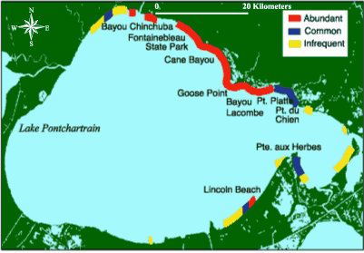 | | Figure 6: Distribution of submersed aquatic vegetation with study areas listed (SAV) in 2000. Abundant: SAV foliage covered at least 30% of the grassbed area Common: SAV foliage covered approximately 10 to 30% of the grassbed area Infrequent: SAV foliage covered at most 10% of the grassbed area | Changes in Species Composition Until 1999, Vallisneria americana had been the dominant SAV species, followed by Ruppia maritima. Other less abundant species present include Najas guadalupensis, Eleocharis parvula and Potamogeton perfoliatus (Montz, 1978) and Myriophyllum spicatum and Zannichelia palustris (Mayer, 1986). Based on our 1996-2000 surveys, Vallisneria americana has continued its state of decline, and in 1999 Ruppia maritima increased to become the most abundant species. Myriophyllum spicatum is still present in the southeastern part of the Lake, but Najas guadalupensis, Eleocharis parvula, Zannichelia palustris and Potamogeton perfoliatus were not found in 1999 and 2000 surveys. The increase in Ruppia and the decline in other species appear to be related to the increased salinity from the drought which began in the fall of 1998. We expect Ruppia abundance to decrease when salinity and water clarity decrease with the return to normal weather patterns. This may result in low total SAV coverage if Vallisneria beds continue to decline. 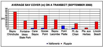 | | Figure 7: Average SAV cover on a transect for each study area, September, 2000. | « Previous | Next » |
