Biological Resources - Submersed Aquatic Vegetation Contributors: Cho, Poirrier Introduction Annual surveys to quantify the abundance of Lake Pontchartrain SAV were made using the line-intercept method (Cho and Poirrier, 2000b) at Pointe aux Herbes, Bayou Lacombe, Goose Point and three sites near Fontainebleau State Park during late summer and fall of 1996 through 1999 (Figure 1). The number of survey sites was changed in 2000 by omitting two sites at Fontainebleau State Park and adding Bayou Chinchuba, Cane Bayou, Lincoln Beach, and Points Platte and du Chien. 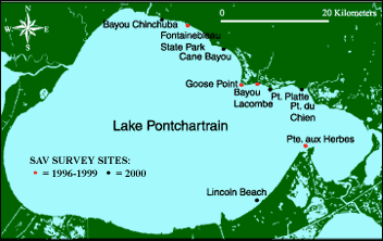 | | Figure 1: SAV survey site location map for Lake Pontchartrain. | 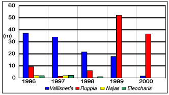 | | Figure 2: Relative abundance of four SAV genera for the years 1996 - 2000. | A Myriophyllum spicatum bed that was present near the mouth of Bayou St. John was also monitored before and after the 1997 Bonnet Carré Spillway opening. Additional SAV surveys were done in the fall of 1998 to determine the effects of Hurricane Georges and the spring of 1999 to document a major increase in SAV. Monthly measurements of temperature, salinity, dissolved oxygen, pH and photosynthetically active radiation (PAR) were made at Pointe aux Herbes, Bayou Lacombe, Bayou St. John and two of the Fontainebleau sites (Figure 3). Surface algal blooms and epiphytic algal growth were also monitored during and after the Spillway opening. The 1997 Bonnet Carré Spillway Opening Based on a comparison of 1996 and 1997 SAV surveys, the March 1997 Bonnet Carré Spillway opening caused a statistically significant decrease in Ruppia maritima, but not Vallisneria americana (Figure 2). The maximum depth at which SAV occurred decreased to 1.0 m (3 ft) at all sites, and the Bayou St. John Myriophyllum bed disappeared in June 1997. Short-term stress on SAV was caused by brackish water being replaced by more turbid Mississippi River water. Also, plant nutrients introduced with River water caused cyanobacterial blooms and increased growth of the filamentous green alga Cladophora on Ruppia and Myriophyllum. Phytoplankton blooms decreased the amount of light reaching SAV. Cladophora overgrowth on Ruppia appeared to make it more susceptible to uprooting by wave energy. Large surface mats of Cladophora, increased turbidity from phytoplankton blooms and anoxic conditions from algal decomposition eliminated the Bayou St. John Myriophyllum bed. When results from the 1997 and 1998 surveys were compared, there was no overall change in Vallisneria except for a decline at Goose Point, but there was a significant increase in Ruppia. Based on an average for all sites, the Ruppia foliar coverage on a 200 m (656 ft) transect was 6.8 m (22.3 ft) in 1996, 0.9 m (3.0 ft) in 1997 and 4.1 m (13.5 ft) in 1998. Although Ruppia increased between 1997 and 1998, recovery to 1996 levels, prior to the Bonnet Carré Spillway opening, did not occur. Data from 1998 did not indicate any major increases in SAV that could be attributed to the 1997 Spillway opening (Cho and Poirrier, 2000). Hurricane Georges in 1998 There was no major short-term change in SAV distribution or abundance that could be attributed to the direct effect of Hurricane Georges, which passed through the area in September 1998. A comparison of an August 1998 SAV survey prior to the passage of the hurricane with an October 1998 survey after the passage did not indicate any statistical differences. However, SAV growing in shallow water, depth of 0.5 m (1.6 ft) or less, was reduced significantly in October surveys due to the disturbance by increased wave energy during the storm. Increased Salinity and Water Clarity Due to 1998-2000 Drought Higher salinity has persisted from the fall of 1998 to the preparation of this manuscript (November 2000) (Figure 4). More saline water was introduced into Lake Pontchartrain with the passage of Hurricane Georges and drought conditions have occurred in the Lake Pontchartrain watershed since then. A comparison of salinity and photosynthetically active radiation (PAR) at a depth of 1.0 m (3.3 ft) between 1998, 1999 and 2000 indicates statistically significant higher values in 1999 and 2000 (Figure 5). Other studies have demonstrated a positive correlation between salinity and water clarity in Lake Pontchartrain (Francis et al. 1994). There was an overall 18-fold increase in Ruppia based on combined data from all sites and a 200-fold increase at the three Fontainebleau sites between fall 1998 and fall 1999. The increase in Ruppia appears to be related to the relatively higher salinity and water clarity that occurred in 1999, but other factors such as general restoration efforts, sediment modification, stimulation of seed germination and distribution of propagules may have also contributed to this increase. Ruppia and Vallisneria also extended to the 2-m depth contour (compared to 1-m in previous years) in 1999 due to increased light availability in deep water. 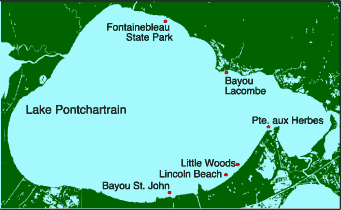 | | Figure 3: Water quality monitoring sites. |  | | Figure 4: Salinity changes over a period of four years for sites along the north and southeastern shorelines of Lake Pontchartrain. | 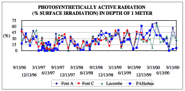 | | Figure 5: Photosynthetically active radiation changes over a period of four years for sites along the north and southeastern shorelines of Lake Pontchartrain. | Low Water Level During Spring and Summer of 2000 Water level during the early summer of 2000 was considerably lower (0.5 -1m) (1.6 - 3.3 ft) than normal due to unusual NW winds. As a result, a large area along the north shore was exposed to air and caused lethal drying of SAV in shallow water. Compared to 1999, there was a 92% decrease in Vallisneria and a 30% decrease in Ruppia (Figure 2). « Previous | Next » | 