| |  |  | | Lake Pontchartrain Atlas: | | | | | | | | | | | | | | | | | | | | | | | | | Basin Geology |  | | | | | | | | | | | | | | | | | | | |  | | | | | | | | | | |  | Basin Geology - Bathymetry Contributors: Connor, Jr., Maygarden, Cardias, Penland, Kindinger A partnership between the University of New Orleans Coastal Research Laboratory (UNOCRL) and the USGS was formed in 1998 to collect hydrographic data along the south shore of Lake Pontchartrain to document bathymetric change since the early 1900's. The collected hydrographic data was processed and computer generated to create a bathymetric map. The hydrographic tracklines span approximately 19 km. (11.8 mi.) in the west-east direction (from the west Bonnet Carré Spillway levee to South Point), and approximately 2-3 km.(1.2-1.9 mi) in the north/south direction (Figure 36). The tracklines run along the south shore of Lake Pontchartrain in an effort to capture bathymetric change since the 1930's. In 1930, the New Orleans Lakefront land reclamation project was completed by the New Orleans Levee Board. This project engineered the creation of 2,000 acres of land, spanning 8.9 km (5.5 mi) from the West End to the Industrial Canal. City surveyor W.H. Bell formulated the first proposal for developing the south shore of Lake Pontchartrain, addressing the "back door" threat of flooding from Lake Pontchartrain. The wetlands that comprised the natural shoreline of the Lake were subject to frequent flooding during periods of high tide, seasonal frontal systems or hurricane winds. Upon completion of the project, billions of cubic yards of lake bottom material had been hydraulically deposited behind a bulkhead to elevations of 0.6-2.4 m (2-8 ft) above sea level. The bulkhead was then replaced by a concrete seawall. The new land along Lake Pontchartrain now contains five residential areas, a state university, a municipal airport, public parks and a scenic parkway. The Lakefront land reclamation project left deep dredge holes along the shoreline. Historic bathymetric data show that these holes were more than 3.0 m (10 ft) deep (Figure 37). The current hydrogaphic survey indicates that the depth has been reduced to around 1.8m (6 ft) with natural re-working of bottom sediments by wave action. 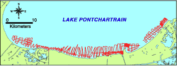 | | Figure 36: Bathymetric trackline map of the south shore of Lake Pontchartrain. | 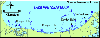 | | Figure 37: Bathymetric contour map of the south shore of Lake Pontchartrain. | « Previous | Next » |
