| |  |  | | Lake Pontchartrain Atlas: | | | | | | | | | | | | | | | | | | | | | | | | | Basin Geology |  | | | | | | | | | | | | | | | | | | | |  | | | | | | | | | | |  | Basin Geology - Quarternary Framework Contributors: Flocks, Manheim, Marot, Willard Recent sediment accumulation within Lake Pontchartrain reflects regional geomorphology. Since the Basin is isolated from the Mississippi and Pearl Rivers, sediment input to the Lake is relatively low and predominantly fine grain. Figures 7 and 8 show recent sediments in the Lake to be primarily clays and silts with some localized sand accumulations due to reworking of relic barrier island trends. 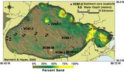 | 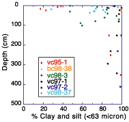 | | Figure 7: Map showing grain size distribution of surficial sediments and vibracore locations in Lake Pontchartrain. Click on the image for a larger version. | Figure 8: Grain-size analysis of vibracores shown in Figure 7 indicate an increase in percentage of clay and silts down core. | Figures 9 and 10 show sediment accumulation rates based on isotope geochronology obtained from sediment samples. The contours indicate that recent accumulation predominates in the central portion of the Lake which is consistent with water circulation trends (see Processes of Lake Pontchartrain Circulation, Wind-induced Lake Circulation Patterns (N, S, E, W), and Wind-induced Lake Circulation Patterns (NW, NE, SW, SE)). 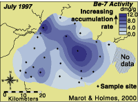 | | 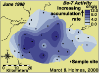 | | Figure 9: Map showing surficial sediment sample sites and sediment accumulation rates within Lake Pontchartrain during the six months prior to the July 1997 sample collection. Light Blue color indicates less deposition and dark blue indicates more deposition. | | Figure 10: Map showing surficial sediment sample sites and sediment accumulation rates within Lake Pontchartrain during the six months prior to the July 1998 sample collection. Light Blue color indicates less deposition and dark blue indicates more deposition. | An X-radiograph of a boxcore obtained from Lake Pontchartrain shows the surficial sediments to consist mainly of fine-grained material with abundant shell hash and some intact clams (Figure 11). Fine laminations can be seen throughout the core. The shell material was actively mined for commercial use over the past century, an activity that has reworked much of the top meter of sediment. 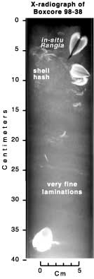 | 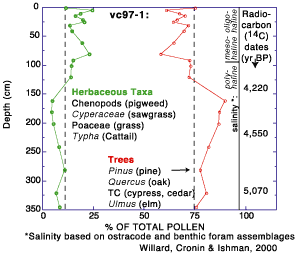 | Figure 11: (left) X-radiograph of Boxcore 98-38 (see location Figure 7) showing in situ positions of the freshwater clam Rangia sp. and very fine laminations of fine-grain sediments.
Figure 12: (top) Graph showing relative abundances of herbaceous (grass) and aboreal (tree) pollen, salinity, and radiocarbon dates. | Sediment mixing has made it difficult to obtain biological or temporal stratigraphy. Nonetheless, some downcore depositional trends still remain in the sediments. Figure 12 shows a shift in the relative abundances of herbaceous (grass) and arboreal (tree) pollen in the upper meter of sediment. This decrease in tree pollen is possibly related either to mid-Holocene climatic change or human development of the surrounding land. The trace metal profiles to 1 m depth show relatively steady downcore concentrations of lead (Pb), copper (Cu) and zinc (Zn) relative to iron (Fe) in sediment cores 97-1 and 97-2, which is indicative of sediment mixing (Figure 13). Despite the homogeneity in the upper meter, it is evident from the chemical constituents, palynology, and isotope measurements that between 50 and 140 cm there is a transition from recent sediment accumulation and sediments deposited thousands of years ago (Flocks and others, in press). Core 95-1 shows surficial increases in the trace metal constituent, suggesting this core has escaped the same degree of mixing. The higher concentrations may reveal input of contaminant related material to the Lake. Increased sand percent in the surface sediments of this core do not dilute the trace metal fraction. This would suggest active deposition of anthropogenic material in this area. 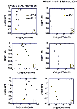 | | Figure 13: Trace metal profiles from vibracores. Graphs A, C, and E are from vibracores vc97-1 and vc97-2; Graphs B, D, and E are from vibracore vc95-1. Graphs A and B show the ratio of Pb (parts per million [ppm] - lead) to Fe (percent weight [wt%] - iron); Graphs C and D show the ratio of Cu (ppm - copper) to Fe (wt% - iron); and Graphs E and F show Zn (ppm - zinc) to Fe (wt% - iron). | « Previous | Next » |
