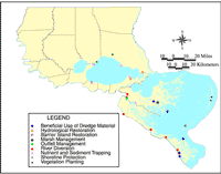
| |  |  | | Lake Pontchartrain Atlas: | | | | | | | | | | | | | | | | | | | Restoration |  | | | | | | | | | | | | | | | | | | | | | | | | | |  | | | | | | | | | | |  | Restoration - Restoration of the Lake Pontchartrain Basin Contributors: Penland, Maygarden, Lake Pontchartrain Basin Foundation The Pontchartrain Basin Restoration Act of 2000 is authorized at $20 million per year as a regional effort to support the environmental restoration activities of the LPBF, UNO and the Regional Planning Commission (RPC) of Jefferson, Orleans, Plaquemines, St. Bernard and St. Tammany Parishes. During the next few years this Basin partnership will conduct a watershed analysis to establish an environmental monitoring system, implement restoration programs and construct restoration projects within the LPB watershed. It is intended to provide coordination among the parishes, state and federal government, as well as private foundations and universities in a comprehensive restoration effort (Figure 21, Table 3). A Memorandum of Understanding (MOU) was signed by UNO, LPBF and RPC for the implementation of the partnership and a master implementation plan is underway. A key outcome of the watershed approach to Basin management is the development of the Watershed Management Plan (WMP). A WMP is an integrated action plan which contains non-regulatory action items and may contain recommended regulatory activities. The Plan is based on a detailed investigation of watershed characteristics, issues and problems (watershed analysis) and produces a set of goals and objectives based on priority issues. Future actions in the Basin, both regulatory and non-regulatory, should be consistent with the WMP and be designed to achieve plan goals and objectives. The Watershed Management Plan should build upon the issues and concerns identified in the LPB CMP completed in 1990. In the years following the completion of the CMP, numerous studies on water quality, geologic processes, habitat degradation, etc., have been completed in the Basin. However, this work has not been integrated into a systematic watershed management framework, and therefore, it is difficult to adequately assess Basin ecological integrity or to prioritize areas of imminent concern. An essential component of the LPB WMP is, accordingly, a watershed analysis. The partners will develop the watershed analysis using a watershed approach to Basin management. The approach is grounded in an understanding of all the stressors in the watershed including physical, chemical and biological factors that may affect the health of the watershed. A strong watershed approach uses sound science, facilitates communication and partnerships, fosters actions that are well-planned and cost effective and stimulates actions and tracks results. Watershed analysis is a procedure used to characterize the human, aquatic, riparian and terrestrial features, conditions, processes and interactions within the watershed. It provides a systematic way to understand and organize ecosystem information. In so doing, watershed analysis enhances our ability to estimate direct, indirect and cumulative effects of our management activities and guide general type, location and sequence of appropriate management activities within a watershed. | River Diversions | There are two main kinds of river diversions: - Controlled Diversions:
- Help relieve saltwater intrusion.
- Introduce sediment and nutrients to promote growth of new marsh.
- Siphons (e.g. Violet, White Ditch)
- River Diversions (e.g. Caernarvon)
- Uncontrolled Diversions: A gap is cut in river levee to create delta-building diversions of river water, promoting the creation of new marsh.
| | Outfall Management | Outfall management is designed to maximize benefit of river diversion projects. Caernarvon Freshwater Diversion project's outfall management determines the times of diversion and the quantity of water diverted as well as ensuring that the fresh water reaches the areas where it is needed. | | Hydrologic Restoration | Hydrologic restoration projects aim to restore more natural hydrologic conditions where human-induced changes have damaged wetlands. Bayou Savage, Hopedale and Fritchie Marsh are sites of hydrologic restoration. | | Marsh Management | Marsh management employs structures to control the water levels within impounded areas of marsh. One marsh management project is working to maintain an area of perched fresh marsh in the St. Bernard Wetland Area. | | Shoreline Protection | Various structural methods are used to decrease or halt shoreline erosion. These include rock berms, segmented breakwaters and wave-dampening fences. The shoreline of Lake Pontchartrain at the LaBranche Wetlands and Manchac Wildlife Management Area are protected using these methods. | | Barrier Island Restoration | Methods used to restore the barrier islands include placement of dredged material to increase the height and width of the islands, as well as vegetative planting and sand-trapping fences to stabilize sediment. Dredged sediment is pumped onto Breton Island in the south Chandeleur Islands to restore and maintain the island. | | Beneficial Use of Dredge Material/Marsh Creation | The use of material dredged during maintenance of navigation channels and canals is placed in deteriorated wetland areas to create new marsh. Examples of beneficial use of dredged material include those at Baptiste Collette and Pass à Loutre in the Birdfoot Delta and along the MRGO. At the LaBranche Wetlands, a marsh creation project used dredged material from the floor of Lake Pontchartrain to create 350 acres of new marsh. | | Sediment and Nutrient Trapping | Examples of sediment and nutrient trapping projects include Christmas tree fences and terraces. Christmas tree fence project locations include the LaBranche Wetlands, Manchac, Big Branch Wildlife Refuge and the Caernarvon outfall area. | | Vegetation Planting | This technique involves planting native wetland vegetation to stabilize and hold together sediment. Planting projects are often used in conjunction with shoreline protection, barrier island restoration, sediment trapping, marsh creation and beneficial use of dredged material projects. Planting projects currently underway include grass planting on the north Chandeleur Islands. There are also planting projects near Pass Manchac and in St. Tammany Parish. | |
Table 3: Methods and examples of coastal restoration in the Lake Pontchartrain Basin (source: CWPPRA and Coast 2050). « Previous | Next » |