| |  |  | | Lake Pontchartrain Atlas: | | | | | | | | | | | | | | | | | | | Restoration |  | | | | | | | | | | | | | | | | | | | | | | | | | |  | | | | | | | | | | |  | Restoration - Restoration of the Lake Pontchartrain Basin Contributors: Penland, Maygarden, Lake Pontchartrain Basin Foundation In 1989, the public voiced support of coastal restoration by voting to approve the Wetlands Trust Fund, which dedicated $25 million per year of state revenues to restore Louisiana's troubled coastal zone. In 1990, Congress authorized the CWPPRA, which provides an additional $35 million per year of federal funds to coastal restoration and created an interagency task force charged with developing a "comprehensive approach to restore and prevent the loss of coastal wetlands in Louisiana." The Wetlands Trust Fund provides the required 25% state match. Throughout the CWPPRA process, the public has provided critical input into restoration goals, strategies and plan implementation. Another key component of CWPPRA is the development of a Coastal Wetland Conservation Plan (CWCP) by the state. The aim of the CWCP is to achieve "no net-loss" of coastal wetlands as a result of development activities. In an effort to reverse Louisiana's long-term coastal land loss trend, effective large-scale and small-scale restoration projects with a high degree of potential success must continue to be implemented. These include: - Vegetative planting to buffer erosion (Figure 16).
- Barrier island and shoreline restoration to protect against storms.
- Sediment and freshwater diversions to nourish deteriorated marshes (Figures 17, 18, 19, and 20).
- Hydrologic restoration to re-establish fresh water flow patterns. Projects must be monitored to assure that the intended benefits are achieved. Additionally, projects that demonstrate new and innovative restoration techniques must be approved.
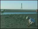 | | 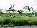 | | Figure 16: UNO Coastal laboratory staff monitoring vegetation planting project, Chandeleur Islands. Click on the image for a larger version. | | Figure 17: Brown Pelicans and Laughing Gulls on Plover Island, created with dredged material from Baptiste Collette Bayou, Birdfoot Delta (USACE). Click on the image for a larger version. | 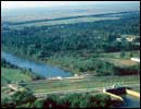 | 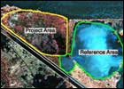 | 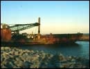 | | Figure 18: Caernarvon freshwater diversion structure and outfall area, Plaquemines Parish. Click on the image for a larger version. | Figure 19: Satellite image of LaBranche wetlands marsh creation project (CWPPRA). Click on the image for a larger version. | Figure 20: Shoreline armoring operation, LaBranche wetlands. Click on the image for a larger version. | Since 1994, 15 CWPPRA projects have been implemented in the Lake Pontchartrain Basin (Table 2, below). The types of projects implemented range from hydrologic restoration, barrier island restoration, diversion outfall management, wetland terracing, vegetative plantings, dedicated dredging and more. | Project Number | Project Name | Project Area | Acres Created/
Restored | Acres Protected | Total Net Acres* | | XPO-55a | Opportunistic Use of Bonnet Carré Spillway | 13,583 | | 177 | 177 | | XPO-95 | Chandeleur Islands Restoration | 504 | 220 | | 220 | | PPO-7a | LaBranche Wetlands Terracing/Plantings | 4,505 | 374 | 115 | 489 | | PPO-38 | Hopedale Hydrologic Restoration | 3,805 | | 134 | 134 | | XPO-74a | Bayou Bienvenue Pump Station/Terracing | 2,661 | 415 | 27 | 442 | | PBS-1 | Upper Oak River Freshwater Introduction | 4,618 | 270 | 69 | 339 | | PMR-10 | Delta-wide Crevasses | 5,210 | 2,298 | 88 | 2,386 | | XPO-69 | Bayou Chevee Marsh Creation (Revised) | 212 | | 75 | 75 | | XPO-71 | MRGO Back Dike Marsh Protection | 855 | | 755 | 755 | | XMR-10 | Channel Armor Gap Crevasse | 2,097 | 611 | 325 | 936 | | PO-52a | Bayou Sauvage NWR Hydrologic Restoration (Phase II) | 3,800 | 1,050 | 500 | 1,550 | | PO-6 | Fritchie Marsh Restoration | 5,924 | | 1,040 | 1,040 | | BS-3a | Caernarvon Diversion Outfall Management | 15,556 | 802 | | 802 | | PO-52A | Bayou Sauvage NWR Hydrologic Restoration (Phase I) | 3,800 | 1,050 | 500 | 1,550 | | PPO-10 | Bayou LaBranche Marsh Creation | 487 | 203 | | 203 | | PPO-4 | Eden Isles East Marsh Restoration | 2,536 | 1,454 | | 1,454 | | PMR-9b | Pass à Loutre Crevasse | 1,869 | 1,043 | | 1,043 | | TOTAL | 13,595 | | * | All figures are those published at time of project approval by the CWPPRA Task Force as per the Priority Project List (PPL) Reports and do not include project revisions since that time unless otherwise noted. | | Project Area | = | The benefitted area as determined by the Environmental Work Group for purposes of conducting Wetland Value Assessments. | Acres Created/
Restored | = | The acres of emergent marsh created or restored as a result of project implementation. | | Acres Protected | = | The acres of emergent marsh protected as a result of project implementation. | | Total Net Acres | = | The net gain in emergent marsh as a result of project implementation as determined by the Environmental Work Group. This figure includes acres of emergent marsh protected, created and restored as a result of project implementation. | | Table 2: CWPPRA projects located in Lake Pontchartrain Basin (source: CWPPRA web site at http://www.lacoast.gov/CWPPRA/projects/pontchartrain/). « Previous | Next » |
