1Geological Survey of Canada
3303 33rd St NW
Calgary, AB, Canada, T2L 2A7
Telephone: (403) 292-7141
Fax: (403) 292-7071
e-mail: pdavenpo@nrcan.gc.ca
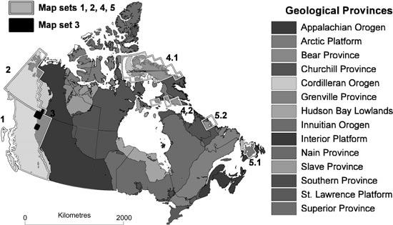
Figure 1. Location and geological setting of map sets used in project to develop a bedrock geology map database for Canada. |
Set 1. This map set comprises 88 map tiles compiled by the Geological Survey of British Columbia (BCGS) at a scale of 1:250,000 as a base for a mineral potential assessment of the entire province. Map sheets have been edge-matched, and a provincewide legend applied to the whole set.
Set 2. The Yukon map set includes approximately 90 maps whose original line work was digitized and synthesized into a digital compilation that was released on CD-ROM for the whole territory by Gordey and Makepeace (1999). In contrast to set 1, map features remain linked to their original map sources, and scale of mapping ranged from 1:250,000 (or less in a few cases) to 1:50,000. The compilers concentrated on fitting individual source legends into a regional legend for the whole area, and adjusting some map features across map boundaries. The varying resolution of the source maps resulted in variable levels of detail in the final compilation. Little original information has been lost in the compilation process, and the compilers' changes are identified as such. Together, map sets 1 and 2 cover the entire Canadian Cordillera and the western margin of the Interior Platform.
Set 3. This map set consists of nine 1:50,000 digital geological maps and one 1:250,000 map that was digitized and released by the Geological Survey of Canada in GIS (ArcView) format as part of the ongoing Central Forelands NATMAP project (http://www.nrcan.gc.ca/gsc/calgary/majorprojects/central_e.html). The 1:50,000 maps are the most recent detailed mapping for this part of northern British Columbia and Yukon and will be used to update the BCGS and Yukon map sets.
Sets 4.1 and 4.2. There are two map sets for Nunavut, all for Baffin Island, which lies within the Churchill Province and Arctic Platform. Set 4.1 is being digitized by the Nunavut Geoscience Office. These 36 existing 1:250,000 paper maps were published by the Geological Survey of Canada as part of a project to create a digital geological map for the new territory. In addition, seven contiguous 1:100,000 maps (set 4.2) have been prepared by ESS Info (the Earth Science Sector information agency for the Geological Survey of Canada) in ArcInfo format in a pilot project to create a data warehouse of its published geological maps.
Sets 5.1 and 5.2. The final two map sets are from the geological-map database system Geolegend (Colman-Sadd and others, 1997) developed and maintained by the Geological Survey of Newfoundland and Labrador (Colman-Sadd and Crisby-Whittle, 2001). These map sets were digitized from the original source maps at their original scales. Set 5.1 comprises 82 maps for the Island of Newfoundland at scales ranging from 1:15,000 to 1:250,000. These lie within the Appalachian Orogen. Set 5.2 comprises 15 maps for Labrador at scales ranging from 1:50,000 to 1:500,000, covering parts of the Churchill and Nain Geological Provinces. For any particular area, the most detailed and recent information has been used, and the goal is to have provincewide coverage. The database also is maintained to reflect the results of new mapping and other research (such as radiometric dating) as they are published.
Geomatter II (Boisvert and others, 2001) has been used as a graphical user interface for populating and organizing the NADM tables. Some tables are also loaded directly from spreadsheets, but Geomatter is used to verify the results of the bulk loading and to make any minor corrections. Geomatter II has been modified during the project as the database structure has evolved and works with both the Access and Oracle versions of NADM.
The multi-agency nature of CGKN dictates that the data and information of each participating survey is maintained locally, while the need to deliver consistent information across agencies requires the adoption of common standards and protocols for coordinating the way it is organized. This distributed nature of the project poses problems in coordinating concept trees between several databases, especially since there will be differences in the details of the information to be stored in each. A way to allow local diversity while maintaining overall consistency has been proposed (Boisvert and others, 2001) through a central database (or registry) of concepts that are identified as being nationally important. This central concept registry will mediate between clients and the distributed databases to present a nationally consistent interface. The distributed databases will be able to accommodate local needs with a minimum of external constraints and allow them to be accessed directly.
Table 1. Map-unit levels as an idealized hierarchy,
and appropriate display scales for each level.
| Map-unit type |
Approximate display scale |
||
|---|---|---|---|
| Geological Province | ≤1:25,000,000 | ||
|
Tectonic Terrane (Cordillera) ≅ Tectonic Zone (Appalachians) |
1:10,000,000 | ||
| Tectonic Assemblage | 1:1,000,000 | ||
| Supergroup (Super Suite) | ≥ 1:250,000 | ||
| Group (Suite, Complex) | ≥ 1:250,000 | ||
| Formation (Lithodeme) | ≥ 1:250,000 | ||
| Member | ≥ 1:250,000 | ||
| Source-map unit (informal) | variable |
There are fundamental problems with this idealized hierarchy as an entity, however, in particular between the upper part (Geological Province, Tectonic Terrane) and the lower part (the Lithostratigraphic/Lithodemic hierarchy). "Geological province" is defined as "an extensive region characterized throughout by similar geologic history or by similar structural, petrographic, or physiographic features" (Jackson, 1997). A lithostratigraphic unit is "a defined body of sedimentary, extrusive igneous, metasedimentary, or metavolcanic strata that is distinguished and delimited on the basis of lithic characteristics and stratigraphic position" (Jackson, 1997), while a lithodemic unit is "a defined body of predominantly intrusive, highly deformed, and/or metamorphosed rock, distinguished and delimited on the basis of rock characteristics" (North American Commission on Stratigraphic Nomeclature, 1980). Thus, Geological Provinces are defined and distinguished not only by the bodies of rock they contain, but also by their structural history.
Tectonic Terranes, like Geological Provinces, "are parts of the earth's crust which preserve a geological record different from those of neighbouring terranes" (Gabrielse and others, 1992), and are thus defined on more than one criterion. Tectonic Assemblages are comparable in most respects to lithostratigraphic/lithodemic units. A Tectonic Assemblage is defined as a grouping of lithostratigraphic units that is "commonly bounded by regional unconformities or by faults [and] represents a specific depositional or volcanic setting and/or response to one or more tectonic events"; "each tectonic assemblage reflects a specific tectonic and/or depositional environment regardless of its place of origin." A specific assemblage may belong to two or more Terranes that differ in their history of deformation. Some source units in the Yukon map set also have been split among two or more assemblages.
The variation in criteria used for each classification type leads inevitably to multiple inheritance problems when one attempts to impose a simple hierarchy. Instead of defining a hierarchy for the map-unit types as a COA tree, the spatial classification, classification object, and classification scheme tables are used to classify the source-map units into the various levels by individual spatial feature (polygon). Specifically, each source-map polygon must be individually assigned to each of the higher levels in the spatial classification table (as Gordey and Makepeace, 1999, had done in their compilation). For other maps, this will entail more work during loading because with a simple hierarchy, each unit at the lowest level (i.e., the original units on the source maps) has only to be related to its immediate parent to be placed correctly in the hierarchy.
The above discussion applies mainly to the stratified rocks that form the lithotectonic framework of a region. Plutonic rocks, which are typically considered apart from the stratified rocks, generally can be grouped into major pulses of magmatism. Metamorphic rocks may either be included in the lithostratigraphic units, or, in some cases where they are of uncertain affinity, they may be grouped into an "unassigned" category. Finally, postorogenic lithostratigraphic units commonly may be grouped into larger assemblages based on criteria such as regional unconformities. These groupings of plutonic, metamorphic, and postorogenic lithostratigraphic units provide ways to aggregate them into more general categories that serve as the equivalents to Tectonic Assemblages and Tectonic Terranes for the purpose of map scaling.
Table 2. Hierarchy developed for map units in the portion
of the Yukon map set northeast of the Tintina Fault. "Source
units" are original map units that are uniquely identified by their
original label and a source-map ID. "Regional unit" and "Regional
subunit" are groupings of source units developed by Gordey and
Makepeace (1999).
| COA_Name (map unit type) |
Number of classes |
||
|---|---|---|---|
| Geological Province | 2 | ||
| Tectonic Terrane | 17 | ||
| Tectonic Assemblage | 42 | ||
| "Regional unit" | 99 | ||
| (Supergroup, Supersuite) | 2 | ||
| "Regional subunit" | 159 | ||
| Group, Suite, Complex | 43 | ||
|
Formation, Lithodeme (+ informal equivalents) |
161 | ||
| Member (+ informal equivalents) | 21 | ||
| "Source unit" | 2082 |
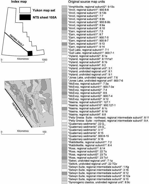
Figure 2a. Examples of changing map resolution based on map-unit level for NTS sheet 105A, NE of Tintina Fault. Original units from source maps, and index map (see Figure 1, map set 2 for location). b. Terranes. |
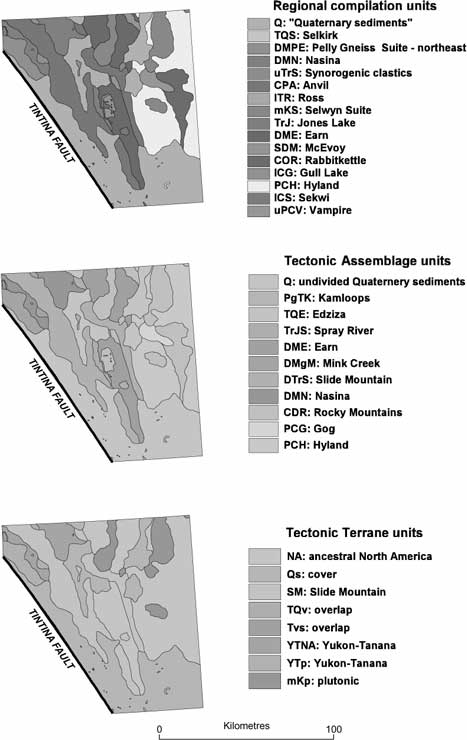
Figure 2b. Examples of changing map resolution based on map-unit level for NTS sheet 105A, NE of Tintina Fault. Top to bottom, the 58 source-map units have been reclassified into 16 regional compilation units, 11 Tectonic Assemblages, and 8 Tectonic Terranes. |
The chronostratigraphic interval assigned to a map unit may be from one of a number of regional systems, and the particular system used in map legends is rarely, if ever, specifically referenced. Despite this uncertainty, map-unit ages can be reconciled in a general way by reference to their currently accepted absolute age ranges. For this purpose in Canada, the geologic time scale compiled and updated periodically by Okulitch (2002) is being employed.
Lithological nomenclature presents similar, but more complex challenges for correlating map units from different sources. There are two main problems. Firstly, rock names are based on one or more of the following properties: genesis, composition, texture, fabric and degree of consolidation or induration; that is, rock names are "multidimensional." Secondly, several common rock names imply different rock properties to different geological communities, and as in the case of chronostratigraphy, usage of these names is rarely defined explicitly. For both these reasons, rock names themselves do not provide a reliable basis for either querying or defining relationships among map units on geological maps from different sources.
The issue of the multidimensionality of rock names has been addressed by attempting to break down each rock name into its implicit properties, building on the proposals of Weisenfluh (2001) and Struik and others (2002). A single rock name such as "siltstone" implies a genesis (a clastic, sedimentary rock), a texture (a sorted rock composed of silt- and clay-sized grains), and an indurated material. A "shale" likewise implies a similar genesis, texture, and degree of induration, but also a fabric, as a shale is implicitly a rock with planar laminations that impart fissility. In some cases, additional information about rock properties is provided by qualifiers; for example, "marine siltstone" provides more information about the rock's genesis, "foliated sandstone" provides information about fabric that is not implicit in the rock name itself.
The way a rock parts is quite commonly described in map legends, such as rock's fissility or blockiness, as well as more specific jointing characteristics. For this preliminary scheme, a simple set of categories has been set up that distinguishes partings along one set of planar surfaces from rocks with two or more sets, and lithologies that are explicitly stated to be structureless.
Resistance to weathering is another mechanical property that commonly is used in map-unit descriptions. Its performance as a standard rock-property index has yet to be tested.
Table 3. Classification of mechanical properties as
implied by rock names used to describe map units. This
scheme is extensible based on the properties of actual map
legends.
| Property | Category | Subcategory | ||||
|---|---|---|---|---|---|---|
| Induration |
1 unconsolidated 2 poorly consolidated 3 consolidated |
|||||
| Weathering |
1 resistant 2 recessive |
|||||
| Parting |
1 multiplanar 2 fissile (single plane) |
1.1 columnar 1.2 blocky 2.1 platy 2.2 flaggy 2.3 slaty |
As assemblages of earth materials, rocks commonly comprise two or more of the first-level compositional groupings (e.g., a calcareous quartz sandstone is predominantly a high-silica silicate rock, but has a lesser, but noteworthy, carbonate component). Thus, a rock can be assigned to one dominant and one or more subordinate compositional categories, all based on a single, simple, qualitative classification.
Table 4. Simple two-level classification of composition as
implied by rock names used to describe map units. This
scheme is extensible based on the properties of actual map
legends.
|
Composition category |
Subcategory | ||
|---|---|---|---|
| 1 Silicate |
1.1 high silica > 65% SiO2 1.2 intermediate silica 53-65% SiO2 1.3 low silica 44-53% SiO2 1.4 very low silica < 44% SiO2 |
||
| 2 Oxide (nonsilicate) |
2.1 ferruginous 2.2 manganiferous |
||
| 3 Carbonate |
3.1 calcic 3.2 magnesian 3.3 barium 3.4 iron |
||
| 4 Sulphate | (subcategories by major cation) | ||
| 5 Sulphide | (subcategories by major cation) | ||
| 6 Halide | (subcategories by major cation) | ||
| 7 Phosphate | (subcategories by major cation) | ||
| 8 Nitrate | (subcategories by major cation) | ||
| 9 Borate | (subcategories by major cation) | ||
| 10 Native element | (subcategories by element/polymorph) | ||
| 11 Carbonaceous |
Genetic Process: The primary level of subdivision for this classifier (Table 5) recognizes the traditional categories Igneous, Sedimentary, and Metamorphic, although the term "metamorphic" is used in its most general sense to mean a protolith that has undergone a mineralogical and/or compositional change, including metasomatism and pedogenesis. This sense follows the preliminary approach of the metamorphic subgroup of the Science Language Technical Team of NADM (Richard, 2002). The second level allows further description of the process in a very general way. The third level has been developed only partially, but other equivalent categories may be added to accommodate the lithological information to be classified in actual map legends.
Table 5. Simple three-level classification of genetic
process as implied by rock names used to describe map
units. This scheme is extensible based on the properties of
actual map legends.
| Category | Subcategory | Sub-subcategory | ||||
|---|---|---|---|---|---|---|
| 1 Igneous |
1.1 explosive 1.2 passive |
|||||
| 2 Sedimentary |
2.1 clastic 2.2 chemical precipitation 2.3 biogenic |
2.2.1 evaporitic 2.2.2 nonevaporitic |
||||
| 3 Metamorphic |
3.1 dynamic (high strain) 3.2 regional (dynamothermal) 3.3 contact 3.4 metasomatic 3.5 pedogenic 3.6 impact |
3.4.1 hydrothermal 3.4.2 deuteric 3.4.3 pyrometasomatic |
Environment of Formation: The other information about a rock's genesis that is commonly implicit is its place of formation relative to the upper surface of the crust. This information is indexed using the three-level classification in Table 6. The first level distinguishes rocks formed on or above the surface of the crust--"supracrustal"--from those formed below--"crust" or "mantle" (it could also be extended to other astronomical bodies using a level above this). The second and third levels provide more detail where this is available. As in other classifications, the third level is not completely developed at present.
Rock names may imply a genetic history rather than a single genesis, so a rock name may be classified against more than one genetic process, each of which may have an associated environment of formation. Thus, a slate would be classified as both "sedimentary, clastic" and "metamorphic, dynamothermal" in terms of genetic process, and "supracrustal, subaqueous" and "crust" as the environments of formation associated with each respective genetic process. No attempt has been made to capture the order of the genetic events.
Table 6. Simple three-level classification of environment
of formation as implied by rock names used to describe
map units. This scheme is extensible based on the properties
of actual map legends.
| Category | Subcategory | Sub-subcategory | ||||
|---|---|---|---|---|---|---|
| 1 Supracrustal |
1.1 subaerial 1.2 subglacial 1.3 subaqueous |
1.3.1 marine 1.3.2 freshwater 1.3.3 intertidal |
||||
| 2 Crust |
2.1 shallow 2.2 deep |
|||||
| 3 Mantle |
Table 7. Five categories for texture as implied by rock names used to describe map units. This scheme is extensible based on the properties of actual map legends.
| Textural Property | Category | Subcategory | Sub-subcategory | ||||||
|---|---|---|---|---|---|---|---|---|---|
| Grain intergrowth |
1 crystalline 1 granular |
||||||||
| Grain-size variability |
1 homogeneous 2 heterogeneous 3 gradational |
||||||||
| Grain size |
1 size class 1 <0.05 mm 2 size class 2 0.05-0.2mm 3 size class 3 >0.2 mm |
3.1 size class 3.1 0.2-2 mm 3.2 size class 3.2 2-4 mm 3.3 size class 3.3 4-64 mm 3.4 size class 3.4 64-256 mm 3.5 size class 3.5 >256 mm |
3.3.1 size class 3.3.1 4-16 mm 3.3.2 size class 3.3.2 16-64 mm |
||||||
| Grain morphology |
1 rounded 2 subrounded 3 angular 4 irregular |
||||||||
|
Large particle to matrix proportions (heterogeneous rocks only) |
1 matrix dominant 2 matrix subordinate |
The classification for texture is:
Table 8a. Classification of physical form--external habit
as implied by rock names used to describe map units. This
scheme is extensible based on the properties of actual map
legends.
| Category | Subcategory | ||
|---|---|---|---|
|
1 Tabular 2 Lenticular 3 Equant |
1.1 thin 1.2 medium 1.3 thick 1.4 very thick |
Internal structures (Table 8b) are grouped under surfaces (both primary and secondary) and volumes (more equidimensional features). Some "lithology strings" may imply more than one surface type or volume type.
Table 8b. Classification of physical features--internal
structures as implied by rock names used to describe map
units. This scheme is extensible based on the properties of
actual map legends.
| Category | Subcategory | Sub-subcategory | |||||
|---|---|---|---|---|---|---|---|
| 1 Surfaces |
1.1 laminated 1.2 cross-stratified 1.3 wavy 1.4 mudcracked 1.5 foliated 1.6 flaser 1.7 sheared |
1.5.1 continuous (schistose) 1.5.2 discontinuous (gneissose) |
|||||
| 2 Volumes |
2.1 amygdaloidal 2.2 boudinaged 2.3 concretionary 2.4 miarolitic 2.5 nodular 2.6 orbicular 2.7 vesicular 2.8 vuggy |
Table 9. Qualitative classification of the proportions of
ithologies in map units from legend descriptions of map
units.
| Proportion label | Description | ||
|---|---|---|---|
| All: | map unit contains only a single lithology | ||
| Major: |
lithologies explicitly described as the main component, or implied to be major where the all other components are stated to be minor |
||
| Significant: |
lithologies are named in the main part of the text without qualification as to their importance |
||
| Minor: |
lithologies explicitly described as minor (or rare) components of the map unit |
In addition to the qualifiers explicitly expressed in the map legend, in some cases an additional qualifier may be inferred from the context of the map unit. For example, the rock name "quartzite" may refer to either a sedimentary or a metamorphic rock, and it is commonly possible to determine which applies from the associated lithologies within the same map unit. The aim is to make each "rock name and associated qualifier" contain all the information that will be needed to classify it as precisely as possible against the generic classifications without further reference to the map-unit description. This speeds up the classification process and ensures that similar strings from different sources are classified identically.
Extracting lithological information from the legend in this way is the slowest step of the process and requires geological knowledge and experience. It is critical to the success of the whole exercise and probably cannot be automated. Although the classifications will be refined over time, if this step is done well, it should not have to be repeated.
When the list of rock names and associated qualifiers was complete for a map set, a list of all the unique combinations was compiled, spelling errors corrected, and "trivial synonyms" caused by variations in spelling or order of qualifiers removed. This edited list was then classified against the thematic indexes, and these classifications related back to the map units. The legend of the next map set was taken through the same process, and the list of unique rock names and qualifiers compared to the first, edited as before, and any new strings added to the set to build up a master list. This list grew rapidly at first, but more slowly as more map sets were processed. This list also allowed an analysis of historical usage of rock names that can be used to suggest a better approach to the process of describing map units for geological map databases in the future.
Table 10. "Root" rock names extracted from 2,311 NE Yukon map-unit descriptions.
| Common rock names | ||||||||||||
|---|---|---|---|---|---|---|---|---|---|---|---|---|
|
agglomerate amphibolite andesite aplite arenite argillite arkose ash basalt bentonite biocalcarenite blastomylonite calcarenite calcirudite chert clay clayrock claystone clinopyroxenite coal conglomerate dacite diabase diamictite diatomite diorite |
dolomite dolosiltite dolosiltstone dolostone dunite eclogite felsite gabbro gneiss grainstone granite granodiorite gravel greenstone greywacke grit harzburgite hornblendite hornfels ignimbrite iron-formation ironstone jaspilite latite leucogabbro |
leucogranite lignite limestone marble marl marlstone metachert metaconglomerate metadiorite metagabbro metagreywacke metagrit metaporphyry metaquartzite metarhyolite metasandstone metasiltstone metatuff monzodiorite monzogranite monzonite moraine mudrock mudstone mylonite |
nepheline-syenite orthoconglomerate orthogneiss orthoquartzite packstone paraconglomerate paragneiss pegmatite pelite peridotite phyllite phyllonite porcellanite porphyry protomylonite psammite pyroxenite quartz-diorite quartzite quartz-monzonite quartz-syenite rhyodacite rhyolite sand sandstone |
sandur schist serpentinite shale silt siltrock siltstone skarn spiculite subgreywacke syenite syenodiorite tholeiite till tillite tinguaite trachyandesite trachybasalt trachyte tufa tuff turbidite ultramylonite wacke wackestone |
||||||||
| Mineral names | ||||||||||||
|
anhydrite barite chalcedony gypsum hematite limonite pyrite quartz |
||||||||||||
| Rock class names | ||||||||||||
|
alluvium breccia calc-silicate rocks carbonate rocks clastic rocks colluvium glacial drift igneous rocks intrusive rocks laminate lime-silicate rocks megabreccia metacarbonate rocks metamorphic rocks |
metasedimentary rocks metavolcanic rocks organic deposits phosphate rocks plutonic rocks pyroclastic rocks quartz-carbonate rocks quartzose rocks sedimentary rocks sediments siliciclastic laminates ultramafic rocks volcanic rocks volcaniclastic rocks |
|||||||||||
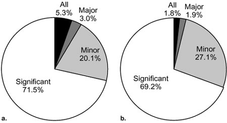
The colour of each lithology also was captured for the legends of the source maps and regional compilation units (colour is little used as a descriptor at the Tectonic Assemblage and Terrane levels). The frequency of association of colours with lithologies decreased from 28% for the source map units to 24% and 17% for the compilers' regional subunits and units, respectively. On closer examination, there are 321 unique colour combinations, ranging from single, simple names (e.g., black, red, white), to those with little specific meaning (e.g., dark or varicoloured), to multi-hued assemblages to describe a single lithology (e.g., light grey to black, greenish grey to turquoise). In short, the descriptions of colours as used in this test map set are too varied to organize in a single database field, although in retrospect some could have been captured in the "lithology string" as they provide information on genesis or composition (e.g., red sandstone, black shale). Weathering colours are more frequently described than the colour of fresh surfaces but suffer from similar inconsistencies.
Few map units at either the source or regional map-unit levels consist of a single lithology (5% and 3%, respectively); most include two or more distinct lithologies. Very few source-unit descriptions contain any quantitative information on the relative proportions of each rock type within the map unit as a whole. For this reason, a qualitative measure of proportions (Table 9) was used, and the results are summarized in Figure 3. The "significant" category really means no information could be gleaned about the proportion of a rock type in a map unit from the legend; this was the case for about 70% of the rock types named in map units at both levels. At the source-map level, a greater number of map units contain, or are dominated by, a single lithology than at the regional level, and the frequency of minor rock types is less. These changes are to be expected in the process of grouping source units into regional compilation units.
|
Figure 3. Frequency of occurrence of rock-type proportion categories (see Table 2). a. source-map descriptions. b. Regional-compilation-unit descriptions. |
|
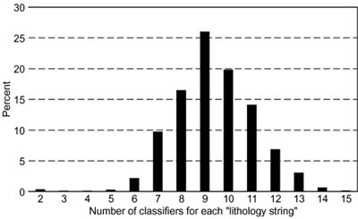
Figure 4. Histogram showing the range and frequency of the number of generic classifications implicit in each unique "lithology string." |
The frequencies with which composition can be applied to the test set of lithologies is illustrated in Figure 5. A composition could be inferred for more than 99%, and there is a reasonably good breakdown among the 14 categories represented. The dominance of the undivided "silicate" category (32.4% of lithologies, Figure 5) is likely due to the predominance of terrigenous sedimentary rocks in this particular map set. Subordinate composition is associated with only 17% of lithologies, but 12 categories are represented.
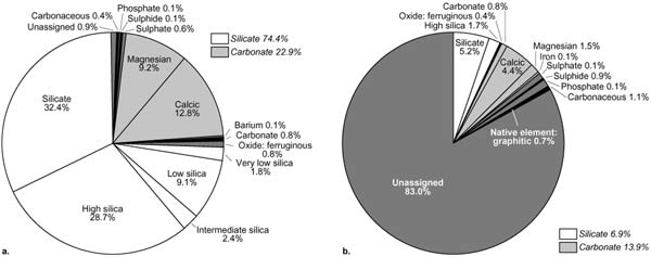
Figure 5. Breakdown of lithologies by their implicit composition. a. dominant composition. b. subordinate composition. |
The potential of genetic process as a discriminator is illustrated in Figure 6. Again, more than 99% of the test "lithology strings" could be assigned at least one genetic process, and about 17% a second process. Clastic (sedimentary) was the most common category, due to the particular map set used for this exercise, but, in total, 15 different values for genetic process were assigned in the first instance, and 11 for lithologies where a second process was implied.
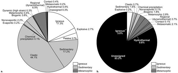
Figure 6. Breakdown of lithologies by their implicit genetic process. a. at least one process. b. second process. |
Environment of formation could be assigned to more than 98% of lithologies (Figure 7). For the 17% of "lithology strings" where a second genetic process was recognized, a corresponding environment of formation could be assigned in almost all instances. As in the case of composition and genetic process, the frequency of occurrence of the various processes reflects the nature of the geological terrane that forms the basis of this test map set.
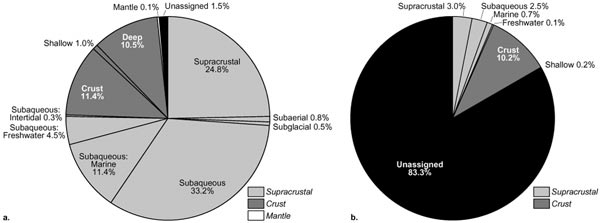
Figure 7. Breakdown of lithologies by their implicit environment of formation. a. first genetic process. b. second genetic process. |
Texture was classified under five separate schemes. Over 92% of lithologies could be assigned to either a granular or crystalline style of grain intergrowth, with a somewhat even split between the two categories (Figure 8a). Grain-size variability (Figure 8b) could be classified for about half of the "lithology strings," and was evenly split between homogeneous and heterogeneous, with about 2% classified as gradational. Grain size for the matrix (or all particles for homogeneous rocks) could be classified for two-thirds of the "lithology strings" (Figure 8c), with roughly one-third each in size class 2 (0.05-0.2 mm) and size class 3 (>0.2 mm), and less than 3% assigned to size class 1 (<0.05 mm). Although 24% of the "lithology strings" imply that the rocks are heterogeneous in grain size (Figure 8b), for less than 8% could the size of the coarse clasts or crystals be classified (Figure 8d), and almost all of these fell into size class 3. Grain-size morphology (Figure 8e) could be classified for only about 13% of the "lithology strings," and the majority of these fell into the "rounded" category. Finally, the proportion of matrix or groundmass to coarse clasts or crystals (rocks with heterogeneous grain size only) could be assigned to less than 5% of "lithology strings" (Figure 8f).
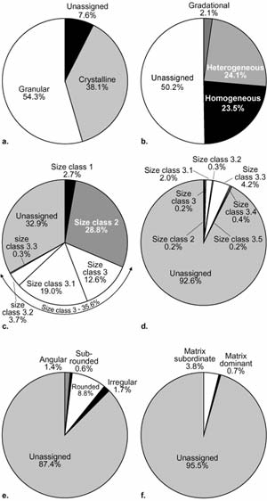
|
Figure 8. Breakdown of lithologies by their textural charactersistics. a. grain intergrowth. b. grain-size variability. c. grain size, matrix. d. grain size, clasts/megacrysts. e. grain morphology. f. matrix abundance. |
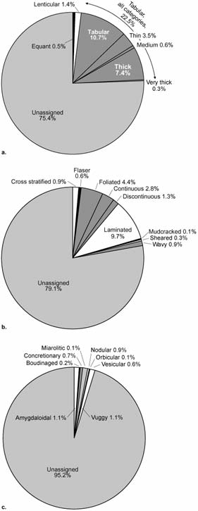
The last major category of indexes was based on physical form, both external habit and internal structure or fabric. External habit could be inferred for only about 25% of the "lithology strings" (Figure 9a), and nearly 23% of these were tabular, reflecting the predominance of stratified rocks in this map set. Internal structures were divided into two categories on the basis of their geometric dimensions: surfaces (2-D) and volumes (3-D). Because very few lithologies (less than 0.5%) were qualified by a linear (1-D) structure, this information has not been used. Almost 21% of "lithology strings" implied a planar fabric, either primary or secondary (Figure 9b), while less than 5% implied a 3-D internal structure (Figure 9c).
|
Figure 9. Breakdown of lithologies by their physical form. a. external habit. b. internal structure (fabric), surfaces. c. internal structure, volumes. |
The final property that influenced the power of these classification schemes to select map units on specific rock properties was how many are implicit in the "root" rock names themselves, so that queries such as "make a map of all the units that contain carbonate minerals" can be effectively and efficiently constructed. Table 11 contains the percentage of the 161 rock names from Table 10 that intrinsically contain information for each of the main classification schemes.
The results are not unexpected--composition, genetic process, and environment of formation, together with some textural properties, are implicit in most simple rock names. Similarly, a rough indication of the degree of consolidation can be inferred for most materials. Physical form was not very useful, and most of the textural classifications were useful for less than half of the simple rock names.
Table 11. Proportions of "root" rock names that implicitly
allow classification against 17 schemes developed to systematically
index lithological information from bedrock map units.
| Classification scheme |
Proportion of classified |
||
|---|---|---|---|
| Composition, dominant | 93% | ||
| Composition, subordinate | 2% | ||
| Genetic process, at least one | 97% | ||
| Genetic process, second | 19% | ||
| Environment of formation, first genetic process | 94% | ||
| Environment of formation, second genetic process | 19% | ||
| Texture, grain intergrowth | 86% | ||
| Texture, grain-size variability | 32% | ||
| Texture, grain size, matrix | 44% | ||
| Texture, grain size, clasts/megacrysts | <1% | ||
| Texture, grain morphology | 11% | ||
| Matrix proportion | 4% | ||
| Physical form, external habit | 0% | ||
| Physical form, internal surfaces | 7% | ||
| Physical form, internal volumes | 0% | ||
| Mechanical properties, induration | 99% | ||
| Mechanical properties, partings | 1% |
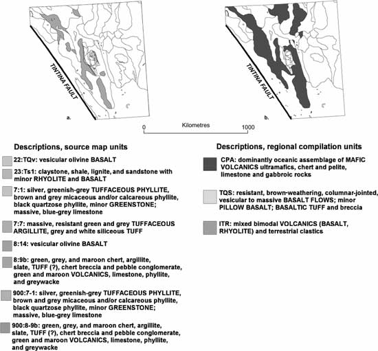
Figure 10. Results of a database query to select map units that contain volcanic rocks from the Yukon map set, shown for NTS sheet 105A only (see Figure 2). Left, source-map units; right, regional map units. The outlines of all units are shown, with those containing "volcanic" lithologies shaded, and their legend descriptions listed ("volcanic" lithologies capitalized). |
| lithology | proportion | ||
|---|---|---|---|
| sandstone, calcareous, marine | major | ||
| shale, concretionary, marine | minor |
and classified as in Table 12. The profile in Table 12 could be modified to relax or tighten the search constraints. For example, if the "Physical form, internal surfaces = laminated" and "Mechanical properties, partings = platy" criteria for the second lithology were dropped, then units with minor mudstone, siltstone, and other fine-grained marine, clastic, concretionary rocks would be selected. These lithological criteria can be combined with lithological proportions and the age range of the target map units.
Table 12. Generic lithological classification of a map unit described as "calcareous marine sandstone with minor concretionary
marine shale." The actual values for each category are stored in an attribute table as COA ID's from the conceptual classifications
in the COA table.
| Classification scheme | sandstone, calcareous, marine | shale, concretionary, marine | ||||
|---|---|---|---|---|---|---|
| Composition, dominant | silicate | silicate | ||||
|
Composition, subordinate |
carbonate>calcic |
|
||||
| Genetic process | sedimentary>clastic | sedimentary>clastic | ||||
|
Genetic process, second |
nul |
nul |
||||
|
Environment of formation, first genetic process |
supracrustal>subaqueous>marine | supracrustal>subaqueous>marine | ||||
|
Environment of formation, second genetic process |
nul |
nul |
||||
| Texture, grain intergrowth | granular | granular | ||||
| Texture, grain-size variability | homogeneous | homogeneous | ||||
| Texture, grain size, matrix | size class 3.1 | size class 2 | ||||
| Texture, grain size, clasts/megacrysts | nul | nul | ||||
|
Texture, grain morphology |
nul |
nul |
||||
|
Matrix proportion |
nul |
nul |
||||
| Physical form, external habit | nul | nul | ||||
| Physical form, internal surfaces | nul | laminated | ||||
|
Physical form, internal volumes |
nul |
concretionary |
||||
| Mechanical properties, induration | yes | yes | ||||
| Mechanical properties, partings | nul | platy |
These generic classification schemes for map units based on their lithological characteristics are preliminary, but we believe it is the type of classification scheme needed for a functional geological-map database. They are informed by geological principles, but do not purport to be anything more than categorical classifications. If we can make them truly generic we can unbundle the multidimensional nature of geological nomenclature. Such a classification scheme will greatly assist in making "derivative" maps, and perhaps in making geological map information less cryptic to the nonspecialist. Further, by keeping the number of "concepts" in the COA table to a reasonable size, the task of documenting the concepts (and translating the documentation into other languages) can be kept to a manageable size. Finally, by placing much of the detail (i.e., instances of concepts) in attribute tables, these can be managed locally, making the task of coordinating the "global concepts" more tractable. These generic classifications can also co-exist with more interpretative, thematic classifications at a regional map unit level such as that proposed by Struik and Quat (2002) for Tectonic Assemblages.
The project so far has addressed the map units of existing geological maps � the historical map information. For new maps, authors must be asked to place map units into predetermined higher levels, explicitly provide proportions of lithologies within map units, and complete the lithological indexing for map units. This last task will become much easier if geologists move toward the use of standard science language for rock names and qualifying information, as these standard terms would be already linked to generic keywords. Work on linear and point features from geological maps will be a task for the future.
Colman-Sadd, S.P., Ash, J.S., and Nolan, L.W., 1997, GEOLEGEND: a database system for managing geological map units in a geographic information system: Computers and Geosciences, v. 23, p. 715-724.
Colman-Sadd, S.P., and Crisby-Whittle, L.V.J., compilers, 2001, Partial bedrock geology data set for the Island of Newfoundland: Newfoundland Department of Mines and Energy, Geological Survey, Open File NFLD/2616 version 3.0.
Gabrielse, H., Monger, J.W.H., Wheeler, J.O., and Yorath, C.J., 1992, Part A. Morphological belts, tectonic assemblages, and terranes, Chapter 2 of Gabrielse, H., and Yorath, C.J., eds., Geology of the Canadian Cordilleran Orogen in Canada: Geological Survey of Canada, Geology of Canada No. 4, p. 15-28.
Gordey, S.P. and Makepeace, A.J., compilers, 1999, Yukon digital geology: Geological Survey of Canada Open File D3826 and Exploration and Geological Services Division, Yukon, Indian and Northern Affairs Canada, Open File 1999-1(D) CD-ROM.
Jackson, J.A., 1997, Glossary of geology (4th ed.). Falls Church, American Geological Institute, Virginia, 769 p.
Matti, J., 2002, Classification of sedimentary materials, with attributes for their description and interpretation: Unpublished report of the Sedimentary Subgroup, Science Language Technical Team (SLTT), North American Data Model Steering Committee, August 2002.
North American Commission on Stratigraphic Nomeclature, 1983, North American Stratigraphic Code: American Association of Petroleum Geologists Bulletin, v. 67, p. 841-875.
Okulitch, A.V., 2002, Geological time scale 2002: Geological Survey of Canada Open File 3040 (National Earth Science Series--Geological Atlas) REVISION.
Richard, S.M., 2002, Classification of metamorphic rocks and other composite-genesis rock types, including hydrothermally altered, impact-metamorphic, mylonitic, and cataclastic rocks: Unpublished draft report of the Subgroup on Metamorphic Rocks, Science Language Technical Team (SLTT), North American Data Model Steering Committee, May 13, 2002.
Struik, L.C., and Quat, M.B., 2002, Hierarchical classification of tectonic assemblages for use with thematic computer-based query systems: a preliminary scheme: Geological Survey of Canada Current Research No. 2002-E18, 2002; 5 p.
Struik, L.C., Quat, M.B., Davenport, P.H., and Okulitch, A.V., 2002, Multi-hierarchical rock classification for use with thematic computer-based query systems: Geological Survey of Canada Current Research No. 2002-D10, 9 p.
Weisenfluh, G.A., 2001, Map unit descriptions and the North American Data Model, in Soller, D.R.,, ed., Digital Mapping Techniques '01--Workshop Proceedings: U.S. Geological Survey Open-File Report 01-223, p. 79-86;
Wheeler, J.O., Brookfield, A.J., Gabrielse, H., Monger, J.W.H., Tipper, H.W., and Woodsworth, G.J., compilers, 1991, Terrane map of the Canadian Cordillera, Geological Map of Canada: Geological Survey of Canada Map 1713A, scale 1:2,000,000.
Wheeler, J.O., Hoffman, P.F., Card, K.D., Davidson, A., Sanford, B.V., Okulitch, A.V., and Roest, W.R., compilers, 1997, Geological Map of Canada: Geological Survey of Canada Map D1860A, CD-ROM.
Wheeler, J.O., and McFeely, P., compilers, 1991, Tectonic Assemblage map of the Canadian Cordillera and adjacent parts of the United States of America, Geological Map of Canada: Geological Survey of Canada Map 1712A, scale 1:2,000,000.
RETURN TO Contents
National Cooperative Geologic
Mapping Program | Geologic Division |
Open-File Reports
U.S. Department of the Interior, U.S. Geological Survey
URL: https://pubsdata.usgs.gov/pubs/of/2002/of02-370/davenport.html
Maintained by David R. Soller
Last modified: 19:15:34 Wed 07 Dec 2016
Privacy statement | General disclaimer | Accessibility