MinGIS
15540 Minnetonka Circle
Reno, NV 89521
Telephone: (775) 853-3933
Fax: (775) 853-3973
e-mail: g.edmondo@worldnet.att.net
The focus of the research was to minimize the size and weight of computer systems. Systems identified consist of a wearable PC or handheld computer (PDA) and lightweight GPS systems that can be used for a variety of tasks. These systems would incorporate ArcPad, a scalable, customizable field-based data-capture software package. ArcPad provides the user with the functionality needed to build a geologic map in the field and with data-capture methods to allow mapping to fit the needs of the project. Field testing has shown the hardware-software systems to be effective field-based solutions for the Earth sciences.
Digital capture of geologic data in the field requires very complex graphical and database-management models. Early attempts at digital data capture were designed to input field data straight into database tables (Brodaric and Fyon, 1989) or into data collectors from early GPS units and other types of survey equipment (Walsh and others, 1999). Both of these methods required extensive processing in the office to produce a spatial map, negating any time savings gained by digital field capture. A mapping system was needed that captured and then displayed geologic features in real time.
Recent advances in computer technology and geographic information system (GIS) software have allowed for more complex data models to be captured digitally on personal computers (Kramer, 2000). Due to these innovations, Placer Dome Exploration began to research the practicality of digital field mapping and what is needed and currently available to accomplish the task. Placer Dome hired me as a consultant to review their efforts and make changes or recommendations as needed. This paper is a brief reporting of those results and changes.
Portability is not the only factor. A geologist needs to be unencumbered during his work, so cumbersome systems (e.g., those with a lot of external cabling or large attachments) had to be removed from consideration. Additional criteria included internal vs. external batteries, battery type, and screen readability. Screen visibility is an important issue and is most apparent in bright-light conditions. However, depending on screen technology, visibility can also be an issue in low-light conditions as well (e.g., nonbacklit transflective screens). The best screen technology is a backlit transflective screen used in several computers, such as the Hewlett Packard iPAQ Pocket PC, and this technology is being applied by more and more hardware manufacturers on their units. Ruggedness also can be important, depending on the environment. Harsh environments (tropics, jungles, cold weather) may require the use of rugged machines; less harsh environments (deserts, subtropics, Mediterranean climates) allow the use of moderate to nonrugged equipment. Table 1 summarizes some of the critical factors in evaluating hardware.
Table 1. Factors used to aid in hardware selection for digital field-mapping systems.
| Requirement | Determining Factors | ||
|---|---|---|---|
| Size, morphology | Proximity to infrastructure, vehicles; carrying capability | ||
| Weight | Physical carrying restrictions | ||
| Battery type/life | Operating time frame, cost, added weight | ||
| Processor and data storage | Amount and type of background data to be used, and amount of data to be captured | ||
| GPS accuracy | Scale of mapping project | ||
| Connectivity | Number of peripheral devices to be used (GPS, laser rangefinder, etc.) | ||
| Display | Readability in low-light and bright-light conditions, available screen-display size | ||
| Ruggedness | Environment (tropics/desert) | ||
| Cost | Budget |
Selecting a computer-GPS system for field work is as much a matter of personal preference as it is capability. With the evolution in computer technology, it is likely the number of available choices will increase every year, with units becoming smaller, lighter, and more powerful. Acceptable computers can be categorized into two basic processor classes. These are PC computers with x86-based processors running Microsoft Windows 95, 98, or 2000 as an operating system, and devices using various forms of RISC-based processors (PDA's, Web tablets) running Windows CE or Pocket PC operating systems. Three workable configurations exist for the field geologist. These are tablet PC's and PDA's, wearable PC's, and handheld (PDA) devices. PC-based systems provide their main benefit where large amounts of data will be generated and the need for storage and processing power are critical. It can be difficult to carry tablet-style PC or RISC-based units in the field, particularly when working outcrops. Also, battery life is typically poor on PC-based units. In contrast, handheld PDA devices do not yet have the processing power or storage capability to handle the very large data sets or large data-capture requirements in detailed mapping and project work. Nor do handheld PDA devices have sufficient screen area to manage interpretive mapping over a large physical region. RISC-based tablet and PDA devices provide their main benefit where data acquisition needs are minimal, such as small-scale mapping or sampling work in which point data and simplified maps are generated. Handheld PDA devices can be easily carried and used in the field. These smaller machines tend to have longer battery lives and are more cost effective. With the advent of secure digital storage cards, PDA devices can now hold a large amount of information. Recent hardware innovations have brought several lightweight, wearable PC-computer systems (such as the Xybernaut MA V) to the forefront of mapping technology. These smaller PC-based units are a good mix between PC tablets and handheld PDA units and offer the best combination of data capture and storage ability versus the weight, carrying ability, and battery life of the computer.
GPS units fall into three broad categories based on DGPS (differential correction) accuracy: (1) survey-grade receivers with accuracies in the centimeter to millimeter range, (2) mapping-grade receivers that are accurate to the 1-m range, and (3) recreational-grade receivers that are accurate from 5 to 15 m. These accuracies, even for recreational-grade receivers, are typically more accurate than locations plotted by hand on a topographic map at scales of 1:12,000 and smaller. Like computers, GPS receivers also come in a variety of physical configurations. Most survey and mapping grade GPS receivers are configured either as a backpack system with receiver separate from antenna, or as integrated receiver-antenna domes (Trimble Pathfinder Power and Pro XR series). Recreational grade units are configured as either handheld units (Garmin, Magellan, Trimble), low-power compact flash-card units, or as compact integrated domes.
The variety in computing power and morphology and GPS accuracy and morphology provide for a multitude of combinations available for use in field work. System design, however, should be tailored to the needs and requirements for the mapping task at hand. Computer selection should follow the guidelines as outlined in Table 1, with consideration for the environment to work in, amount and type of data sets to use, and area to be covered. GPS units need to be chosen with accuracy and mapping scale as the overall guiding factors. Except for certain tasks, survey-grade receivers need not be used. Mapping-grade receivers offer the best flexibility in terms of accuracy for detail work and weight for more regional projects. Recreational-grade receivers, without a differential correction, should only be used for mapping work at scales less than 1:6,000. Table 2 summarizes various scenarios, requirements, and recommendations on the type of system to use.
Table 2. Scenarios, requirements, and recommendations for field digital data-capture systems.
| Requirements | Scenario | GPS | Computer | ||||||
|---|---|---|---|---|---|---|---|---|---|
|
Accuracy |
|||||||||
| Centimeter | Claim staking, land surveying | Survey grade | Any (dependent on amount of base data and data capture) | ||||||
| Submeter/meter | Detail mapping at scales of 1:6,000 or greater, detail sampling | Mapping grade | Wearable PC, handheld PDA | ||||||
| >1 meter | Sampling, reconnaissance | Mapping/recreation | Handheld PDA, Tablet PDA | ||||||
|
Data sets |
|||||||||
| Large data set | Advanced project, development, mine site | Mapping/survey grade | Tablet/wearable PC | ||||||
| Moderate data set | Advanced project, project work | Mapping grade | Tablet/wearable PC or PDA | ||||||
| Minimal data set | Reconnaissance mapping, sampling | Recreation/mapping grade | PDA | ||||||
|
Battery life |
|||||||||
| Long life | Inaccessible AC power/ long distance from vehicle or office | Recreation/mapping grade | PDA/wearable PC | ||||||
| Moderate life | Inaccessible power, long stay in field | Recreation/mapping grade | Wearable PC/PDA | ||||||
| Short duration | Nearby power supply/ vehicle | Survey/mapping grade | Tablet PC | ||||||
|
Weight of system |
|||||||||
| Heavy (weight not issue) | Infrastructure/mine site | Survey/mapping grade, backpack style, integrated | Tablet PC | ||||||
| Moderate (weight of moderate concern) | Mine site to detailed project work (with no infrastructure) | Mapping grade, either backpack or integrated | Wearable PC | ||||||
| Light (weight of high concern) | Reconnaissance, early stage projects, sampling | Recreation grade/mapping grade | PDA/wearable PC | ||||||
CAD tools are necessary for the building of the graphical (map) part of the data set. Tools need to be flexible enough for a variety of different input methods, including GPS input, laser rangefinder input, or hand digitizing, yet be flexible enough such that a variety of methods can be used to capture a single piece of data (such as a fault or contact). CAD tools should also be easy to understand and use, so the field geologist spends less time thinking about what to use, and more time thinking about the geology. The ultimate desire is to provide the geologist the ability to map features as he would on pen and paper.
Data-management (GIS) tools are necessary for the input and storage of field observation notes as well as for project management and setup. Part of the efficiency in digital field mapping is the speed of data entry. Mapping software should support the use of form-based data entry to minimize the amount of typing needed to enter data. Form-based data entry also provides data validation and consistency in values used when data are input by more than one person. GIS tools also are helpful for integrating mapping skills with other data sets (layers) such as geophysics and geochemistry. Field observations and integration of other data sets form the basis for final map interpretation. The overall quality of that interpretation is dependent on the type, quantity, quality, and accuracy of the data being added into the database.
Geologic mapping software also needs to interface with the office software used to set up a mapping project and the software used to produce the final map product. Efficiencies gained in the field are lost if the geologist has to spend time formatting data to interface with the setup and production software. With the current trend of producing maps for Web-based use, integration with a data management and storage system also is necessary. The ideal is a seamless integration of data sets between all three aspects of map production.
Very few mapping packages are available that meet the needs of geologic mapping. Three packages that do meet most of these criteria are ArcPad 6.0 (ESRI), Penmap (Strata Software), and Geolink (Michael Baker Jr. Corp.). ArcPad was selected by Placer Dome because it met most of the user requirements and was a very cost effective solution.
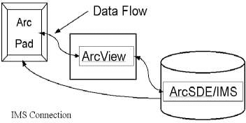
ArcPad integrates near seamlessly with ArcView and ArcGIS as a front-end data-capture solution. Although not perfect (no software package is), ArcPad and the ArcGIS suite of software provide the field user with the flexibility needed to manage all aspects of a field-mapping project, from setup to final map production, and data storage. This integration provides for better data management, better project management, and more efficient data acquisition and manipulation (Figure 1). Geologically, using ArcView and ArcGIS to establish a mapping project in ArcPad provides significant benefits, including the ability to develop and use custom symbols, establish symbol rotation, and construct legends for data values. This capability allows for simple mid-project changes in symbology and/or data values, additions or deletions of data layers, and complex editing tasks.
|
Figure 1. Diagram showing the relationship of ArcPad to the ArcGIS suite of software in a scalable data-management solution. |
In addition to ArcPad's integration with ArcView and the ArcGIS suite of software, ArcPad has additional strengths. ArcPad is fully customizable. Using ArcPad Studio, standard form files, standard layers, and customizable pick lists can be built into a template (Figure 2). The template structure allows for automation of the ArcPad command process and provides for more efficient data capture. Data can be captured in either two or three dimensions, and spatial and attribute value editing of previously existing data is possible. ArcPad supports PC (Windows 95, 98, 2000) and PDA (Windows CE, Pocket PC) operating systems, allowing for the same customization to be used on different field-unit platforms. This is beneficial when several people will work on the same project, but have different tasks to accomplish, or in projects that grow from small, regional-scale programs to advanced mapping projects.
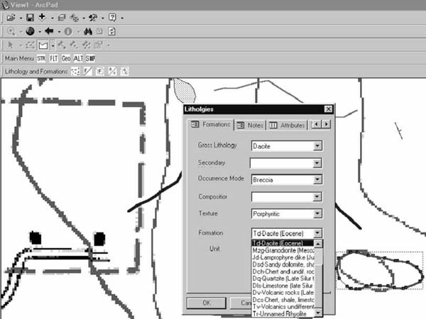
Figure 2. Features in a customized ArcPad environment. |
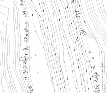
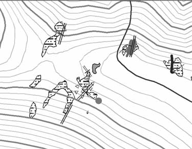
ArcPad's capabilities for geologic mapping are best suited for fact-based observational mapping. It has been field tested on several mapping and sampling projects, including mine-pit mapping (Figure 3) and surface mapping (Figure 4). These two examples were built entirely within the ArcPad-ArcView-ArcGIS environment using a standard set of template files in a customized menu structure. They show some capabilities of ArcPad. Although commonly used in an observational (outcrop or fact-based) mapping environment by the mining industry, ArcPad is not limited to that function. Other uses for ArcPad include standard geologic mapping (interpretive), detail mapping at scales of 1:6,000 or less, geophysical surveys, geochemical surveys, environmental studies, and structural studies. Because of the customization environment, ArcPad can be used for any aspect of mapping required by the Earth sciences.
|
Figure 3. Example of a mine-pit map, created using a Xybernaut wearable PC, Pathfinder Power GPS, and ArcPad (courtesy of Placer Dome). |
|
Figure 4. An example of surface observational mapping, created using a Compaq iPAQ and compact flash GPS with ArcPad (courtesy of Cortez Gold Mines). |
GIS data-acquisition software is currently undergoing a technological evolution, with many new software packages coming to the market. This is in direct response to availability of hardware and the need for efficient data collection and upkeep for field-based industries. In the future, these new software developments, and the trend toward smaller, more powerful computer and GPS devices will continue to provide even greater enhancements to digital geologic field mapping.
Kramer, J.H., 2000, Digital mapping systems for field data, in Soller, D.R., ed., Digital Mapping Techniques '00 -- Workshop Proceedings: U.S. Geological Survey Open-File Report 00-325, p. 13-19, https://pubs.usgs.gov/openfile/of00-325/kramer.html.
Schetselaar, E., 1995, Computerized field-data capture and GIS analysis for generation of cross sections in 3-D perspective views: Computers and Geosciences, v. 21, p. 687-701.
Walsh, G.J., Reddy, J.E., and Armstrong, T.R., 1999, Geologic mapping and collection of geologic structure data with a GPS receiver and a personal digital assistance (PDA) computer, in Soller, D.R., ed., Digital Mapping Techniques '99 -- Workshop Proceedings: U.S. Geological Survey Open-File Report 99-386, p. 127-131, https://pubs.usgs.gov/of/of99-386/walsh.html.