Department of Geography
University of California Santa Barbara
Santa Barbara, CA 93106
Telephone: (805) 893-3663
Fax: (805) 893-8617
e-mail: jordan@geog.ucsb.edu
In this paper, we describe the development of a geologically sophisticated gazetteer service, the Tahoe Regional Gazetteer (TARGA), which interrelates feature names with geologic maps. In conjunction, TARGA has built an inventory of 69 data sets, including 16 geologic maps, for the LTR, accumulated into a standardized repository. All three of TARGA's component subsystems--inventory, repository, and gazetteer--are Web accessible and Web mapped, providing convenient answers to such questions as: What geological maps exist for cultural and/or physical feature(s) "X"? In addition to its online capabilities, TARGA has accumulated a valuable database for future research on the geology of the LTR, and for geologic-map data-management systems in general.
|
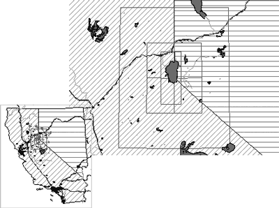
Figure 1. The Lake Tahoe region: 2° box surrounding 1° TARGA boundary, with TEGIS inset. |
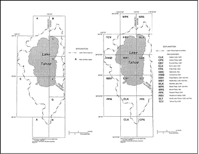
A fundamental component of TEGIS, given Lake Tahoe's setting in a large, deep, and still tectonically active graben, is regional geology. Numerous geologic maps for the region exist (Cartier and others, 1994; Hess and Johnson, 1997; Bedford and others, 2002). These maps have been produced by different mappers at different times, in a variety of scales (1:24K, 1:62.5K, 1:250K, 1:500K [Nevada], and 1:750K [California]), projections (UTM10, UTM11, State Plane, Albers), and datums (NAD27, NAD83), as shown in Figure 2. The larger scale (<1:100K) and the smaller scale (≥1:250K) maps independently tile the region, thus overlapping each other and providing a welter of technical GIS challenges, in addition to scientific ones. A variety of USGS topographic base maps at 1:24K, 1:100K, and 1:250K also exist for the region.
|
Figure 2. TEGIS geologic mapping by USGS and TRPA; 10 geologic maps cover 16 1:24K topographic quadrangles (from Cartier and others, 1994). |
Humans have occupied the environs of Lake Tahoe for at least 8,000 years (Forbes, 1982; Moratto, 1984), and in this period a large number of its cultural and physical features have been named (and renamed) in several languages. These names form the traditional basis for place identification, navigation, and wayfinding in the region. Some names are essentially point features (mountain peaks, springs, trail heads, forks, etc.), others are largely linear (creeks, roads, trails, etc.), and the majority are clearly areal (lakes and ponds, settlements, mine sites, wilderness areas, etc.). Most of the modern names appear on topographic maps, which the USGS Geographic Names Information System (GNIS, http://geonames.usgs.gov/) excerpts to point locations (often feature centroids, but sometimes simply georeferenced map-label positions). Other sources of georeferenced names include GIS/map data from commercial providers, the various Federal land management agencies, the states of California and Nevada (particularly their state geological surveys), local municipalities, historical documents, and, ultimately, anecdotal/common usage. Obviously, people can find their way to and among named features, whether or not these have been mapped, so undoubtedly more names exist than are documented in GNIS.
In this article, we describe a fusion of geological and topographic maps with a digital gazetteer 2 (Hill, 2001) for the LTR: the Tahoe Regional Gazetteer (TARGA). In the first instance, TARGA's purpose is largely geological, designed to answer such questions as:
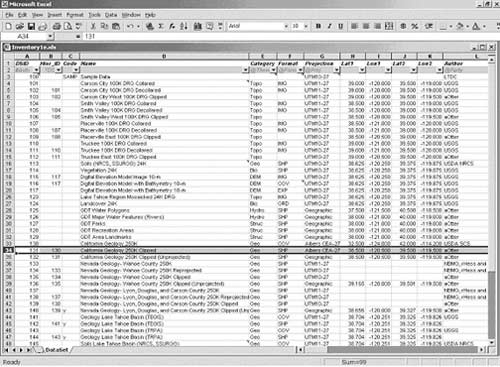
Figure 3a. TARGA Inventory workbook. |
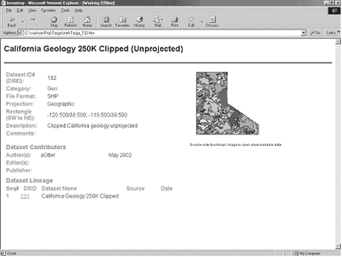
Figure 3b. TARGA Inventory Web page for one map product. |
Specifically, the query process is: (1) the selected feature names/types are matched within the gazetteer, which returns their locations and/or MBR's; (2) the inventory is searched to determine data sets that contain the places (by point-in-rectangle and/or rectangle-on-rectangle overlay calculation, based on the data sets' MBR's); and (3) the qualifying data sets from the repository are shown in map view. In addition, a simple list of the qualifying data sets is made available outside the GIS. To increase the specificity of the system, and to reduce false retrievals, feature matches may be limited within a region of interest, indicated either by MBR (directly) or by name (indirectly, again using the gazetteer). For convenience, the system is Web accessible, which in turn mandates that the query interface be kept simple. A sample query/retrieval dialog from TARGA is shown in Figure 4.
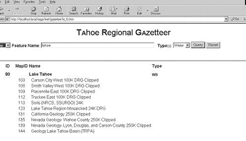
Figure 4. TARGA Gazetteer interface, showing maps on which Lake Tahoe appears. |
Access to descriptive data about the data sets retrieved--metadata--also is important. Basic metadata for each of the datasets is provided by supporting Web pages, one per data set, automatically generated by VBA scripts from the inventory subsystem, as previously mentioned. A sample page is shown in Figure 3b. These metadata pages are explicitly linked in the list of retrieved data sets; they are also implicitly linked to the Web-mapping display (accessible by right-click). The entire collection of metadata pages is centrally available via the inventory subsystem.
TARGA is hosted on an MS Windows 2000 Server system, running MS Internet Information Server 5. Accordingly, the query interface is implemented in .asp scripts.
Basic GIS/Web-mapping support is provided by Environmental Systems Research Institute (ESRI) ArcView IMS software, running on the same system.
Future work with TARGA will be to migrate its gazetteer database from Excel to Access, and also to modernize its Web mapping, using ESRI ArcIMS v4 in place of ArcView IMS. In conjunction with these changes, more sophisticated spatial operations, involving general polygon-on-polygon operations, as well as the present simple MBR tests, will be supported. Also, nongeographic reprojection of raster data sets together with vector data sets will be possible.
Cartier, K.D., Peltz, L.A., and Smith, J.L., 1994, Development and documentation of spatial data bases for the Lake Tahoe Basin, California and Nevada: U.S. Geological Survey Water Resources Investigation Report 93-4182, 65 p.
Clinton, W.J., 1997, Federal actions in the Lake Tahoe Region: Office of the President, Executive Order #13057, dated July 26, 1997; http://www.usda.gov/news/tahoe/ninteen.htm.
Forbes, J.D., 1982, Native Americans of California and Nevada: Happy Valley, California, Naturegraph Publishers, 240 p.
Hess, R.H., and Johnson, G.L., 1997, County digital geologic mapping project: Nevada Bureau of Mines and Geology Open File Report 97-1, CD-ROM.
Hill, L.L., 2000, Core elements of digital gazetteers: placenames, categories, and footprints, in Borbinha, J., and Baker, T., eds., Research and advanced technology for digital libraries: Proceedings of the 4th European Conference, ECDL 2000 Lisbon, Portugal, September 18-20, 2000, Springer: Berlin, p. 280-290; http://www.alexandria.ucsb.edu/~lhill/paper_drafts/ECDL2000_paperdraft7.pdf. Moratto, M.J., 1984, California archaeology. Orlando, Florida, Academic Press, 757 p.
Appendix A. TARGA Repository Contents
|
DSID #Auto |
Hier_ID *DSID |
Name |
Format @Form |
Projection @Proj |
SourceScale | ||||||||||||
|---|---|---|---|---|---|---|---|---|---|---|---|---|---|---|---|---|---|
| 100 | Sample Data | UTM10-27 | |||||||||||||||
| 101 | Carson City Topo Collared | IMG | UTM11-27 | 1:100,000 | |||||||||||||
| 102 | 101 | Carson CityTopo Decollared | IMG | UTM11-27 | 1:100,000 | ||||||||||||
| 103 | 102 | Carson City West Topo Clipped | GRD | Geographic | 1:100,000 | ||||||||||||
| 104 | Smith Valley Topo Collared | IMG | UTM11-27 | 1:100,000 | |||||||||||||
| 105 | 104 | Smith Valley Topo Decollared | IMG | UTM11-27 | 1:100,000 | ||||||||||||
| 106 | 105 | Smith Valley West Topo Clipped | GRD | Geographic | 1:100,000 | ||||||||||||
| 107 | Placerville Topo Collared | IMG | UTM10-27 | 1:100,000 | |||||||||||||
| 108 | 107 | Placerville Topo Decollared | IMG | UTM10-27 | 1:100,000 | ||||||||||||
| 109 | 108 | Placerville East Topo Clipped | GRD | Geographic | 1:100,000 | ||||||||||||
| 110 | Truckee Topo Collared | IMG | UTM10-27 | 1:100,000 | |||||||||||||
| 111 | 110 | Truckee Topo Decollared | IMG | UTM10-27 | 1:100,000 | ||||||||||||
| 112 | 111 | Truckee East Topo Clipped | GRD | Geographic | 1:100,000 | ||||||||||||
| 113 | Soils (LTDC) | SHP | UTM10-27 | 1:24,000 | |||||||||||||
| 114 | Vegetation | SHP | UTM10-27 | 1:24,000 | |||||||||||||
| 115 | 117 | DEM Image 10-m | IMG | UTM10-27 | |||||||||||||
| 116 | 117 | DEM with Bathymetry 10-m | COV | UTM10-27 | |||||||||||||
| 117 | DEM with Bathymetry 10-m | EXP | UTM10-27 | ||||||||||||||
| 118 | Buildings | SHP | UTM10-27 | 1:24,000 | |||||||||||||
| 119 | Docks | SHP | UTM10-27 | 1:24,000 | |||||||||||||
| 120 | Hydrology | SHP | UTM10-27 | 1:24,000 | |||||||||||||
| 121 | Hypsography | SHP | UTM10-27 | 1:24,000 | |||||||||||||
| 122 | Roads | SHP | UTM10-27 | 1:24,000 | |||||||||||||
| 123 | Lake Tahoe (LTDC) Topo | IMG | UTM10-27 | 1:24,000 | |||||||||||||
| 124 | Landcover | GRD | UTM10-27 | 1:24,000 | |||||||||||||
| 125 | GDT Water Polygons | SHP | Geographic | ||||||||||||||
| 126 | GDT Major Water Features (Rivers) | SHP | Geographic | ||||||||||||||
| 127 | GDT Parks | SHP | Geographic | ||||||||||||||
| 128 | GDT Recreation Areas | SHP | Geographic | ||||||||||||||
| 129 | GDT Area Landmarks | SHP | Geographic | ||||||||||||||
| 130 | CA Geology | COV | Albers CEA-27 | 1:250,000 | |||||||||||||
| 131 | 130 | CA Geology Clipped | SHP | Albers CEA-27 | 1:250,000 | ||||||||||||
| 132 | 131 | CA Geology Clipped | SHP | Geographic | 1:250,000 | ||||||||||||
| 133 | NV Geology- Wahoe | SHP | UTM11-27 | 1:250,000 | |||||||||||||
| 134 | 133 | NV Geology- Wahoe Reprojected | SHP | UTM10-27 | 1:250,000 | ||||||||||||
| 135 | 134 | NV Geology- Wahoe Clipped | SHP | UTM10-27 | 1:250,000 | ||||||||||||
| 136 | 135 | NV Geology- Wahoe Clipped | SHP | Geographic | 1:250,000 | ||||||||||||
| 137 | NV Geology- Lyon,Douglas,Carson | SHP | UTM11-27 | 1:250,000 | |||||||||||||
| 138 | 137 | NV Geology- Lyon, Douglas, Carson Reprojected | SHP | UTM10-27 | 1:250,000 | ||||||||||||
| 139 | 138 | NV Geology- Lyon,Douglas,Carson Clipped | SHP | UTM10-27 | 1:250,000 | ||||||||||||
| 140 | 139 | NV Geology- Lyon, Douglas, Carson Clipped | SHP | Geographic | 1:250,000 | ||||||||||||
| 141 | Geology Lake Tahoe Basin (TEGIS) | COV | UTM11-27 |
1:24,000 1:62,500 1:125,000 |
|||||||||||||
| 142 | 141 | Geology Lake Tahoe Basin (TEGIS) | SHP | UTM11-27 |
1:24,000 1:62,500 1:125,000 |
||||||||||||
| 143 | Geology Lake Tahoe Basin (TRPA) | COV | UTM11-27 |
1:24,000 1:62,500 1:125,000 |
|||||||||||||
| 144 | 143 | Geology Lake Tahoe Basin (TRPA) | SHP | UTM11-27 |
1:24,000 1:62,500 1:125,000 |
||||||||||||
| 145 | Soils (TRPA) | COV | UTM11-27 | 1:24,000 | |||||||||||||
| 147 | LTDC Mapbounds | SHP | Geographic | n/a | |||||||||||||
| 148 | TRPA, TEGIS Mapbounds | SHP | Geographic | n/a | |||||||||||||
| 149 | 1 Degree Mapbounds | Geographic | SHP | n/a | |||||||||||||
| 150 | 2 Degree Mapbounds | SHP | Geographic | n/a | |||||||||||||
| 151 | 3 Degree Mapbounds | SHP | Geographic | n/a | |||||||||||||
| 152 | Hydrologic Units Map Great Basin | COV | Albers CEA-1866 | 1:250,000 | |||||||||||||
| 153 | 152 | Hydrologic Units Map Great Basin Clipped | SHP | Albers CEA-1866 | 1:250,000 | ||||||||||||
| 154 | 153 | Hydrologic Units Map Great Basin Clipped w/ 5 Mapbounds | SHP | Geographic | 1:250,000 | ||||||||||||
| 155 | Hydrologic Units Map CA 250K | COV | Albers CEA-1866 | 1:250,000 | |||||||||||||
| 156 | 155 | Hydrologic Units Map CA Clipped | SHP | Albers CEA-1866 | 1:250,000 | ||||||||||||
| 157 | 156 | Hydrologic Units Map CA Clipped w/ 9 Mapbounds | SHP | Geographic | 1:250,000 | ||||||||||||
| 158 | Streams- US | COV | Albers CEA-1866 | 1:2,000,000 | |||||||||||||
| 159 | 158 | Streams- CA,NV Clipped | SHP | Albers CEA-1866 | 1:2,000,000 | ||||||||||||
| 160 | 101 | Carson City Topo Collared | GRD | UTM11-27 | 1:100,000 | ||||||||||||
| 161 | 101 | Carson City Topo Collared Unprojected | GRD | Geographic | 1:100,000 | ||||||||||||
| 162 | 104 | Smith Valley Topo Collared | GRD | UTM11-27 | 1:100,000 | ||||||||||||
| 163 | 104 | Smith Valley Topo Collared Unprojected | GRD | Geographic | 1:100,000 | ||||||||||||
| 164 | 107 | Placerville Topo Collared | GRD | UTM10-27 | 1:100,000 | ||||||||||||
| 165 | 107 | Placerville Topo Collared Unprojected | GRD | Geographic | 1:100,000 | ||||||||||||
| 166 | 110 | Truckee Topo Collared | GRD | UTM10-27 | 1:100,000 | ||||||||||||
| 167 | 110 | Truckee Topo Collared Unprojected | GRD | Geographic | 1:100,000 | ||||||||||||
| 168 | 103; 106; 109,112 | Tahoe Region Topo | GRD | Geographic | 1:100,000 | ||||||||||||
| 169 | 168 | Tahoe Region Topo | IMG | Geographic | 1:100,000 |
NOTE: Only selected attributes are shown; the full list of attributes for each data set is:
UniqueID #, Hierarchical/Parent ID#, Source Scale, File Size, Code (Web availability), Name, Category, Format, Projection,
Mapbound extent (Lat1, Lon1, Lat2, Lon2), Author, Author Date, Editor, Editor Date, Publisher, Publisher Date, Description,
Comments, Thumbnail Image, and Filepath.
Appedix B. TARGA Gazetteer Database Schema
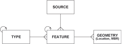
SOURCE (ID, Name, . . .) TYPE (ID, Parent-ID, Code, Name, . . . ) FEATURE (ID, Parent-ID, SOURCE-ID, TYPE-ID, Name, . . .) GEOMETRY (FEATURE-ID, Location-Lat, Location-Long, MBR-Lat1, MBR-Lon1, MBR-Lon2, . . .) Notes:
|