1Montana Bureau of Mines and Geology
Montana Tech of the University of Montana
Butte, MT 59701-8997
Telephone: (406) 782-8633
Fax: (406) 496-4451
e-mail: pkennelly@mtech.edu
2Utah Geological Survey
P.O. Box 146100
Salt Lake City, UT 84114-6100
Telephone: (801) 537-3355
Fax: (801) 537-3400
e-mail: grantwillis@utah.gov
The U.S. President's Management Council recently identified 23 federal government initiatives that relate to Electronic Government (E-Gov). Of these, four have an important GIS component: Homeland Security, The National Map, Geospatial One-Stop, and Implementation Team (I-Team). In this paper, we briefly summarize the first three initiatives, but focus on the I-Team Initiative, which has the most application to the science of geology.
One current pilot project of The National Map Initiative has a geologic component. The Missouri Pilot Project is working in cooperation with the National Cooperative Geologic Mapping Program to support multi-hazard risk assessment, mitigation, and emergency planning. The study area comprises four USGS 7.5-minute quadrangles (scale 1:24,000) with flooding and seismic risk. Geologic data will be integrated with updated National Map Initiative base themes. For an example, see USGS Web site
The I-Team members first develop a list of key "framework" layers for their database and identify the most likely sources for each layer. The team then develops a plan to assemble and maintain the database, assigns or recommends duties to team members, and encourages the formation of cooperatives to streamline data assembly, coordinate efforts, and increase efficiency.
Generally, I-Teams begin with the seven framework layers identified by the Federal Geographic Data Committee: cadastral (public land surveys and ownership), elevation, geodetic control, government units, hydrography, digital orthoimagery, and transportation. I-Teams then typically identify additional key framework layers. For example, because the Montana Geographic Information Council also recognizes geology, hydrologic units, soil, and land use/land cover as priority themes, these themes were included in Montana's I-Team Initiative. In the Utah Framework Implementation Plan, demographics, wetlands, geology, wildlife habitat, climate, ground cover, land use, soils, telecommunications infrastructure, critical facilities and infrastructure, and environmental hazards were identified as additional key themes.
Prior to UGS involvement, the Utah I-Team viewed the geologic layer as simply consisting of one seamless data layer that they referred to as "surface geology" and assumed that it would be at a scale of 1:24,000. As the UGS staff became more involved, they pointed out that at current rates of mapping, it will require 100 years to complete 1:24,000 scale geologic map coverage of the state. The UGS instead recommended a more complex, but more practical system of three layers of geologic map data: 1:500,000 scale, which was already available in GIS format; 1:100,000 scale, which is the primary focus of their STATEMAP geologic mapping program; and 1:24,000-scale mapping in specific areas with high-priority needs (primarily centered around rapid urban growth). In addition, they recommended that geologic hazards and economic geology be added as parts of the core geology layer. Thus, the I-Team eventually decided to divide the geology layer into three parts (geologic maps, geologic hazards, and economic geology), with seven sublayers (Table 2). This plan did not include every type of geologic data, but instead struck a balance between the overly simplistic map first conceived and the endless "wish list" that a group of geologists could conjure up.
Table 2. The Utah I-Team Geology Framework Layer developed in early 2001.
We thank the members and staff of the National Cooperative Geologic Mapping Program who have advanced the development of geologic databases at local, state, and national levels. We also thank the many people who developed and worked behind the scenes to make the 2002 Digital Mapping Techniques Workshop in Salt Lake City, where this paper was first presented, a success. Finally, we thank our reviewers, Edmond Deal at the Montana Bureau of Mines and Geology, and Kent Brown, Robert Biek, and William Case at the Utah Geological Survey.
Geospatial One-Stop Initiative
The Geospatial One-Stop Initiative goals are to
provide an interactive index to geospatial data holdings at the federal and nonfederal levels,
I-Team Initiative
The Implementation-Team (I-Team) Initiative, the focus of this paper, is envisioned as a "bottom-up" approach. Its goal is to implement the construction of key framework layers through interagency cooperation and partnerships. These layers will compose the National Spatial Data Infrastructure, and the contributing agencies will work in cooperation with the Federal Geographic Data Committee and the Federal Office of Management and Budget (OMB). I-Teams will be separate from, but work in cooperation with, technology advisory groups and financing solution teams (Figure 1).

Figure 1. Schematic of I-Team implementation strategy (from http://www.fgdc.gov/I-Team/).
Interaction Among These Initiatives
These four initiatives incorporate GIS into E-Gov with considerable overlap. For example, to create base layers for The National Map, the framework layers produced through I-Team activities will be needed. These layers in turn will affect standards, models, and distribution processes related to Geospatial One-Stop.
I-TEAMS
Team Makeup and Goals
Most I-Teams are constructed at the state level; however, they also can be constructed at a multistate level (for example, Rocky Mountain states); or around a major theme (for example, Colorado River users). The central concept of an I-Team is to assemble all GIS data producers, suppliers, and users who have an interest in the geographic area of concern. Team members commonly consist of representatives of state agencies (transportation, agriculture, public safety, governor's planning council, school trust land administrations, and geological surveys, among others); federal agencies (Forest Service, Park Service, Bureau of Land Management, military, and others); local governments (city and county units, water districts, law enforcement agencies, and others); academia (university geography, geology, and other departments; school districts; and others); and private interests (gas and electrical utilities, pipeline companies, communications companies, and others). There is probably an I-Team in your state. State geological surveys may need to actively seek out and join I-Teams. Most states have an agency that is designated as the coordinating agency for GIS information that should be aware of any I-Teams in your area.
Montana I-Team
In Montana, four statewide groups are concerned with GIS data. The Montana Geographic Information Council was created by the Governor in 1997 and provides policy level direction and promotes efficient and effective use of geographic information. The Montana Interagency GIS Work Group acts as a forum for the exchange of information regarding the acquisition of new geospatial data, the existence of current geospatial data, and information relating to agency geospatial projects. The Montana Interagency GIS Work Group encourages agencies to minimize the duplication of digital data, implement transfer technologies for the exchange of data, develop data standards, and share resources in completing interagency projects. The Montana Local Government GIS Coalition was initiated by local government GIS practitioners in July 1995 to facilitate and advance the implementation and development of GIS technology in city and county government through communication and data sharing. The Montana GIS User's Group provides opportunities for education, training, and conferences.
Utah I-Team
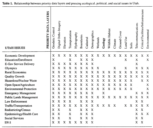
In Utah, the Geographic Information Systems Advisory Council, which encompasses federal, state, and local government, academia, and the private sector, has led the statewide data coordination effort under a joint agreement forged in 1997. At that time the state and nine federal agencies signed a memorandum of understanding to cooperate in the production, acquisition, and dissemination of GIS data, creating the Utah Framework Implementation Team (Utah I-Team). Over the next two years, the Utah I-Team defined the 18 priority layers listed in Table 1, assigned responsibilities, set goals, developed budgets and schedules, and set standards. They also established the primary target scale for all data as 1:24,000. In the process of setting goals and working with the agencies they represent, they identified many of the State's most serious issues. The Utah I-Team then determined which data themes are required to successfully address each issue. This analysis is summarized in Table 1. The first three issues in the table represent the Governor's top priorities.
BUILDING THE GEOLOGY FRAMEWORK LAYER
In explaining how to build a geology framework, we will the use the Utah plan as our example. The Utah Geological Survey (UGS) has been a member of the Utah I-Team from its inception, but did not play a major role until early 2001. At that time, as the Utah I-Team plan gradually took shape, the UGS was requested to develop a detailed model and plan for the geologic framework layer.
Geologic maps
Geologic hazards (most were in GIS format)
Geologic resources
CONCLUSIONS AND RECOMMENDATIONS
The I-Team framework plan addresses the needs of the GIS community in most states, multistate associations, and geographic-oriented groups. I-Teams are commonly looked upon as the primary source of GIS data for most government policy-making and management decisions. Commonly, I-Teams are the loudest voice in legislative and other decision-making circles, influencing funding and setting local and state GIS standards and procedures. Although geology is only a small part of this much larger GIS community, we believe that it is important for geological surveys and other geology groups to actively seek out, join, and then promote geologic issues on I-Teams in their state or region.
In defining and creating geology layers for your I-Team Framework plan, we recommend the following:
ACKNOWLEDGMENTS
RETURN TO Contents
National Cooperative Geologic
Mapping Program | Geologic Division |
Open-File Reports
U.S. Department of the Interior, U.S. Geological Survey
URL: https://pubsdata.usgs.gov/pubs/of/2002/of02-370/kennelly1.html
Maintained by David R. Soller
Last modified: 19:15:42 Wed 07 Dec 2016
Privacy statement | General disclaimer | Accessibility