1U.S. Geological Survey
908 National Center
Reston, VA 20192
Telephone: (703) 648-6907
Fax: (703) 648-6937
e-mail: drsoller@usgs.gov
2Ohio Geological Survey
4383 Fountain Square Dr.
Columbus, OH 43224
Telephone: (614) 265-6988
Fax: (614) 268-3669
e-mail: thomas.berg@dnr.state.oh.us
The National Geologic Mapping Act of 1992 and its reauthorizations in 1997 and 1999 (PL106-148) require that a National Geologic Map Database (NGMDB) be designed and built by the U.S. Geological Survey (USGS), in cooperation with the Association of American State Geologists (AASG) and other entities participating in the National Cooperative Geologic Mapping Program. The Act notes that the NGMDB is intended to serve as a "national archive" of geologic maps, to provide to a wide variety of people, from private citizens to professional geologists, the information needed to address various societal issues. The Act requires the NGMDB to also include the following related map themes: geophysics, geochemistry, paleontology, and geochronology. In this progress report, the term "geoscience" is used to refer to these five map themes.
In mid-1995, the general stipulations in the Act were addressed in the proposed design and implementation plan developed within the USGS and the Association of American State Geologists (AASG). This plan was summarized in Soller and Berg (1995). Because many maps are not yet in digital form and because many organizations produce and distribute geologic maps, it was decided to develop the NGMDB in several phases.
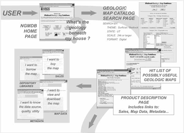
The first and most fundamental phase includes a comprehensive, searchable Catalog of all geoscience maps in the United States, whether in either paper or digital format. Figure 1a shows how the Map Catalog can be used to find a particular geologic map. Upon searching the NGMDB Catalog and identifying the needed map(s), the user is linked to the map data, the metadata, or to the appropriate organization for information about how to purchase the map. (The organization could be a participating state or federal agency, association, university, or private company.) The Map Catalog presently is supported by two databases developed under the NGMDB project: (1) GEOLEX, a searchable geologic names lexicon; and (2) Geologic Mapping in Progress, which provides information on current mapping projects, prior to inclusion of their products in the Map Catalog. In the coming year, an Image Library will be prototyped and made available to the public; this new initiative is described below. Plans for the prototype National Paleontology Database also are discussed below.
|
Figure 1. Diagram showing how a user might navigate the NGMDB Map Catalog and the online map database.
a. The user, interested in knowing something about the geology of an area (e.g., the land beneath his house), queries the Map Catalog, which returns a hit list of possibly useful maps. The user selects a map entry and, from the Product Description Page, obtains further information and can choose to either buy the map, view and download it, or inspect the metadata. The dark arrow toward the bottom of the figure points toward the online map database (Figure 1b).
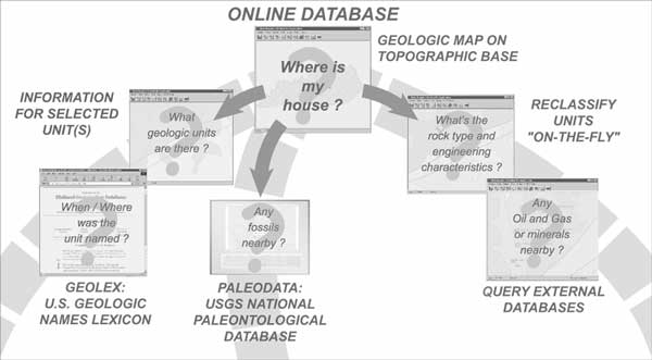
b. The user queries the online map database. (Note: the paths along these queries are shown as dashed lines, to indicate planned development.) From the initial display showing the geology of the area surrounding his house, the user might choose to reclassify those units in order to derive a map showing engineering properties or query the geologic data in relation to external databases (here, an oil and gas database). Further, the user might be interested in the history of a particular geologic name or the availability of fossils; if so, the online map database would connect to GEOLEX or the National Paleontology Database. |
The second phase of the project focuses on public access to digital geoscience maps, and on the development of digital map standards and guidelines needed to improve the utility of those digital maps. The third phase proposes, in the long term, to develop an online, "living" database of geologic map information at various scales and resolution. Some functions of the planned online database, and its links to databases developed under Phase One, are shown in Figure 1b.
In late 1995, work began on Phase One. The formation of several Standards Working Groups in mid-1996 initiated work on Phase Two. Progress was summarized in Soller and Berg (1997, 1998, 1999a, 1999b, 2000, and 2001). At the Digital Mapping Techniques '98 through '02 workshops, a series of presentations and discussion sessions provided updates on the NGMDB and, specifically, on the activities of the Standards Working Groups. This report summarizes progress since the project's inception, but focuses on accomplishments since mid-2001. Further and more current information may be found at the NGMDB project-information Web site, at http://ncgmp.usgs.gov/ngmdbproject/. The searchable database is available at http://ngmdb.usgs.gov/.
To submit general comments about project scope and direction, please address the authors directly (see above). For technical comments on the databases or Web page design, please use our Web feedback form; this form is linked from many of our search pages (e.g., see "Your comments are welcome," at http://ngmdb.usgs.gov/).
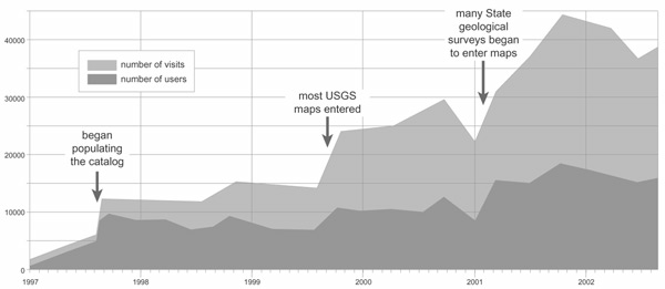
Figure 2. Web-usage statistics for the Map Catalog, GEOLEX, and Mapping in Progress Databases. The Map Catalog accounts for roughly 75-80% of the usage. |
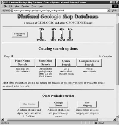
Soon after the DMT '02 meeting, the Map Catalog search page was extensively revised. It now addresses the diverse needs of our user audience through four search options (Figure 3). The easy-to-use Place Name Search is designed to address the needs of nongeologists who want to use a simple interface to find information about their home, town, or worksite, whereas the Comprehensive Search offers researchers a full range of search criteria.
|
Figure 3. The new Map Catalog home page, showing the four search methods -- Place Name, State Geologic Maps, Quick Search, and Comprehensive Search. |
GEOLEX is intended to be the comprehensive, authoritative listing of approved geologic names and is available as a resource for geologic mappers nationwide. Many state geological surveys have been registering new geologic names with the USGS for decades and are encouraged to continue this practice under GEOLEX, through a Web-based application form.
If we view the project's Map Catalog and online map databases (Phase 3) as endpoints on a spectrum of complexity and ease-of-use, it is obvious that a significant gap exists between them. The Map Catalog exists today; it is relatively straightforward to use and it simply provides bibliographic information about each geoscience map product. In contrast, the online map database is still in its formative, prototype stage; when publicly available, it will provide full access to detailed geologic-map information, but many users may not be sufficiently familiar with geoscience concepts to comfortably use it. This is a serious concern, as this project seeks to address the needs of all users, of various backgrounds and interests. As noted below, the AASG and USGS are working together to build the foundation for the online map database, through development of the necessary technology, science concepts and data model, and a collection of widely distributed digital geologic-map coverage.
In the middle ground along this spectrum, we have the opportunity to provide users with geologic-map information in a raster image format, thereby allowing them Web access to the familiar paper map format we've known for generations (Figure 4). Therefore, we have begun a new project initiative, to build a library of geologic map images. The images will be managed in high-quality compressed format, using MrSID technology. To deliver this information, we are beginning to design a prototype database and Web site to allow users to find and view geologic maps (Figure 5). At present, we anticipate providing the capability for searching by quadrangle (e.g., 1:24,000, 1:100,000, 1:250,000-scale) and by county. Our efforts will focus on providing images of general-purpose bedrock and surficial geologic maps.
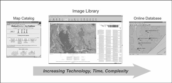
Figure 4. The proposed Image Library occupies a middle ground between the Map Catalog and the online map database in regard to technological complexity, ease-of-use, and related issues. It will provide users with geologic map information in a familiar image format. |
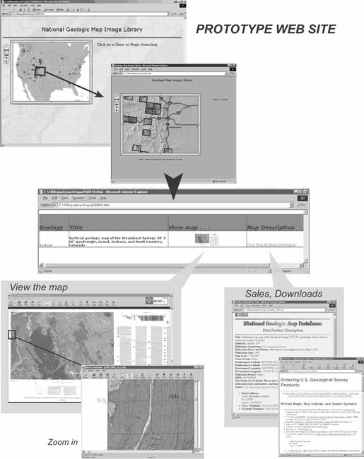
Figure 5. Diagram showing how users could access the proposed Image Library to view high-quality images of published bedrock- and surficial-geology maps. The user would select a state of interest and then a quadrangle within that state; that selection would generate an information table that listed the available map products. For each map product, the table would provide links to the image ("View map . . .") and to the map�s record in the Map Catalog ("Map Description"). A user interested in purchasing a paper copy or downloading a digital version of the map can easily do so because the Map Catalog page includes the necessary information and links. |
The Image Library will link directly to the Map Catalog and the Geologic Mapping in Progress Database. As evident in Figure 5, through these links we intend to direct users to the agencies producing the maps. We hope this initiative will further strengthen the cooperative relationship between the AASG and USGS.
To design an online database, project personnel have held numerous discussions with geoscientists and the general public to gauge interest in an online database and to define its scope. Based on these discussions, it is clear that this database should be:
The online map database is being designed to integrate with other databases developed under this project. For example, a user accessing the online map database might identify a map unit of interest and then want to purchase or download the original, published map product, or inquire about fossils found within that unit or the history of the unit's geologic name. These user questions exploit the power and flexibility of the databases, and we anticipate building into the system the functionality diagrammed in Figure 6. As another example of the interaction of the various NGMDB phases, this diagram shows that a user might access the Map Catalog and identify a map of interest; the user might then purchase the map or link to a map server where the product can be downloaded. In the latter case, the arrow passing through "Standards Development" indicates that the NGMDB project's standards-development activities affect the content and format of products served.
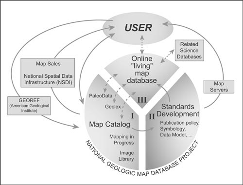
Figure 6. Diagram showing user access to the various components of the National Geologic Map Database (NGMDB) project and to related external databases and services. The three project phases and the relations among them are shown. Dashed arrows indicate planned relations. |
_______ 1998, Digital Mapping Techniques '98 -- Workshop Proceedings: U.S. Geological Survey Open-File Report 98-487, 134 p., https://pubs.usgs.gov/openfile/of98-487/.
_______ 1999, Digital Mapping Techniques '99 -- Workshop Proceedings: U.S. Geological Survey Open-File Report 99-386, 216 p., https://pubs.usgs.gov/openfile/of99-386/.
_______ 2000, Digital Mapping Techniques '00 -- Workshop Proceedings: U.S. Geological Survey Open-File Report 00-325, 209 p., https://pubs.usgs.gov/openfile/of00-325/.
_______ 2001, Digital Mapping Techniques '01 -- Workshop Proceedings: U.S. Geological Survey Open-File Report 01-223, 248 p., https://pubs.usgs.gov/of/2001/of01-223/.
Soller, D.R., and Berg, T.M., 1995, Developing the National Geologic Map Database: Geotimes, v. 40, no. 6, p. 16-18.
_______ 1997, The National Geologic Map Database -- a progress report: Geotimes, v. 42, no. 12, p. 29-31.
_______ 1998, Progress Toward Development of the National Geologic Map Database, in Soller, D.R., ed., Digital Mapping Techniques '98 -- Workshop proceedings: U.S. Geological Survey Open-File Report 98-487, p. 37-39, https://pubs.usgs.gov/openfile/of98-487/soller2.html.
_______ 1999a, Building the National Geologic Map Database: progress and challenges, in Derksen, C.R.M., and Manson, C.J., eds., Accreting the continent's collections: Geoscience Information Society Proceedings, v. 29, p. 47-55, http://ncgmp.usgs.gov/ngmdbproject/reports/gisproc98.html.
_______ 1999b, The National Geologic Map Database -- a progress report, in Soller, D.R., ed., Digital Mapping Techniques '99 -- Workshop Proceedings: U.S. Geological Survey Open-File Report 99-386, p. 31-34, https://pubs.usgs.gov/openfile/of99-386/soller1.html.
_______ 2000, The National Geologic Map Database -- a progress report, in Soller, D.R., ed., Digital Mapping Techniques '00 -- Workshop Proceedings: U.S. Geological Survey Open-File Report 00-325, p. 27-30,https://pubs.usgs.gov/openfile/of00-325/soller2.html.
_______ 2001, The National Geologic Map Database -- a progress report, in Soller, D.R., ed., Digital Mapping Techniques '01 -- Workshop Proceedings: U.S. Geological Survey Open-File Report 01-223, p. 51-57, https://pubs.usgs.gov/of/2001/of01-223/soller1.html.
Soller, D.R., Berg, T.M., and Wahl, Ron, 2000, Developing the National Geologic Map Database, Phase 3 -- an online, "Living" database of map information, in Soller, D.R., ed., Digital Mapping Techniques '00 -- Workshop Proceedings: U.S. Geological Survey Open-File Report 00-325, p. 49-52, https://pubs.usgs.gov/openfile/of00-325/soller4.html.
Soller, D.R., Duncan, Ian, Ellis, Gene, Giglierano, Jim, and Hess, Ron, 1999, Proposed guidelines for inclusion of digital map products in the National Geologic Map Database, in Soller, D.R., ed., Digital Mapping Techniques '99 -- Workshop Proceedings: U.S. Geological Survey Open-File Report 99-386, p. 35-38, https://pubs.usgs.gov/openfile/of99-386/soller2.html.
Soller, D.R., and Lindquist, Taryn, 2000, Development and public review of the draft "Digital Cartographic Standard for Geologic Map Symbolization," in Soller, D.R., ed., Digital Mapping Techniques '00 -- Workshop Proceedings: U.S. Geological Survey Open-File Report 00-325, p. 43-47, https://pubs.usgs.gov/openfile/of00-325/soller3.html.
Soller, D.R., Wahl, Ron, Weisenfluh, Jerry, Brodaric, Boyan, Hastings, Jordan, Laudati, Robert, and Fredericks, Roger, 2001, Progress report on the National Geologic Map Database, Phase 3: an online database of map information, in Soller, D.R., ed., Digital Mapping Techniques '01 -- Workshop Proceedings: U.S. Geological Survey Open-File Report 01-223, p. 71-78, https://pubs.usgs.gov/of/2001/of01-223/soller2.html.
Wahl, R.R., Soller, D.R., and Yeldell, Steven, 2000, Prototype implementation of the NADMSC Draft Standard Data Model, Greater Yellowstone area, in Soller, D.R., ed., Digital Mapping Techniques '00 -- Workshop Proceedings: U.S. Geological Survey Open-File Report 00-325, p. 57-63, https://pubs.usgs.gov/openfile/of00-325/wahl.html.
Wardlaw, B.R., Stamm, N.R., and Soller, D.R., 2001, The U.S. Geological Survey National Paleontological Database, in Soller, D.R., ed., Digital Mapping Techniques '01 -- Workshop Proceedings: U.S. Geological Survey Open-File Report 01-223, p. 59-70, https://pubs.usgs.gov/of/2001/of01-223/wardlaw.html.