
![]()
Wisconsin Aeromagnetic Index Map and Data Table
![]()
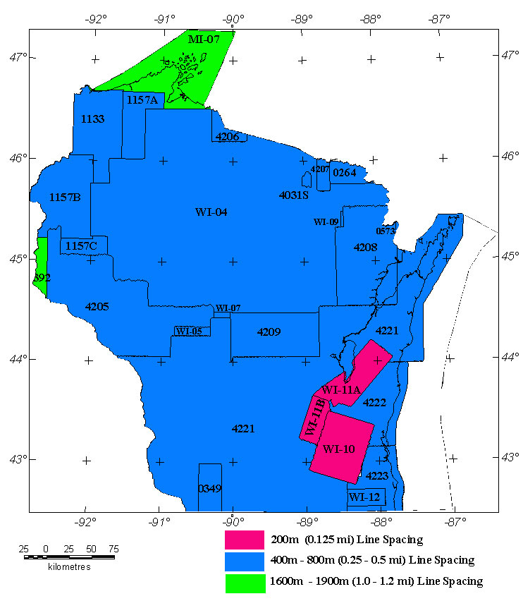
The Wisconsin aeromagnetic map contains data from 26 separate aeromagnetic surveys. The above map is an index to the locations of the surveys. Refer to the table below for additional facts. Publication references are listed in the bibliography. Seven of the earlier surveys are analog and have been digitized from contour maps. Files of most digitized analog surveys may be downloaded from the USGS site: http://greenwood.cr.usgs.gov/pub/open-file-reports/ofr-99-0557/html/mag_home.html. Digital flight line data for most surveys flown since about 1973 are available from the USGS site: https://pubs.usgs.gov/of/2002/ofr-02-361/. Images of the high-resolution surveys (WI-10, WI-11), shown as pink on the above map, may be viewed directly.
Table of Wisconsin Aeromagnetic Surveys
| Grid* resolution | Flown by | Data Source - References | ||||||||
|---|---|---|---|---|---|---|---|---|---|---|
| 0264 | Analog | Florence | USGS | 06/1956-07/1956 | 0.25 mi. | N-S | 500 ft AG | Total field, arbitrary datum | digitized contour map: USGS, 1999 | |
| 0349 | Analog | Wis. Lead-Zinc West | USGS | 07/1960 | 0.25 mi. | N-S | 1800 ft Bar | Total field, arbitrary datum | digitized contour map, King and others, 1966 | |
| 0392 | Analog | Elk River ARMS | USGS | 08/1961-09/1961 | 1 mi. | E-W | 500 ft AG | Total field, arbitrary datum | digitized contour map: USGS, 1999 | |
| 0573 | Analog | Menominee | USGS | 06/1966 | 0.5 mi. | N-S | 500 ft AG | Total field, arbitrary datum | digitized contour map: USGS, 1999 | |
| 1133 | Digital | Northwest Wisconsin | 200m | USGS | 06/1988-07/1988 | 0.5 mi. | N-S | 300 ft AG | DIGRF | Hittleman, and others, 1992 |
| 1157A | Digital | Northern Wisconsin '96 | 200m | USGS | 08/1996-09/1996 | 0.5 mi. | N-S | 500 ft AG | DIGRF | Snyder, 2001 |
| 1157B | Digital | West Wisconsin '96 | 200m | USGS | 08/1996-09/1996 | 0.5 mi. | N-S | 500 ft AG | DIGRF | Snyder, 2001 |
| 1157C | Digital | West-Central Wisc '96 | 200m | USGS | 08/1996-09/1996 | 0.5 mi. | N-S | 500 ft AG | DIGRF | Snyder, 2001 |
| 4031S | Digital | Sturgeon EM | 100m | Geoterrex | 1980 | 0.25 mi. | N-S | 400 ft AG | IGRF80 | USGS, 1981 |
| 4205 | Digital | West-Central Wisconsin | 200m | Aero Surveys | 02/1998-03/1998 | 0.5 mi. | N-S | 1000 ft AG | DIGRF | Daniels and others, 1999 |
| 4206 | Digital | Ironwood Fill-In | 200m | Aero Surveys | 10/1997 | 0.5 mi. | N-S | 1000 ft AG | DIGRF | Daniels and others, 1999 |
| 4207 | Digital | West Florence Fill-In | 200m | Aero Surveys | 10/1997 | 0.5 mi. | N-S | 1000 ft AG | DIGRF | Daniels and others, 1999 |
| 4208 | Digital | Northeastern Wisconsin | 200m | Aero Surveys | 10/1997-12/1997 | 0.5 mi. | N-S | 1000 ft AG | DIGRF | Daniels and others, 1999 |
| 4209 | Digital | Central Wisconsin '97 | 200m | Aero Surveys | 11/1997-02/1998 | 0.5 mi. | N-S | 1000 ft AG | DIGRF | Daniels and others, 1999 |
| 4221 | Digital | S and NE Wisconsin | 200m | High Sense | 11/1998-02/1999 | 0.5 mi. | N-S | 1000 ft AG | IGRF95 | Bracken and Nicholson, 1991 |
| 4222 | Digital | WI Eastern Shore | 200m | High Sense | 09/1998-02/1999 | 0.5 mi. | N-S | 1000 ft AG | IGRF95 | Bracken and Nicholson, 1991 |
| 4223 | Digital | SE Wisconsin | 200m | High Sense | 02/1999 | 0.5 mi. | E-W | 1000 ft AG | IGRF95 | Bracken and Nicholson, 1991 |
| MI-07 | Digital | Lake Superior GLIMPCE | Canada | 06/1987 | 1.2 mi. | N-S | 1000 ft AG | DIGRF | Teskey and others, 1991 | |
| WI-04 | Grid | North-central Wisconsin | Univ. Wisc. | 1975? | 0.5 mi. | N-S | 500 ft AG | IGRF65 | Karl and others, 1993 | |
| WI-05 | Analog | Central Wisconsin '61 N. | Fairchild | 04/1961 | 0.5 mi. | N-S | 500 ft AG |
DGRF |
digitized contour map: unpub. | |
| WI-07 | Analog | Marshfield | Scintrex | 12/1971-2/1972 | 0.25 mi. | N-S | 175 ft AG |
? |
digitized contour map: unpub. | |
| WI-09 | Analog | Potawotomi | Appl.Geophys | 8/1980 | 0.25 mi. | N-S | 300 ft AG | IGRF75 | digitized contour map: unpub. | |
| WI-10 | Digital | Oconomowoc Area | 50m | High Sense | ? | 0.125 mi. | N105E | 500 ft AG |
IGRF80(?) |
Mudrey, 1996a |
| WI-11A | Digital | Fond du Lac Area A | 50m | High Sense | ? | 0.125 mi | N40E | 500 ft AG |
IGRF80(?) |
Mudrey, 1996b |
| WI-11B | Digital | Fond du Lac Area B | 50m | High Sense | ? | 0.125 mi. | NW-SE | 500 ft AG |
IGRF80(?) |
Mudrey, 1996b |
| WI-12 | Digital | SE Wisconsin | 250m | Mobil | 1984? | 0.5 mi. | E-W | 2000 ft Bar | IGRF80 | Mudrey, 1998 |
* Resolution of downloadable grids
** AG= above ground (drape) survey; Bar= barometric (level) survey
|| Wisconsin Mag Page || USGS - Eastern Minerals Team || USGS - Geology || USGS - Home Page ||