Open-File Report 03-85
GIS Description Regional Data Mapped areas |
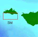
AbstractThe nearshore benthic habitat of the Santa Barbara coast and Channel Islands supports diverse marine life that is commercially, recreationally, and intrinsically valuable. Some of these resources are known to be endangered including a variety of rockfish and the white abalone. Agencies of the state of California and the United States have been mandated to preserve and enhance these resources. Data from sidescan sonar, bathymetry, video and dive observations, and physical samples are consolidated in a geographic information system (GIS). The GIS provides researchers and policymakers a view of the relationship among data sets to assist scienctific research and to help with economic and social policy-making decisions regarding this protected environment. IntroductionIn 1980, Congress designated Anacapa, San Miguel, Santa Barbara, Santa Cruz and Santa Rosa Islands and 125,000 acres of submerged lands extending 1 nautical mile (nmi) offshore as the Channel Islands National Park because they possess unique natural and cultural resources. Also in 1980, a 1,252 square-nautical-mile area of the Santa Barbara Channel was designated as the Channel Islands National Marine Sanctuary (CINMS). The CINMS encompasses an area from the mean high-tide line out to six nautical miles around the islands of San Miguel, Santa Rosa, Santa Cruz, and, Anacapa and seaward of the city of Santa Barbara. The sanctuary's objectives are to enhance resource protection, preserve natural beauty, and preserve the bounty of marine ecosystems. Since 1999, the CINMS has collaborated with the California Department of Fish and Game (CDFG) to produce a plan for the establishment of marine reserves, or no-take zones, around the northern Channel Islands. This follows the establishment of several Marine reserves along the California coast (CDFG and CINMS, 2001). The U.S. Geological Survey (USGS) has conducted a research project in the sanctuary since 1999 to map the marine geological environment (Cochrane and others, 2002). The focus of the USGS study is on the broad, flat continental shelf, areas shallower than 100 m (328 ft), between Point Arguello to the north and Point Dume to the south and around the northern Channel Islands. The project tasks focused on mapping the seafloor with sidescan sonar and diver observations, collecting video data in the survey areas, and compiling existing sediment sample data. Polygon areas classified be bottom habitat were generated from this research. The mapping areas for this first volume of the GIS were dictated by the establishment of marine ecological reserves at Vandenberg and Big Sycamore Canyon (Figure 1), and the Marine Ecological Reserves Research Program (MERRP), created by the CDFG and administered by the California Sea Grant College Program (Vetter and others, 2002). Since the types of habitat and the condition of the fish communities contained within these nearshore reserves were not fully known, two additional study sites were added. The rationale was to include an island site (San Miguel Island) that contained rocky habitat within the cold temperate Oregonian biogeographic province (Vetter and others, 2002) that could serve as a comparison to the Vandenberg site (Anacapa Island) and an island site that contained rocky habitat within the warm temperate San Diegan biogeographic province (Vetter and others, 2002) for comparison with the Big Sycamore site. This geographic information system (GIS) compilation presents the results of sidescan sonar mapping of the seafloor, and video and diver transect observations, in the four study areas (Figure 1). Revisions and UpdatesThis GIS compilation will be revised and updated as new data become available. The most flexible way to do this will be to post changes on the internet (online). Versions will be published online and links to each will be available at http://walrus.wr.usgs.gov/nearshorehab. To check on the volume and version of your GIS look at Revision History. The hosting site could change. If there is no forwarding link, go the the USGS home page and search for keywords Southern California habitat. File and Data FormatsText files (.txt) on the web site may be viewed without special software. Hypertext mark-up language files (.html) require a browser such as Netscape Navigator or Internet Explorer. GIF (.gif), JPEG (.jpg) or TIFF (.tif) images may be viewed by many common image software packages. The data files require ESRI ArcExplorer, ArcView, or Arc/Info. ArcExplorer, is an application that ESRI licenses without charge for Windows operating systems. ArcView and ArcInfo are licensed applications that must be purchased. The data were compiled in ArcInfo (version 8.0.2, ESRI, 1982-2000), a commercial GIS, in the UTM Zone 10 coordinate system with datum NAD83. Raster data layers are in ArcInfo GRID format or are registered TIFF images. Point, line and polygon features are in ESRI shapefile format. Shapefiles were generated in geographic coordinates with datum NAD83 for the ArcView 3.2a project. Each data layer is accompanied by FGDC-compliant metadata and an overview map. AcknowledgmentsThe authors would like to thank the staff of the CINMS for their support of this project. Mike Boyle, Fred Payne and others at the USGS Western Region Marine Facility expertly assisted with the acquistion and logistics. We would also like to thank the crews of the NOAA R/V MacArthur, NOAA R/V Ballena, and the UCSD R/V Sproul. Visual observations were contributed by the projects of Russ Vetter, and John Butler of the U.S. National Marine Fisheries Service. Submersible time for bottom video was contributed by Sylvia Earle and the NOAA Sustainable Seas Expedition. Use of an ROV was provided by the Santa Clara University Extreme Environment Mechanisms Lab. Florence Wong provided HTML and GIS design guidance and a review of this publication. ReferencesBlondel, P., 1996. Segmentation of the Mid-Atlantic Ridge south of the Azores, based on acoustic classification of TOBI data, in MacLeod, C.J., Tyler, P.A., and Walker, C.L. (Eds.), Tectonic, Magmatic, Hydrothermal and Biological Segmentation of Mid-Ocean Ridges: Boulder, CO, Geological Society Special Publication No. 118, p. 17-28. Blondel, P., and Murton, B.J., 1997. Handbook of Seafloor Sonar Imagery: West Sussex, England, 314 p. CDFG and CINMS, California Department of Fish and Game, Channel Islands
National Marine Sanctuary, 2001, A recommendation for Marine Protected
Areas in the Channel Islands National Marine Sanctuary, Chavez, P. S., Jr., 1984. U.S. Geological Survey mini image processing system (MIPS). U.S. Geological Survey Open-File Report 84-880, pp. 12 p. Cochrane, G.R., Vetter, R.D., Nasby, N.M., Taylor, C.A., and Cosgrove, R., 2002, Benthic habitats in four marine-reserve locations surrounding the Santa Barbara Basin. Final Report Part II. in, Marine Ecological Reserves Research Program: Research Results 1996-2001, California Sea Grant, CDROM. PDF file Cochrane, G.R. and Lafferty, K. D., 2002, Use of acoustic classification
of sidescan sonar data for mapping benthic habitat in the Northern Channel
Islands, California: Continental Shelf Research, v. 22, p. 683-690. Greene, G.H., Yoklavich, M.M., Starr, R.M., O‘Connell, V.M., Wakefield, W.W., Sullivan, D.E., McRea, J.E., and Cailliet, G.M., 1999, A classification scheme for deep seafloor habitats. Oceanologica Acta, v. 22, p. 663-678. Reid, J. A., Jenkins, C., Field, M. E., Gardner, J. V. and Box, C. E. 2001.
USSEABED: defining the surficial geology of the continental shelf through data
integration and fuzzy set theory. Geological Society of America Annual Meeting,
Boston, MA. Abstracts with Programs 33:A106. Shokr, M.E., 1991, Evaluation of second-order texture parameters for sea ice classification from radar images: Journal of Geophysical Research, v. 96, p. 10625-10640. USGS, 1998, http://walrus.wr.usgs.gov/infobank/b/b198sc/html/b-1-98-sc.meta.html USGS, 1999, http://walrus.wr.usgs.gov/infobank/b/b199sc/html/b-1-99-sc.meta.html USGS, 2000, http://walrus.wr.usgs.gov/infobank/m/m100sc/html/m-1-00-sc.meta.html Vetter, R.D., Moser, H.G., Watson, W., Cochrane, G.R., Nasby, N., Taylor, C., Cosgrove, R., 2002, Egg and Larval fish production from marine ecological reserves, in, Marine Ecological Reserves Research Program: Research Results 1996-2001, California Sea Grant, CDROM. PDF file For more information, contactGuy R. Cochrane |

![]() U.S. Department of the Interior |
U.S. Geological Survey
U.S. Department of the Interior |
U.S. Geological Survey
URL: http://pubsdata.usgs.gov/pubs/of/2003/0085/intro.html
Page Contact Information: GS Pubs Web Contact
Page Last Modified: Tuesday, 01-Apr-2014 16:35:38 EDT