 Introduction Introduction
This geologic database of the Redlands 7.5' quadrangle was prepared by the Southern California Areal Mapping Project (SCAMP), a regional geologic-mapping project sponsored jointly by the U.S. Geological Survey and the California Geological Survey. The database was developed as a contribution to the National Cooperative Geologic Mapping Program's National Geologic Map Database, and is intended to provide a general geologic setting of the Redlands quadrangle. The database and map provide information about earth materials and geologic structures, including faults and folds that have developed in the quadrangle due to complexities in the San Andreas Fault system.
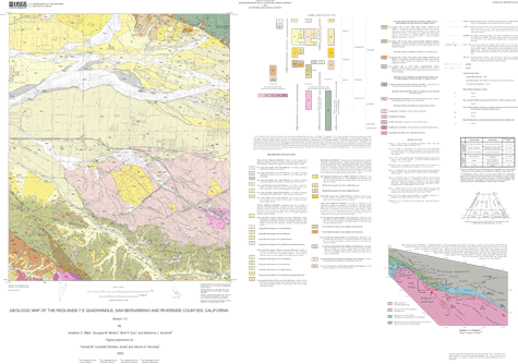
The Redlands 7.5' quadrangle contains earth materials and structures that provide insight into the late Cenozoic geologic evolution of the southern California Inland Empire region. Important stratigraphic and structural elements include (1) the modern trace of the San Andreas and San Jacinto faults and (2) late Tertiary and Quaternary sedimentary materials and geologic structures that formed during the last million years or so and that record complex geologic interactions within the San Andreas Fault system. These materials and the structures that deform them provide the geologic framework for investigations of earthquake hazards and ground-water recharge and subsurface flow. Geologic information contained in the Redlands database is general-purpose data that is applicable to land-related investigations in the earth and biological sciences. The term "general-purpose" means that all geologic-feature classes have minimal information content adequate to characterize their general geologic characteristics and to interpret their general geologic history. However, no single feature class has enough information to definitively characterize its properties and origin. For this reason the database cannot be used for site-specific geologic evaluations, although it can be used to plan and guide investigations at the site-specific level.
This summary pamphlet discusses major categories of surficial materials in the Redlands quadrangle, and provides a conceptual framework and basis for how geologicmap units containing such materials are recognized and correlated.
|
First posted September 11, 2003
Data
Files for Viewing and Plotting
The National Geologic Map Database has additional data about this publication
Part or all of this report is presented in Portable Document Format (PDF). For best results viewing and printing PDF documents, it is recommended that you download the documents to your computer and open them with Adobe Reader. PDF documents opened from your browser may not display or print as intended. Download the latest version of Adobe Reader, free of charge.
|

