Poppe, Lawrence J. , Paskevich, Valerie, and Hastings, Polly, 2004, USGSECSTDB: USGS East Coast Sediment Texture Database: U. S. Geological Survey, Coastal and Marine Geology Program, Woods Hole Science Center, Woods Hole, MA.This is part of the following larger work.Online Links:
- <http://pubs.usgs.gov/of/2003/of03-001/data/seddata/usgsecstdb/usgsecstdb.zip>
- <http://pubs.usgs.gov/of/2003/of03-001/htmldocs/data.htm>
Poppe, L.J., Paskevich, V.F., Williams, S.J., Hastings, M.E., Kelley, J.T., Belknap, D.F., Ward, L.G., FitzGerald, D.M., and Larsen, P.F., 2003, Surficial Sediment Data from the Gulf of Maine, Georges Bank, and vicinity: a GIS Compilation: Open-File Report 03-001, U.S. Geological Survey, Coastal and Marine Geology Program, Woods Hole Science Center, Woods Hole, MA.Online Links:
This is a Vector data set. It contains the following vector data types (SDTS terminology):
Horizontal positions are specified in geographic coordinates, that is, latitude and longitude. Latitudes are given to the nearest 0.00001. Longitudes are given to the nearest 0.00001. Latitude and longitude values are specified in Decimal degrees.
The horizontal datum used is North American Datum of 1927.
The ellipsoid used is Clarke 1866.
The semi-major axis of the ellipsoid used is 6378206.400000.
The flattening of the ellipsoid used is 1/294.978698.
Sequential unique whole numbers that are automatically generated.
Coordinates defining the features.
Character string of width 7. Field contains USGS assigned sample ID consisting of alphanumerics.
Character string of width 18.
Character string of width 24.
Character string of width 19.
Character string of width 13.
| Value | Definition |
|---|---|
| BOSTON HARBOR | Boston Harbor area |
| BUZZARDS BAY | Buzzards Bay area |
| CONTINENTAL SHELF | Continental Shelf area |
| GEORGES BANK | Georges Bank |
| GULF OF MAINE | Gulf of Maine region |
| MAINE | offshore State of Maine |
| MAINE (POPHAM/KENNEBEC) | Popham and Kennebec Maine region |
| MASS BAY | Massachusetts Bay area |
| MASSACHUSETTS | Offshore Massachusetts |
| MASSACHUSETTSBAY | Massachusetts Bay area |
| MUDPATCH | "mudpatch" area south of Martha's Vineyard |
| OCEANOGRAPHER CANYON | Oceanographer Canyon |
| STELLWAGEN | Stellwagen Bank National Marine Sanctuary region |
| STELLWAGEN BANK | Stellwagen Bank National Marine Sanctuary region |
| STELLWAGEN BASIN | Stellwagen Bank National Marine Sanctuary region |
Character string of width 32.
| Range of values | |
|---|---|
| Minimum: | 39.34217 |
| Maximum: | 44.433 |
| Units: | signed decimal degrees |
| Resolution: | .000001 |
| Range of values | |
|---|---|
| Minimum: | -71.95 |
| Maximum: | -65.533 |
| Units: | signed decimal degrees |
| Resolution: | .000001 |
| Value | Definition |
|---|---|
| blank | Depth value is unknown or not recorded. |
| Range of values | |
|---|---|
| Minimum: | 0.0000 |
| Maximum: | 2609.0000 |
| Units: | meters |
| Resolution: | .0001 |
| Value | Definition |
|---|---|
| blank | Top depth value is unknown or not recorded. |
| Range of values | |
|---|---|
| Minimum: | 0.00 |
| Maximum: | 1100.00 |
| Units: | centimeters |
| Resolution: | 0.01 |
| Value | Definition |
|---|---|
| blank | Bottom depth value is unknown or not recorded. |
| Range of values | |
|---|---|
| Minimum: | 0.5 |
| Maximum: | 1100 |
| Units: | centimeters |
| Resolution: | 0.1 |
| Value | Definition |
|---|---|
| ?SCALLOP DREDGE | possible Scallop Dredge |
| GRAB SAMPLER | Grab Sampler |
| GRAVITY CORER | Gravity Corer |
| HAND SAMPLE | hand sample |
| HYDROSTATIC CORER | Hydrostatic Corer |
| OTHER | other or unknown sampling device |
| PULSE AUGER | pulse auger sampling device |
| PUSH CORER | push corer |
| SMITH-MACINTYRE GRAB | Smith MacIntyre Grab sampler |
| SUBMERSIBLE SAMPLE | sample collected via submersible |
| UNKNOWN | sample collected by unknown device |
| VAN VEEN | Van Veen Grab Sampler |
Character string of width 22.
| Value | Definition |
|---|---|
| blank | Month sample collected unknown or not recorded. |
| Range of values | |
|---|---|
| Minimum: | 1 |
| Maximum: | 12 |
| Units: | integer count |
| Resolution: | 1 |
| Value | Definition |
|---|---|
| blank | Day unknown or not recorded. |
| Range of values | |
|---|---|
| Minimum: | 1 |
| Maximum: | 23 |
| Units: | integer count |
| Resolution: | 1 |
| Value | Definition |
|---|---|
| blank | Year sample was collected is unknown or not recorded. |
| Range of values | |
|---|---|
| Minimum: | 1967 |
| Maximum: | 2002 |
| Units: | integer count |
| Resolution: | 1 |
| Value | Definition |
|---|---|
| blank | Month sample was analyzed is unknown or not recorded. |
| Range of values | |
|---|---|
| Minimum: | 1 |
| Maximum: | 12 |
| Units: | month; integer count |
| Resolution: | 1 |
| Value | Definition |
|---|---|
| blank | Day sample was analyzed is unknown or not recorded. |
| Range of values | |
|---|---|
| Minimum: | 1 |
| Maximum: | 31 |
| Units: | day of month |
| Resolution: | 1 |
| Value | Definition |
|---|---|
| blank | Year sample was analyzed is unknown or not recorded. |
| Range of values | |
|---|---|
| Minimum: | 1978 |
| Maximum: | 2002 |
| Units: | year; integer count |
| Resolution: | 1 |
| Value | Definition |
|---|---|
| blank | Weight is unknown or not recorded. |
| Range of values | |
|---|---|
| Minimum: | 0 |
| Maximum: | 9086.1000 |
| Units: | grams |
| Resolution: | 0.0001 |
| Value | Definition |
|---|---|
| blank | Value is unknown or not recorded. |
| Range of values | |
|---|---|
| Minimum: | 0 |
| Maximum: | 100 |
| Units: | percent |
| Resolution: | 0.01 |
| Value | Definition |
|---|---|
| blank | Value is unknown or not recorded. |
| Range of values | |
|---|---|
| Minimum: | 0 |
| Maximum: | 100 |
| Units: | percent |
| Resolution: | 0.01 |
| Value | Definition |
|---|---|
| blank | Value is unknown or not recorded. |
| Range of values | |
|---|---|
| Minimum: | 0 |
| Maximum: | 100 |
| Units: | percent |
| Resolution: | 0.0001 |
| Value | Definition |
|---|---|
| blank | Value is unknown or not recorded. |
| Range of values | |
|---|---|
| Minimum: | 0 |
| Maximum: | 82.9 |
| Units: | percent |
| Resolution: | 0.0001 |
| Value | Definition |
|---|---|
| CLAYEY SAND | clayey sand content |
| CLAYEY SILT | clayey silt content |
| GRAVEL | gravel content |
| GRAVELLY SEDIMENT | gravelly sediment content |
| SAND | sand content |
| SAND SILT CLAY | sand silt-clay content |
| SANDY SILT | sandy-silt content |
| SILT | silt content |
| SILTY CLAY | silty clay content |
| SILTY SAND | silty sand content |
Character string of width 20 containing classification.
| Value | Definition |
|---|---|
| blank | Value is unknown or not recorded. |
| Range of values | |
|---|---|
| Minimum: | -5.19 |
| Maximum: | 10.01 |
| Units: | phi |
| Resolution: | 0.01 |
| Value | Definition |
|---|---|
| blank | Value is unknown or not recorded. |
| Range of values | |
|---|---|
| Minimum: | -4.50 |
| Maximum: | 8.95 |
| Units: | phi |
| Resolution: | 0.01 |
| Value | Definition |
|---|---|
| blank | Value is unknown or not recorded. |
| Range of values | |
|---|---|
| Minimum: | 0.00 |
| Maximum: | 4.92 |
| Units: | phi |
| Resolution: | 0.01 |
| Value | Definition |
|---|---|
| blank | Value is unknown or not recorded. |
| Range of values | |
|---|---|
| Minimum: | -3.28 |
| Maximum: | 348.61 |
| Units: | phi |
| Resolution: | .01 |
| Value | Definition |
|---|---|
| blank | Value is unknown or not recorded. |
| Range of values | |
|---|---|
| Minimum: | -77093.80 |
| Maximum: | 5612.87 |
| Units: | phi |
| Resolution: | .01 |
| Value | Definition |
|---|---|
| blank | Value is unknown or not recorded. |
| Range of values | |
|---|---|
| Minimum: | -5.50 |
| Maximum: | 9.50 |
| Units: | phi |
| Resolution: | .01 |
| Value | Definition |
|---|---|
| blank | Value is unknown or not recorded. |
| Range of values | |
|---|---|
| Minimum: | 7.27 |
| Maximum: | 1773 |
| Units: | phi |
| Resolution: | .01 |
| Value | Definition |
|---|---|
| blank | Value is unknown or not recorded. |
| Range of values | |
|---|---|
| Minimum: | -5.50 |
| Maximum: | 9.50 |
| Units: | phi |
| Resolution: | .01 |
| Value | Definition |
|---|---|
| blank | Value is unknown or not recorded. |
| Range of values | |
|---|---|
| Minimum: | 0 |
| Maximum: | 34.67 |
| Units: | phi |
| Resolution: | .01 |
| Value | Definition |
|---|---|
| blank | Value is unknown or not recorded. |
| Range of values | |
|---|---|
| Minimum: | -5.50 |
| Maximum: | 9.50 |
| Units: | phi |
| Resolution: | .01 |
| Value | Definition |
|---|---|
| blank | Value is unknown or not recorded. |
| Range of values | |
|---|---|
| Minimum: | 7.27 |
| Maximum: | 1773 |
| Units: | phi |
| Resolution: | .01 |
| Value | Definition |
|---|---|
| blank | Value is unknown or not recorded. |
| Range of values | |
|---|---|
| Minimum: | 0 |
| Maximum: | 3 |
| Units: | integer count |
| Resolution: | 1 |
| Value | Definition |
|---|---|
| blank | Value is unknown or not recorded. |
| Range of values | |
|---|---|
| Minimum: | -5 |
| Maximum: | 9 |
| Units: | phi |
| Resolution: | 1 |
| Value | Definition |
|---|---|
| blank | Value is unknown or not recorded. |
| Range of values | |
|---|---|
| Minimum: | -4 |
| Maximum: | 11 |
| Units: | phi |
| Resolution: | 1 |
| Value | Definition |
|---|---|
| blank | Value is unknown or not recorded. |
| Range of values | |
|---|---|
| Minimum: | 0.81 |
| Maximum: | 61.76 |
| Units: | percent |
| Resolution: | .01 |
| Value | Definition |
|---|---|
| blank | Value is unknown or not recorded. |
| Range of values | |
|---|---|
| Minimum: | 0.00 |
| Maximum: | 100.00 |
| Units: | percent |
| Resolution: | .01 |
| Value | Definition |
|---|---|
| blank | Value is unknown or not recorded. |
| Range of values | |
|---|---|
| Minimum: | 0 |
| Maximum: | 56.02 |
| Units: | percent |
| Resolution: | .01 |
| Value | Definition |
|---|---|
| blank | Value is unknown or not recorded. |
| Range of values | |
|---|---|
| Minimum: | 0.00 |
| Maximum: | 47.54 |
| Units: | percent |
| Resolution: | .01 |
| Value | Definition |
|---|---|
| blank | Value is unknown or not recorded. |
| Range of values | |
|---|---|
| Minimum: | 0 |
| Maximum: | 84.97 |
| Units: | percent |
| Resolution: | .01 |
| Value | Definition |
|---|---|
| blank | Value is unknown or not recorded. |
| Range of values | |
|---|---|
| Minimum: | 0.00 |
| Maximum: | 78.26 |
| Units: | percent |
| Resolution: | .01 |
| Value | Definition |
|---|---|
| blank | Value is unknown or not recorded. |
| Range of values | |
|---|---|
| Minimum: | 0.00 |
| Maximum: | 92.67 |
| Units: | percent |
| Resolution: | .01 |
| Value | Definition |
|---|---|
| blank | Value is unknown or not recorded. |
| Range of values | |
|---|---|
| Minimum: | 0.00 |
| Maximum: | 85.92 |
| Units: | percent |
| Resolution: | .01 |
| Value | Definition |
|---|---|
| blank | Value is unknown or not recorded. |
| Range of values | |
|---|---|
| Minimum: | 0.00 |
| Maximum: | 95.92 |
| Units: | percent |
| Resolution: | .01 |
| Value | Definition |
|---|---|
| blank | Value is unknown or not recorded. |
| Range of values | |
|---|---|
| Minimum: | 0.00 |
| Maximum: | 90.60 |
| Units: | percent |
| Resolution: | .01 |
| Value | Definition |
|---|---|
| blank | Value is unknown or not recorded. |
| Range of values | |
|---|---|
| Minimum: | 0.00 |
| Maximum: | 84.54 |
| Units: | percent |
| Resolution: | .01 |
| Value | Definition |
|---|---|
| blank | Value is unknown or not recorded. |
| Range of values | |
|---|---|
| Minimum: | 0.00 |
| Maximum: | 67.85 |
| Units: | percent |
| Resolution: | .01 |
| Value | Definition |
|---|---|
| blank | Value is unknown or not recorded. |
| Range of values | |
|---|---|
| Minimum: | 0.00 |
| Maximum: | 47.57 |
| Units: | percent |
| Resolution: | .01 |
| Value | Definition |
|---|---|
| blank | Value is unknown or not recorded. |
| Range of values | |
|---|---|
| Minimum: | 0 |
| Maximum: | 47.90 |
| Units: | percent |
| Resolution: | .01 |
| Value | Definition |
|---|---|
| blank | Value is unknown or not recorded. |
| Range of values | |
|---|---|
| Minimum: | 0 |
| Maximum: | 45.55 |
| Units: | percent |
| Resolution: | .01 |
| Value | Definition |
|---|---|
| blank | Value is unknown or not recorded. |
| Range of values | |
|---|---|
| Minimum: | 0 |
| Maximum: | 51.31 |
| Units: | percent |
| Resolution: | .01 |
| Value | Definition |
|---|---|
| blank | Value is unknown or not recorded. |
| Range of values | |
|---|---|
| Minimum: | 0 |
| Maximum: | 50.55 |
| Units: | percent |
| Resolution: | .01 |
| Value | Definition |
|---|---|
| blank | Value is unknown or not recorded. |
Character string of width 14.
Character string of width 90.
The U.S. Geological Survey must be referenced as the originator of the dataset in any future products or research derived from these data.
(508) 548-8700 x2289 (voice)
(508) 457-2310 (FAX)
[email protected]
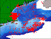
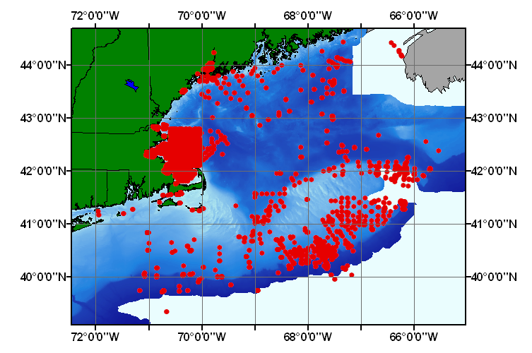
This ArcView shapefile contains the locations of marine sediment samples collected and analyzed by the U.S. Geological Survey, Woods Hole Science Center starting in 1980 thru 2002. Distribution of this dataset allows the user the ability to visualize the information in a Geographic Information system.
Hastings, M.E. (Polly) , 20000500, USGS East-Coast Sediment Analysis: Procedures, Database, and Georeferenced Displays: USGS Open-File Report 00-358, U.S. Geological Survey, Coastal and Marine Geology Program, Woods Hole Science Center, Woods Hole, MA.This is part of the following larger work.Online Links:
Poppe(ed.), L.J., and Polloni(ed.), C.F., 20000500, U.S. Geological Survey East-Coast Sediment Analysis: Procedures, Database, and Georeferenced Displays: Open-File Report 00-358, U.S. Geological Survey, Coastal and Marine Geology Program, Woods Hole Science Center, Woods Hole, MA.Online Links:
The modified Excel spreadsheet file, usgsecstdb.xls, was exported as an ASCII text file with tab delimited fields.
Person who carried out this activity:
(508) 548-8700 x2281 (voice)
(508) 457-2310 (FAX)
[email protected]
Data sources produced in this process:
Person who carried out this activity:
(508) 548-8700 x2281 (voice)
(508) 457-2310 (FAX)
[email protected]
Data sources produced in this process:
Person who carried out this activity:
(508) 548-8700 x2314 (voice)
(508) 457-2310 (FAX)
[email protected]
Data sources produced in this process:
Person who carried out this activity:
508-548-8700 x2314 (voice)
508-457-2310 (FAX)
[email protected]
Data sources produced in this process:
(ed.), L.J. Poppe , and (ed.), C.F. Polloni , 2000, USGS East-Coast Sediment Analysis: Procedures, Database, and Georeferenced Displays: Open-File Report 00-358, U.S. Geological Survey, Coastal and Marine Geology Program, Woods Hole Science Center, Woods Hole, MA.Online Links:
Samples collected prior to about 1990 were navigated by Loran C (absolute navigational accuracy about 100 m); samples collected after 1990 were navigated by Differential GPS (navigational accuracy about 10 m).
This data set is a subset of the complete USGS East Coast Sediment Texture Database described and released via U.S. Geological Survey Open-File Report 00-358.
No additional checks for topological consistency were performed on this data.
Are there legal restrictions on access or use of the data?
- Access_Constraints: None
- Use_Constraints:
- Public domain data from U.S. government is freely redistributable with proper metadata and source attribution.
(508) 548-8700 x2314 (voice)
(508) 457-2310 (FAX)
[email protected]
Regional Mapping of Surficial Sediments: Gulf of Maine and Georges Bank, Aggregates and Habitats Projects, usgsecstdb.shp USGS East-Coast Sediment Analysis: Procedures, Database, and Georeferenced Displays, 2000, U.S. Geological Survey Open-File Report 00-358; East Coast Sediment Texture Database, 05_00pnt.shp
Although this derived data set and it's lineage dataset have been used by the USGS, no warranty, expressed or implied, is made by the USGS as to the accuracy of the data and/or related materials. The act of distribution shall not constitute any such warranty, and no responsibility is assumed by the USGS in the use of these data or related materials.
| Data format: | Five files (usgsecstdb.dbf, usgsecstdb.shp, usgsecstdb.shx, usgsecstdb.sbn, usgsecstdb.sbx) comprising the ArcView point shapefile components, 'prj' and 'avl' files, metadata text file and browse graphic. in format ArcView (version 3.2) ESRI Shapefile Size: 18.875 |
|---|---|
| Network links: | |
| Media you can order: |
CD-ROM
(Density 650
Mbyte)
(format ISO9660)
Note: The user must have a computer system with a CD-ROM available. To browse the information contained on this CD-ROM, the user must have a current WWW browser available. The user must also have software installed on their computer to unzip the archived file.
|
The data is available in ArcView shapefile format. The user must have ESRI's ArcView 3.0 or later software to read and process this data file. In lieu of ArcView, the user may utilize another GIS application package capable of importing data.
(508) 548-8700 x2289 (voice)
(508) 457-2310 (FAX)
[email protected]
Regional Mapping of Surficial Sediments: Gulf of Maine and Georges Bank, Aggregates and Habitats Projects, usgsecstdb.shp USGS East-Coast Sediment Analysis: Procedures, Database, and Georeferenced Displays, 2000, U.S. Geological Survey Open-File Report 00-358; East Coast Sediment Texture Database, 05_00pnt.shp
Although this derived data set and it's lineage dataset have been used by the USGS, no warranty, expressed or implied, is made by the USGS as to the accuracy of the data and/or related materials. The act of distribution shall not constitute any such warranty, and no responsibility is assumed by the USGS in the use of these data or related materials.
| Data format: | Microsoft Excel (version Office 2000) Microsoft Excel spreadsheet |
|---|---|
| Network links: |
<http://pubs.usgs.gov/openfile/of00-358> |
| Media you can order: |
CD-ROM
(Density 650
Mbyte)
(format ISO9660)
Note: The user must have a computer system with a CD-ROM available. To browse the information contained on this CD-ROM, the user must have a current WWW browser available. The user must also have software installed on their computer to unzip the archived file.
|
The data is available in ArcView shapefile format. The user must have ESRI's ArcView 3.0 or later software to read and process this data file. In lieu of ArcView, the user may utilize another GIS application package capable of importing data.
(508) 548-8700 x2281 (voice)
(508) 457-2310 (FAX)
[email protected]