OF 03-150 Home
CD-ROM
Contents
Project
Description
GIS Data
Contacts
|
GIS Data
3D Views
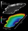 |
| Figure 10. Three-dimensional view of the
sidescan-sonar and bathymetric data collected within Bear Lake, Utah-Idaho |
Interactive Visualization Systems (IVS) Fledermaus software suite was used to drape the sidescan-sonar
data on the bathymetric surface. By adding height information (depth)
to the backscatter data, the imagery can be viewed in three dimensions;
greatly improving data interpretation. The Fledermaus software
suite also enables the user to 'fly through' the study area, presenting
unique perspectives, and again, improving data interpretation.
IVS produces a free viewer, iView3D, that will read
files generated by the Fledermaus software suite. Two Fledermaus
object files and one scene file have been included
on this CD-ROM. These data can be viewed through the IVS free program,
iView3D. The user is encouraged to download iView3D
in order to view the geophysical data acquired in Bear Lake, in a three-dimensional
perspective.
Download Information:
- Go to the IVS
website
- Go to Products
- Click on iView3D
This will take the User to the iView3D Home Page.
The User will find a program description and detailed downloading
instructions. It is highly recommended that the User download
iView3D in order to view the sidescan-sonar and
bathymetric data in three dimensions and 'fly-through' the study
area. The HELP within iView3D gives detailed
operating instructions.
Fledermaus Object and Scene Files:
The following files are stored within the ivs
directory and can be viewed within
iView3D. See iView3D HELP for
detailed instructions on loading and manipulating data files.
- 3d.scene - bathymetry and sidescan-sonar
- sidescan.sd - sidescan-sonar image
- bathy.sd - bathymetric data
|