Skip past header information
USGS Logo with link to USGS Home Page
USGS Open-File Report 03-254, High-Resolution Subsurface Imaging of Coastal Barriers

Back to Main Page

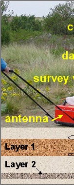
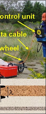
Figure 1. Ground-penetrating radar in the field. The system shown here is the GSSI SIR-2000 GPR with a 200 MHz transceiver antenna, the device that both generates and receives the electromagnetic signal. The frequency and wavelength (λ) of the signal determine the penetration and resolution of the subsurface image.

Figure 1. Ground-penetrating radar in the field. Figure 1. Ground-penetrating radar in the field.

Skip Footer Information
Department of Interior
 /  U.S. Geological Survey  /  Coastal and Marine Geology / 

USGS Privacy Statement  /  Disclaimer  /  Accessibility
This is http://pubs.usgs.gov/pubs/of/2003/of03-254/fig1.html
Maintained by Eastern Publications Group
Modified Saturday, 12-Jan-2013 23:27:03 EST