 USGS Woods Hole Science Center Coastal and Marine Program USGS Open-File Report 03-254
PDF version [1.4 MB] of this information sheet. High-Resolution Subsurface Imaging of Coastal Barriersby Ilya V. Buynevich
Coastal barriers and tidal inlets are among the most dynamic coastal environments. Understanding the processes that reshape our beaches and that are responsible for coastal erosion and formation of new inlets, particularly during intense storms, will provide the necessary framework for forecasting coastal behavior. Conventionally, geological signatures of coastal change have been identified by analysis of the landscape features, extensive coring efforts, or historical documents. In many cases, however, surficial signatures of erosional shorelines and inlet channels may be drastically modified or obliterated by natural or human-induced processes. Sediment cores are expensive to obtain and provide isolated data points that often miss subsurface features of limited spatial extent, such as concentrations of heavy minerals diagnostic of buried storm scarps. With the advent of new subsurface imaging technology, such as ground-penetrating radar (GPR; Fig. 1), continuous high-resolution records of subsurface barrier architecture can be obtained in a short amount of time, with penetration depths of up to 20 m. In the picture above, both the top and bottom interfaces of layer 1 will be resolved because its thickness is comparable to the wavelength of the signal, whereas only the upper surface of layer 2 may be revealed. Increasing the emitted frequency (e.g., using a 400 MHz antenna instead of 200 MHz) may help resolve layer 2; however the decreased penetration depth of the higher frequency signal may become a limiting factor. GPR method
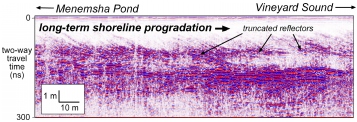
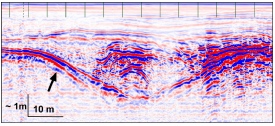
Ground-penetrating radar is in many ways similar to seismic-reflection profiling, except that it uses electromagnetic (EM), rather than acoustic waves, in the frequency range from 10 to 2000 MHz. In effect, the radar signal provides an "X-ray" view of the sediment layers and shallow rock structure in a variety of environmental settings. Sediment characteristics that affect the subsurface behavior of EM waves include pore-water and clay mineral content and their chemical composition, as well as magnetic properties of constituent minerals. Varying degrees of textural and compositional heterogeneity of sediments in many coastal sequences produce the lithological contrast necessary to generate subsurface reflections. Similar to other subsurface techniques, there is a trade-off between the penetration and resolution of the imaged sequence, with higher-frequency signals providing lower penetration and better resolution than in the lower frequency range (Fig. 1). Using continuous GPR profiles, high-resolution images of shoreline progradation and erosion surfaces (Fig. 2), buried inlet channels (Fig. 3), and sedimentary sequences in coastal lakes and ponds can be obtained in a matter of minutes. This technique may also be used to detect local incursions of seawater into shallow coastal aquifers. Because most of the environmental history in the coastal regions is archived in sedimentary sequences, geologic studies complemented by GPR profiles, aid scientists in deciphering the records of ancient storms and help to delineate former shoreline positions.
Coastal sequences along many of the world's continental and insular margins provide excellent natural laboratories for detailed stratigraphic analysis using subsurface imaging tools. Despite the attenuation of the EM signal by saltwater, relatively high permeability and width of many barrier systems allow for freshwater conditions to dominate the shallow subsurface, making GPR a viable imaging tool in these settings. In recent years, ground-penetrating radar technology, complemented with sediment cores and integrated with seismic and resistivity databases, has been used successfully in coastal-stratigraphic research along the west coast of the United States (USGS/Menlo Park) and along the east coast (USGS/Woods Hole) in collaboration with scientists from local universities and the Woods Hole Oceanographic Institution. Such studies have already significantly improved our understanding of coastal dynamics over a wide range of temporal and spatial scales and are helping to unravel the complexity of coastal processes and resulting stratigraphic records.
This report is preliminary and has not been reviewed for conformity with U.S. Geological Survey editorial standards or with the North American Stratigraphic code. Any use of trade, product, or firm names is for descriptive purposes only and does not imply endorsement by the U.S. Government. 
|