USGS Open-File Report 03-254, High-Resolution Subsurface Imaging of Coastal Barriers
Back to
Main Page
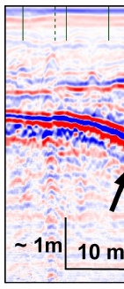
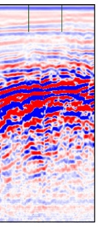
Figure 3. Shore-parallel radar image reveals a buried inlet channel at Oyster Pond, upper Cape Cod, Massachusetts.
Note the complex channel fill bounded by the prominent channel-margin reflector (arrow).
|