
|
This is a report of geochemical data from various media collected on Isle Royale, a large island in northeastern Lake Superior. Isle Royale became a national park in 1940 and was designated as a wilderness area in 1976. USGS sampling began in 1996 as part of a larger project on the Midcontinent Rift in the Lake Superior region. Data are given in nine Microsoft Excel spreadsheets. All the data are newly acquired by the USGS. |
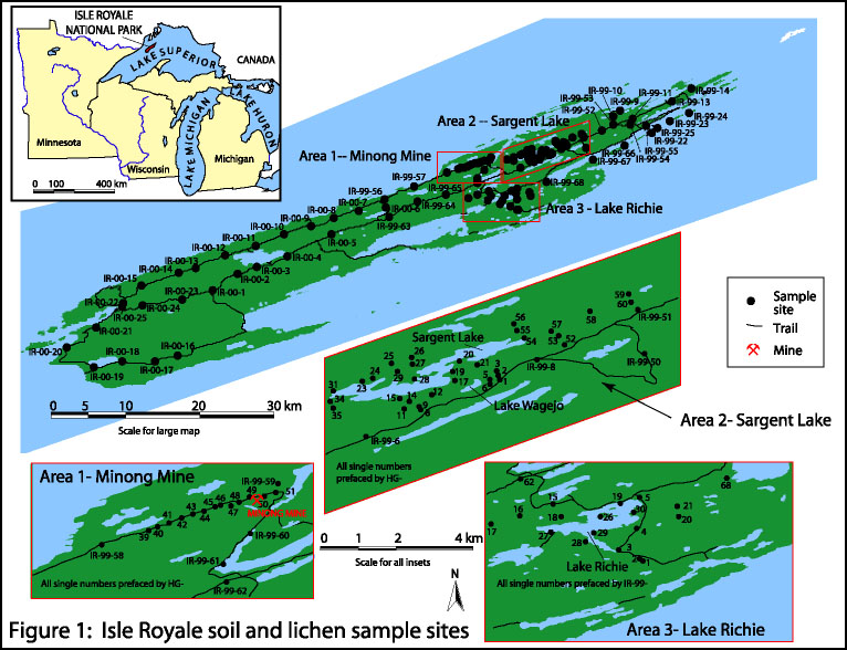 |
| Map showing the location of study area and distribution of soil and lichen sample sites for which analyses are reported. |
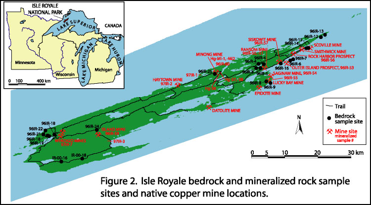 |
| Map showing the location of study area and distribution of bedrock and mineralized rock sample sites for which analyses are reported. |
|
FILES
|
DESCRIPTION
|
|
Word document format of open file report
|
|
|
Portable Document Format (PDF) of open file report
|
|
|
Metadata in text format
|
|
FILES
|
DESCRIPTION
|
|
Geochemical analyses of A-horizon and E-horizon mineral soils
|
|
|
Geochemical analyses of C-horizon mineral soils
|
|
|
Geochemical analyses of sediment lake core collected from Lake Richie, Isle Royale
|
|
|
Geochemical analyses of four lichen species
|
|
|
Geochemical analyses of rocks, sediment, and stamp sands with minor native copper mineralization collected from mineralized veins and mine dumps
|
|
|
Geochemical analyses of organic O-horizon organic material
|
|
|
Geochemical analyses of sediment lake core collected from Sargent Lake, Isle Royale
|
|
|
Geochemical analyses of sandstone and conglomerate matrix collected from the Copper Harbor Formation
|
|
|
Geochemical analyses of basalt, andesite and rhyolite from the Portage Lake Volcanics exposed on Isle Royale
|
|
FILES
|
DESCRIPTION
|
|
Adobe Illustrator (ai) map showing the location of study area and distribution of soil and lichen sample sites for which analyses are reported.
|
|
|
Portable Document Format (PDF) map showing the location of study area and distribution of soil and lichen sample sites for which analyses are reported.
|
|
|
Adobe Illustrator (ai) map showing the location of study area and distribution of bedrock and mineralized sample sites for which analyses are reported.
|
|
|
Portable Document Format (PDF) map showing the location of study area and distribution of bedrock and mineralized sample sites for which analyses are reported.
|
|
Adobe Acrobat Reader is required to view Portable Document Files (PDF).
|
For questions, please contact Laurel G. Woodruff or William F. Cannon.