|
|
|
|
|
| Report Home | Maps | Overview | Mapping Methods | Coastal Classifications | Geologic Setting | Coastal Processes | Coastal Vulnerability | Classification Summary | References | |||||||||||||||||||||||||||||||
Coastal Classifications
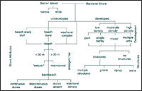
The coastal geomorphic classification (Fig. 2) emphasizes those physical factors that influence erosion, overwash of sandy beaches and barrier islands, and landward sediment transport during storms along and across those features. The natural coastal attributes that are considered to have the greatest influence on storm impact and landward sediment transport are:
Overwash Areas
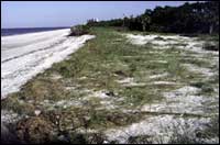
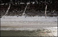
Dune Height (Elevation) and Continuity
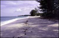
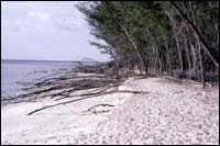
At some locations dune heights (elevations) vary along the beach. The high dune segments can block storm surge, whereas gaps in the dunes can divert high-velocity flow into low-lying areas that become washover conduits. Areas where dunes are either absent, or are low, discontinuous, and sparsely vegetated are prime candidates for overwash (Fig. 4). Dune heights (elevations) on the maps are given in units of decimeters. A decimeter is one-tenth of a meter. Beach WidthBeaches initially dissipate wave energy during the early stages of storm approach; consequently, beach width can influence the impacts of storms depending on storm intensity and duration. In general, wide beaches provide more protection than narrow beaches (Figs. 5 and 6).
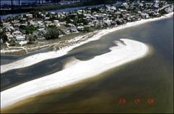
In most coastal areas, natural stable beaches are usually more than 30 m wide. Based on this observation, beach width was classified as being either greater or less than 30 m. The beach width category is perhaps the most subject to change of all the classifications because beaches are naturally dynamic, and their widths can be altered by human activities. Even since the initial mapping and field verification were completed, some beach segments that were less than 30 m wide are now much wider because of recent beach nourishment projects. Likewise, some beach segments that were more than 30 m wide at the time of mapping are now significantly more narrow. Emergent Bars
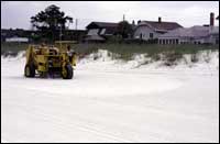
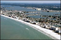
DevelopmentStorm impacts on coastal regions also depend locally on the type and density of coastal construction. This is because artificial structures and topographic modifications tend to complicate wave and current interactions, and can accentuate the destructive forces of the storm. When high-velocity currents encounter rigid structures, the currents typically are deflected or focussed, turbulence increases, and local scouring occurs. Widely-spaced and elevated buildings with small footprints cause minimal interactions with storm processes. In contrast, closely-spaced concrete pilings or massive foundations of large buildings, swimming pools, and coastal defense structures locally increase the erosion by focussing the flow between buildings and preventing the wave dissipating transfer of sand from the dunes to the beach and bars. Because hard structures do not store and release sand like dunes, more sand erodes from the beach to satisfy the capacity of the strong waves and currents. The map classifications pertaining to infrastructure and residential and commercial development are non-quantitative and rely on general differences between end members and intermediate categories. For example, high-density development (Fig. 8) represents many buildings per unit area with little or no green space (natural or landscaped) separating buildings. In contrast, low-density development represents only a few buildings (Fig. 9), usually isolated or scattered throughout an area that consists of natural topography and vegetation or is maintained. Moderate-density development represents those conditions that fall between high- and low-density development. A similar approach was taken to differentiate among areas dominated by single-family dwellings (houses), areas dominated by multiple-dwelling units (condominiums) or commercial development (hotels, restaurants, shops), and areas where both types of development are interspersed (mixed). Another classification uncertainty arises where extremely large houses are mistaken for small multiple dwelling units. Normally the architectural style and geographic location provide other evidence that can be used to make the distinction. Parks constitute a special map classification because they typically consist of large areas that are natural in their morphology and vegetation, but they also commonly contain parking lots, dune-walkovers, bathhouses, concession pavilions, and other man-made features.
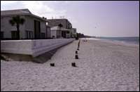
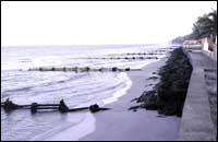
Beach Stabilization and StructuresMany landowners have attempted to protect their property from storm waves or persistent beach erosion by placing structures along the shore. The structures commonly used to protect individual lots or entire communities are walls (Fig. 10), riprap, and groins.
For mapping purposes, both seawalls and retaining walls (bulkheads) were included in the single generic classification of walls. Distinguishing between seawalls and retaining walls requires knowing their intended purpose and engineering design (holding back the sea or holding back the land). Because these distinctions cannot be determined from field inspection, the term wall is applied to all wall-like features constructed parallel to the shore regardless of their composition and shape. Riprap consists of broken rock or sometimes other hard material (concrete), that is placed on the backbeach parallel to the shore. Geotubes are composed of durable textile material formed into long cylinders that are filled with sand. The tubes, which are used instead of hard structures such as rip rap, are normally placed in the backbeach parallel to the shore. Walls, riprap, and geotubes can be buried either naturally or artificially beneath sand of the backbeach or dunes. Consequently there may be short beach segments where shore-parallel structures exist, but they are not visible and therefore are not included on the map. Groins are usually short features composed of concrete, broken rocks, or wood arranged perpendicular to the beach. Groins can be individual structures but they are commonly spaced along the shore to form a field of groins. Breakwaters are another shore-parallel structure constructed of concrete or rocks, but they are placed in the water seaward of the beach. They are designed so that the waves lose their energy breaking on the structure and not on the beach. The multiple structure classification is used to delineate those areas where more than one type of structure is present (Fig. 11). Jetties are structures constructed at tidal inlets that are intended to prevent sand from entering the navigation channels. They are usually constructed of large blocks of rock and aligned perpendicular to the beach. In some municipalities, runoff from streets and parking lots is transported to the beach by open-ended pipes. These storm-water outfalls are commonly constructed perpendicular to the beach, and they terminate in the backbeach or midbeach area. |