Link to USGS home page Link to USGS home page
Coastal and Marine Geology Program
Coastal & Marine Geology Program > Coastal Classification Mapping Project > Open File Report 03-322

Coastal Classification Atlas

Southwestern Florida Coastal Classification Maps - Venice Inlet to Cape Romano

USGS Open File Report 03-322

Robert A. Morton, Russell L. Peterson

Report Home Maps Overview Mapping Methods Coastal Classifications Geologic Setting Coastal Processes Coastal Vulnerability Classification Summary References
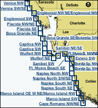
Introduction || City: Venice | Englewood | Placida | Port Boca Grande | Bokeelia | Captiva | Wulfert | Sanibel | Fort Myers Beach | Estero | Bonita Springs | Naples | Marco Island | Cape Romano
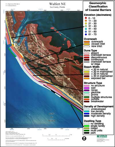
Coastal Classification Map Introduction

Each map shows an area with the coastal classifications marked as color bars along the shoreline. Below is an example map of Wulfert NE. To find out more about how the classification system works, see the Coastal Classifications section. At the right side of the page is a clickable index map that will take you to the other maps.

Example Coastal Classification map for Wulfert NE   index map
Clickable Index Map. Use the index map above to navigate to the different coastal areas.

Cape Romano NW/NEPlacida SEPlacida NW/NENaples South SENaples South NENaples North SW/SENaples North NWFort Myers Beach SEFort Myers Beach NW/NEMarco Island SWMarco Island OW W NE/Marco Island NWEstero SWEnglewood NW NE/Englewood NWCaptiva SWCaptiva NWPort Boca Grande SE/Bokeelia SWPort Boca Grande NEBonita Springs SWBonita Springs NWFort Myers Beach SESanibel NE/SESanibel SWSanibel SWWulfert NEWulfert NEWulfert NWSanibel NE/SEEnglewood SWVenice SW/SEVenice NW

Coastal & Marine Geology Program > Coastal Classification Mapping Project > Open File Report 03-322


[an error occurred while processing this directive]