Digital Mapping Techniques '03
— Workshop Proceedings
U.S. Geological Survey Open-File
Report 03–471
Conversion of Lithological Data in the Manitoba Water Well Database (GWDrill) to a Mappable Format
Geological Survey of Canada, 601 Booth Street, Ottawa ON K1A 0E8
*Current address: Minnesota Geological Survey, 2642 University Ave W., St Paul, MN 55114-1057
Telephone 612-627-4780 ext 224; fax: 612-627-4778; e-mail thorleif@umn.edu
ABSTRACT
A project designed to gain access to all usable data to aid construction of 3D geological models for southern Manitoba has included significant effort to appropriately utilize lithological data of variable quality in the Provincial water well database known as “GWDrill”. In order to use the data, it was necessary first to assign x, y, and z coordinates to each site on the basis of the existing designation, usually a quarter section (one-half mile by one-half mile) or river lot location. Secondly, it was necessary to convert the lithological data to a classification and terminology that could be queried and mapped. The lithological data were converted by correcting spelling, obtaining an inventory of words, deleting unusable words, identifying synonyms and changing them to a single term, and parsing and interpreting the remaining information into several lithological, colour, structure, consistency, hydrogeological, and stratigraphic variables. The resulting database has exceeded expectations with respect to apparent location accuracy and geological coherence.
INTRODUCTION
As a result of the foresight of Manitoba Water Resources Branch staff, the Province of Manitoba has an excellent digital database of water well records, known as GWDrill. The database includes several tables, including a table of verbal stratum descriptions. These lithological data typically appear unmodified from the driller’s reports, providing very useful site-specific information in the driller’s original wording.
Progress in application of computer-based mapping methods has, however, increased recognition that data would ideally also be formatted for use in these applications. In doing so, caution is required because data originally reported with a low level of certainty may be formatted for computer-based applications in a manner that implies a higher level of certainty than was originally intended. One approach to this challenge is to set up procedures that allow many drillholes to be viewed at once, allowing anomalous data to become more apparent. Doing so requires that sites be assigned x, y, and z coordinates so that sites can be graphically portrayed relative to each other, and that lithological data of varying format and terminology be translated to a set of attributes under which consistent, although evolving, terminology is used.
This paper describes an experiment in the implementation of this approach to the Manitoba water well database. The objective was to permit lithological data to be queried and mapped in 3D, thus aiding the construction of geological models for southern Manitoba.
LOCATION AND ELEVATION
Virtually all of the records in the database are located to a legal survey polygon such as a quarter section or a river lot, so a database of x and y locations for centroids of the legal survey polygons was required. Two formats are present: Dominion Land Survey (DLS) quarter sections, and Parishes, consisting of river lots and other survey systems that predate the DLS grid. Legal survey data obtained from Manitoba Conservation were used to obtain x and y values for the centroid of each polygon. Sites located to quarter sections were assigned the quarter section coordinates. Wells located to a section (1 mile by 1 mile) were assigned a location at the centroid of the section, obtained by averaging the quarter section xy values. Wells assigned locations no more specifically than section, for example to a township (6 miles by 6 miles), were not assigned coordinates for estimated location. Wells assigned to a river lot were given coordinates for the centroid of the lot. Where river lots are divided into two or more portions, such as inner and outer lots divided by a road, the average of the coordinates was used for a well whose legal survey location did not indicate which portion of the lot the well was located in.
Elevations were assigned by intersecting the legal survey polygon centroid x and y values with a digital elevation model derived from legal survey data that typically is accurate to ± 3 m.
PREPARATION OF THE DATA
Processing was first applied to a November 1998 version of the database that consisted of 83,597 sites (fig. 1) and 402,461 strata. Subsequently, the database was updated with a July 2000 version consisting of 87,992 sites and 422,917 strata. Ten sites that had occurred in the 1998 version had been deleted prior to release of the 2000 version, and 35 strata in the 1998 version do not appear in the 2000 version. Using both versions, a database of 88,002 sites and 422,943 strata resulted.
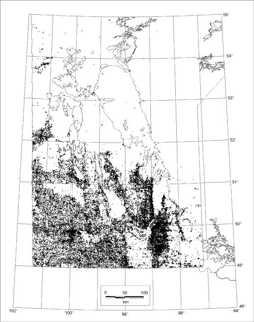 |
Figure 1. Location of GWDrill sites south of 55°N; 166 additional sites occur farther north. |
The database download in 1998 was acquired from Manitoba Water Resources Branch twice, due to media format problems. The first version used memo fields of unrestricted length for the lithologic description, whereas the subsequent version used 255 character text fields, among which 15 records were truncated. The truncated records were restored after a method was found to read the first download. In addition, the first version contained both UTM zones 14 and 15, whereas the second, which was implemented, exclusively used zone 14.
It was agreed by all involved that no changes would be made to the driller’s original lithological description as it appeared in the database, and Geological Survey of Canada (GSC) staff have no access to the permanent data archive. The intention was to generate a table of parsed information that could be linked to the original stratum file, with no change in the number of strata.
In addition to this table, however, an add-on table of zero-thickness strata was created to capture information regarding the nature of material at a lower contact. This information typically takes the form of a statement such as: 20 to 30' sand, rock at 30'. The new zero-thickness stratum was given an incremented sequence number, and the original description was modified in the add-on table, for example, sequence x, 20–30' sand, sequence x+1, 30–30', rock. These data were considered important for mapping the bedrock surface, as well as the top of Precambrian rock where it underlies Phanerozoic cover.
Records for the 88,002 sites include descriptions for 422,943 strata. An average of about 3 words is used per stratum, hence a total of about 1.2 million words occur in the original data. These words are arranged in 77,457 different combinations. Conversion of the lithological data commenced by correcting spelling errors using a word-processor spell-check of a copy of the descriptions. Having done so, the number of unique stratum descriptions was reduced to a total of 72,467. These records are constructed from 1,956 different words, excluding numbers and punctuation.
A table of these words was obtained by inserting a carriage return in a copy of the descriptions after all words, and by using database procedures to obtain a word inventory with frequency of occurrence. Each of the 1,956 words was classified with respect to whether the word was to be deleted, substituted with a synonym, or retained, and all words were classified with respect to a list of topics that emerged as the analysis progressed. These included lithological, colour, structure, consistency, hydrogeological, and stratigraphic variables.
Over half of the words were deleted, including terms such as ‘and’, ‘with’, and ‘of’ (table 1) that were of use in a phrase, but are not essential in parsed information. It should be noted that several thousand strata were re-interpreted in the late stages of processing on the basis of searches and inspection of the original description, and at this stage, the word ‘and’ was a factor. Hence some words that were deleted for the first iteration may later have been considered during a final iteration of interpretation.
| Table 1. Most commonly occurring words that were deleted, with frequency of occurrence. | |||||
|
AND |
64758
15199 11704 10715 8405 5240 1688 1684 1187 1080 946 785 762 733 608 521 500 498 480 468 428 403 399 398 373 362 362 362 345 323 306 274 266 242 233 230 228 207 205 195 |
AS HEAVY LIKE RIVER MAINLY CAVING DUG PURE HIGHLY SMOOTH AFTER LAKE THAN ZONE GRAINS GOOD THROUGHOUT PACKED OCCASIONAL MATERIAL MINOR BASE HOLE OPEN LACUSTRINE COLOUR BACK NUMEROUS TOP MUCH ON BELOW GPM NICE BECOMING BUT IS LOOSELY BIT INCHES |
189 189 179 173 171 163 162 162 152 146 144 140 137 136 134 132 132 129 127 124 120 119 115 115 113 107 105 105 102 102 100 98 96 95 95 94 94 92 92 91 |
CHANGING MATRIX FINER DRILL LESS LOST IGPM LOSS DRILLED TAKING SAME HIGH MODERATELY AMOUNT ALMOST IT REPORTED TURNING SIZE LOOKS PROBABLY GETTING DARKER BIG SEMI POORLY UNKNOWN SURFACE PLATES LOSING PREDOMINATE THE POSSIBLY ETC. SHARP DIAMETER OFF BETWEEN DECAY NEAR |
90 90 88 86 85 85 84 82 82 81 80 79 79 74 74 71 71 70 70 69 69 68 67 66 65 63 63 63 63 63 63 62 61 61 59 59 58 58 58 57 |
Over one-third of the words were synonyms, and were changed to common terms. Among terminology related to lithology (table 2), the words most commonly replaced were synonyms of ‘gravel’, including 21 different words. Other words that occurred in many synonym forms are ‘previous well’, ‘fill’, and ‘fossiliferous’. Some synonym replacements are at equal levels of specificity, such as ‘hardpan’ and ‘till’, while other substitutions are from differing levels, such as ‘fossiliferous’ and ‘stromatolitic’.
| Table 2. Lithology-related synonyms that were changed to common terms, with frequency of occurrence in parentheses. | ||
|
GRAVEL
|
11593
|
stones (5818), pebbles (3249), cobbles (597), fragments (538), pieces (275),
particles (269), chips (267), bits (244), cobble (135), pebble (70),
granular (34), cobblestones (24), granules (23), cobblestone (16), gravels
(11), clasts (7), granulars (7), chip (5), chippings (2), aggregate (1),
gravel-cobbles (1)
|
|
TILL/DIAMICT
|
10328
|
hardpan (10213), till-like (62), tilly (41), colluvium (3), semihardpan (3),
tillish (3), tills (2), claybound (1)
|
|
SOIL
|
6630
|
topsoil (5289), loam (934), sod (274), dirt (85), earth (15), roots (12), vegetation
(11), manure (5), turf (3), mould (1), soils (1)
|
|
GRAVELLY
|
6208
|
stoney (5607), pebbley (577), cobbley (18), stonier (6)
|
|
UNDIFFERENTIATEDROCK
|
4332
|
bedrock (2531), stone (1748), caprock (51), sedimentary (2)
|
|
INTRUSIVE OR HIGH GRADE METAMORPHIC
|
3789
|
granite (3343), granitic (333),
igneous (90), schist (9), gneiss (8), pegmatite
(4), diorite(2)
|
|
PREVIOUS-WELL
|
2369
|
well (1259), old (667), existing (227), casing (31), previously (29), crib (28),
cribbed (26), excavated (24), abandoned (23), cribbing (16), cased (15),
previous (8), pipe (8), deepened (4), trench (3), wells (1)
|
|
BOULDER(S)
|
1749
|
rocks (1743), block (3), boulders-cobbles (2), blocks (1)
|
|
SILICA/SILICEOUS
|
1578
|
silica (889), quartz (621), siliceous (54), agate (7), agates (3), tripolized
(1), quartzose (1), silica-like (1), chalcedony (1)
|
|
BENTONITIC SHALE/MUDSTONE
|
1052
|
bentonite(1052)
|
|
FILL
|
889
|
road (364), backfill (291), roadbed (136), concrete (28), ash (23), pavement
(9), asphalt (8), roadfill (6), driveway (5), rockfill (3), culvert (3),
garbage (2), backfilled (2), sawdust (2), landfill (1), fill-type (1),
runway (1), bricks (1), roadway (1), junk (1), dike (1)
|
|
EVAPORITES
|
788
|
gypsum (752), gyprock (21), anhydrite (15)
|
|
CARBONATE
|
783
|
lime (763), tyndall (8), carb (6), carbonates (5), calcarenite (1)
|
|
DOLOSTONE
|
756
|
dolomite(737),dolostone(19)
|
|
SAND
|
549
|
quicksand (482), beach (22), sands (21), grit (21), alluvium (2), sand-like
(1)
|
|
LOW GRADE METASEDIMENTARY OR METAVOLCANIC
|
431
|
soapstone (223), slate (118),
volcanic (33), greenstone (18), quartzite (11),
marble (9), basalt (9), metamorphic (7), andesite
(1), argillite (1), volcanics (1)
|
|
CLEAN
|
400
|
washed (249), cleaner (149), cleaned (1), cleanest (1)
|
|
FINE-TO MEDIUM
|
360
|
fine-medium (253), medium-fine (106), fine-medium-fine(1)
|
|
UNCLASSIFIED
|
297
|
log (297) (inherited from ‘no log’ after ‘no’ was deleted)
|
|
FOSSILIFEROUS
|
264
|
shells (163), shell (51), clam (12), fossils (12), fossil (7), snail (7), bone
(3), crinoid (2), brachiopods (2), bones (1), mollusk (1), snails (1),
stromatolitic (1), vertebrae (1)
|
|
PEAT/ORGANIC
|
258
|
muskeg (85), swamp (75), muck (33), moss (30), quagmire (17), swampy (16), peatmoss
(2)
|
|
SULPHIDE-BEARING
|
257
|
pyrite (228), pyritic (12), pyrites (5), sulfide (5), marcasite (2), arsenopyrite
(2), sulfides (1), ore (1), metallic (1)
|
|
MEDIUM-TO COARSE
|
238
|
medium-coarse (232), coarse-medium(6)
|
|
SOFT CLAY
|
236
|
gumbo(183), putty(53)
|
|
FINE-TO COARSE
|
220
|
fine-coarse (215), coarse-fine (3), fine-medium-coarse (2)
|
|
SILTY CLAY)
|
217
|
mud(216),silt-clay(1)
|
|
UNDIFFERENTIATED SOIL/SEDIMENT
|
217
|
overburden (168), drift (19), sediment (18), surficial (7), sediments (4), regoliths
(1)
|
|
SANDY
|
193
|
gritty (184), sandier (5), loamy (4)
|
|
WOOD-BEARING
|
182
|
wood (179), woody (2), stump (1)
|
|
SHALE/MUDSTONE
|
181
|
siltstone (105), shale-like (31), shales (28), claystone (7), mudstone (4), quartz-shale
(2), clay-shale (2), shalestone (1), diatomaceous (1)
|
|
BOULDERY
|
179
|
rocky (179)
|
|
CLAYEY
|
154
|
muddy (113), clayed (25), clayish (14), clay-type (1), clayier (1)
|
|
COAL
|
144
|
lignite (142), coals (2)
|
|
PETROLIFEROUS
|
144
|
oily (112), oil (27), petroleum (4), hydrocarbons (1)
|
|
FERRUGINOUS
|
137
|
iron (77), oxide (30), hematite (17), oxides (10), ferrous (1), sideritic (1),
ironstone (1)
|
|
CONCRETIONARY/NODULAR
|
114
|
nodules (49), concretions (33), concretion (29), nodular (3)
|
|
WELL SORTED/GRADED)
|
71
|
sorted (48), graded(23)
|
|
VOID
|
70
|
sinkhole (48), cavern (7), cavity (5), drop (3), cave (3), sink (1), cavernous
(1), caves (1), cavities (1)
|
|
SILT
|
67
|
fines (30), silts (29), flour (8)
|
|
CALCAREOUS
|
51
|
calcite (29), limey (13), calcium (7), calcitic (1), marly (1)
|
|
CHERTY
|
50
|
chert (32), flinty (14), flint (4)
|
|
MEDIUM
|
48
|
pea (47), pea-size (1)
|
|
RUBBLE
|
47
|
rubbley (26), breccia (20), rubbles (1)
|
|
CALCAREOUS SILT
|
39
|
marl (39)
|
|
AUTHIGENIC-XL-BEARING
|
38
|
crystals (24), selenite (12), roses (1), rosettes (1)
|
|
MICACEOUS
|
38
|
mica (29), biotite (4), biotitic (3), muscovite (1), schistose (1)
|
|
SILTY
|
36
|
silted (20), siltier (14), silting (2)
|
|
CLAY
|
35
|
clays (34), soil-clay (1)
|
|
CARBONACEOUS/BITUMINOUS
|
20
|
tar (10), charcoal (3), coaly (2), bituminous (2), sooty (1), carboniferous
(1), tar-like (1)
|
|
FELDSPATHIC
|
12
|
feldspar (12)
|
|
ROUNDED
|
11
|
round (9), spherical (2)
|
|
ORGANIC
|
10
|
peaty (6), plant (2), carbon (1), marshy (1)
|
|
DIRTY
|
9
|
impure (9)
|
|
KAOLINITIC
|
8
|
kaolin (5), kaolinized (3)
|
|
LIMESTONE
|
2
|
ls (1), quasi-limestone(1)
|
|
CHALKY CARBONATE
|
5
|
chalk(5)
|
|
OOLITIC
|
3
|
oolites (2), oolite (1)
|
|
SANDY SILT
|
3
|
sandy-silty (3)
|
|
CARBONATE & PRECAMBRIAN-RICH
|
2
|
granite-limestone (2)
|
|
MEDIUM-TO VERY
|
2
|
medium-very (2)
|
|
SHALEY
|
2
|
shalier (2)
|
|
SILTY SAND
|
2
|
silt-sand(2)
|
|
SUBROUNDED
|
2
|
subspherical (2)
|
|
ARGILLACEOUS
|
1
|
argillitic (1)
|
|
CARBONACEOUS/BITUMINOUS SHALE/MUDSTONE
|
1
|
coal-shale (1)
|
|
FINE-TO VERY
|
1
|
fine-very (1)
|
|
PRECAMBRIAN-RICH
|
1
|
granity (1)
|
|
SANDY CLAY
|
1
|
silt-sand-clay (1)
|
Many changes were made to terminology related to colour (table 3), in order to convert all colours to Munsell word equivalents. The colour to which the greatest number of changes was made was ‘light yellowish brown’, including the commonly-occurring words ‘buff’ and ‘beige’.
| Table 3. Colour-related synonyms that were changed to common terms, with frequency of occurrence in parentheses. | ||
|
LIGHT YELLOWISH BROWN
|
1708 | buff (1167), beige (531), blonde (2), buff-brown (2), brownish-buff (2), buff-tan (1), tan-yellow (1), buff-grey (1), beige-grey (1) |
|
VERY-LIGHT BROWN
|
361
|
cream (359), whitish-brown (1), cream-white (1)
|
|
BROWNISH GREY
|
347
|
brown-grey (264), brownish-grey (77), tan-grey (2), grey-brownish (2), grey-cream
(1), grey-buff (1)
|
|
GREYISH BROWN
|
336
|
grey-brown (287), greyish-brown (46), grey-tan (2), brown-greyish (1)
|
|
MULTICOLOURED
|
327
|
varicoloured (90), specks (73), speckled (68), flecks (36), spots (25), patches
(15), speckles (6), mottling (5), marbled (3), spotted (3), variegated
(2), mottle (1), light-dark (1)
|
|
LIGHT BROWN
|
326
|
tan (279), cream-brown (29), brown-white (5), tan-brown (4), white-brown (3),
light-brown (3), brown-light (1), light-buff (1), tan-coloured (1)
|
|
LIGHT
|
304
|
whitish (179), creamy (78), lighter (36), milky (9), light-medium (1), bland
(1)
|
|
REDDISH
|
211
|
rusty (210), rusty-yellow (1)
|
|
GREYISH BLACK
|
179
|
grey-black (179)
|
|
REDDISH BROWN
|
163
|
rust (67), reddish-brown (54), red-brown (23), orange-buff (7), brown-red (7),
buff-orange (3), rust-brown (1), rust-red (1), reddish-buff (1)
|
|
BLUISH GREY
|
122
|
blue-grey (89), bluish-grey (32), grey-blue-grey (1)
|
|
GREENISH GREY
|
109
|
greenish-grey (57), green-grey (50), greenish-grey-white (1), grey-greenish
(1)
|
|
YELLOWISH BROWN
|
90
|
yellow-brown (90)
|
|
DARK BROWN
|
78
|
chocolate (69), black-brown (7), brown-blackish (2)
|
|
GREYISH WHITE
|
76
|
grey-white (74), greyish-white (2)
|
|
SPECKLED
|
68
|
salt (36), pepper (30), salt-pepper (2)
|
|
LIGHT GREY
|
66
|
white-grey (41), light-grey (13), cream-grey (8), grey-light (2), silver (2),
grey-whitish (1)
|
|
BLUISH GREEN
|
57
|
blue-green (53), bluish-green (4)
|
|
PALE PURPLE
|
51
|
mauve (51)
|
|
DARK
|
44
|
blackish (43), blackened (1)
|
|
LIGHT GREENISH BROWN
|
36
|
khaki (36)
|
|
GREYISH GREEN
|
36
|
grey-green (29), greyish-green (7)
|
|
BRILLIANT
|
27
|
bright (26), vivid (1)
|
|
BROWNISH BLACK
|
25
|
brown-black (24), black-brownish (1)
|
|
REDDISH ORANGE
|
23
|
orange-brown (11), orange-red (5), reddish-orange (3), red-orange (2), red-yellow
(2)
|
|
GREENISH BROWN
|
15
|
green-brown (13), greenish-brown (1), brown-greenish (1)
|
|
DARK GREY
|
14
|
black-grey (12), blackish-grey (2)
|
|
GREENISH WHITE
|
14
|
greenish-white (11), green-white (3)
|
|
BROWNISH YELLOW
|
13
|
brown-yellow (11), brownish-yellow (2)
|
|
GREYISH BLUE
|
11
|
grey-blue (11)
|
|
BROWNISH
|
10
|
brick (10)
|
|
VERY-LIGHT GREY
|
10
|
whitish-grey (10)
|
|
REDDISH GREY
|
10
|
reddish-grey (8), red-grey (2)
|
|
WHITE
|
9
|
off-white (8), white-light (1)
|
|
BLUISH BLACK
|
8
|
blue-black (7), bluish-black (1)
|
|
LIGHT RED
|
7
|
rose (7)
|
|
LIGHT GREENISH BLUE
|
7
|
turquoise (7)
|
|
YELLOWISH GREY
|
7
|
yellow-grey (6), yellowish-grey (1)
|
|
GREENISH BLUE
|
6
|
green-blue (5), blue-greenish (1)
|
|
RED
|
5
|
ochre (5)
|
|
BROWNISH BLUE
|
4
|
brown-blue (4)
|
|
BROWNISH GREEN
|
4
|
brown-green (4)
|
|
GREY
|
4
|
greyer (3), pearly (1)
|
|
GREENISH BLACK
|
4
|
green-black (3), greenish-black (1)
|
|
PURPLISH GREY
|
4
|
purplish-grey (2), grey-purple (1), purple-grey (1)
|
|
GREENISH YELLOW
|
3
|
greenish-yellow (3)
|
|
BRILLIANT YELLOW
|
3
|
gold (3)
|
|
LIGHT PINKISH GREY
|
3
|
pink-grey (3)
|
|
MULTICOLOURED BLUE
|
3
|
yellow-blue (3)
|
|
PALE YELLOW
|
3
|
yellow-white (3)
|
|
PALE
|
3
|
faint (3)
|
|
BROWNISH RED
|
3
|
brownish-red (3)
|
|
GREYISH RED
|
3
|
greyish-red (2), grey-red (1)
|
|
BROWN
|
3
|
drab (2), brown-brownish (1)
|
|
YELLOWISH WHITE
|
3
|
white-yellow (2), yellowish-white (1)
|
|
YELLOWISH RED
|
3
|
yellow-rusty (2), yellow-red (1)
|
|
MULTICOLOURED GREY
|
3
|
grey-white-black (2), blue-grey-green (1)
|
|
DARK BLUE
|
3
|
blue-dark (1), black-blue (1), blackish-blue (1)
|
|
MULTICOLOURED RED
|
3
|
blue-green-reddish (1), black-red-white (1), red-blue (1)
|
|
PINKISH WHITE
|
3
|
white-reddish (1), white-pink (1), white-pink (1)
|
|
MULTICOLOURED ORANGE
|
2
|
orange-grey (2)
|
|
STRONG
|
2
|
blood (2)
|
|
LIGHT GREYISH
|
2
|
silvery (2)
|
|
LIGHT PINKISH BROWN
|
2
|
pink-beige (2)
|
|
GREEN
|
2
|
greener (2)
|
|
MULTICOLOURED BROWN
|
2
|
white-brown-black (1), grey-white-brown (1)
|
|
PURPLISH RED
|
2
|
purplish-red (1), purple-red (1)
|
|
DARK GREENISH BLUE
|
1
|
teal (1)
|
|
GREYISH YELLOW
|
1
|
grey-yellow (1)
|
|
YELLOWISH GREEN
|
1
|
yellow-green (1)
|
|
YELLOWISH
|
1
|
golden (1)
|
|
VERY-LIGHT YELLOW
|
1
|
whitish-yellow (1)
|
|
OLIVE BROWN
|
1
|
brown-olive (1)
|
|
DARK YELLOW
|
1
|
mustard (1)
|
|
LIGHT REDDISH BROWN
|
1
|
red-cream (1)
|
|
PINKISH
|
1
|
flesh (1)
|
|
BRILLIANT RED
|
1
|
scarlet (1)
|
|
PINKISH BROWN
|
1
|
brown-pink (1)
|
|
PINKISH GREY
|
1
|
grey-pinkish (1)
|
|
BLUISH BROWN
|
1
|
Blue-brown (1)
|
|
BROWNISH PURPLE
|
1
|
brownish-purple (1)
|
|
LIGHT YELLOWISH RED
|
1
|
beige-red (1)
|
|
SALT-AND-PEPPER
|
1
|
peppered (1)
|
|
LIGHT PINK
|
1
|
pink-white (1)
|
|
LIGHT ORANGE
|
1
|
orange-white (1)
|
|
LIGHT GREYISH YELLOW
|
1
|
grey-beige (1)
|
|
LIGHT REDDISH
|
1
|
light-reddish (1)
|
|
LIGHT BROWNISH
|
1
|
light-brownish (1)
|
|
ORANGE
|
1
|
orange-yellow (1)
|
| PURPLISH BROWN | 1 | purplish-brown (1) |
In the case of words related to structure and consistency (table 4), the words most commonly replaced were synonyms of ‘stratified’, including 55 different words. Other words that occurred in many synonym forms, or in some cases subordinate classes, are ‘hard’, ‘soft’ and ‘firm’. Among words related to hydrogeology (table 5), the term with the largest number of synonyms was ‘fractured/permeable’, including 37 different words. Other words that occurred in many synonym forms, or in some cases subordinate classes, are the term ‘saturated’ and terms related to effervescence or odour.
| Table 4. Structure and consistency-related synonyms that were changed to common terms, with frequency of occurrence in parentheses. | ||
|
STRATIFIED
|
28496 | layers (17473), layer (3972), stringers (1147), streaks (1095), lenses (757), layered (733), mixed (540), trace (532), seams (324), mixture (260), pockets (238), mix (192), stringer (153), interbedded (151), seam (137), zones (113), streak (79), bed (67), lens (64), laminated (61), strips (45), interlayered (36), beds (36), laminations (28), alternating (27), veins (25), varved (23), inclusions (21), strip (19), bands (17), alternate (16), pocket (14), bedded (11), sections (10), interbeds (9), partings (7), layering (7), streaked (6), intermittent (6), intervals (5), vein (5), strata (5), horizons (5), intermixed (4), stripes (4), pods (3), band (3), banding (2), horizon (2), interval (2), lensing (1), intermingled (1), veinlets (1), inclusion (1), intermittently (1) |
|
HARD
|
2111
|
solid (1273), dense (398), consolidated (191), harder (130), cement (47), compact
(38), compacted (21), denser (6), cementing (2), cementation (1), hard-medium
(1)
|
|
VERY SOFT
|
1059
|
sticky (974), soupy (36), tacky
(22), mucky (13), gooey (9), gummy (4), soup-like(1)
|
|
SOFT
|
464
|
softer (230), greasy (203), clay-like (21), putty-like (7), mushy (2), semiplastic
(1)
|
|
PLASTIC
|
347
|
slick (152), plasticity (146),
slippery (49)
|
|
FIRM
|
338
|
firmer (224), waxy (72), rubber
(22), cohesive (4), semistiff (4), semisoft
(4), semisolid (3), pliable (2), rubbery (1),
semi-firm (1), firmness (1)
|
|
WEATHERED
|
321
|
rotten (320), weathering (1)
|
|
VERY HARD
|
117
|
brittle (117)
|
|
UNOXIDIZED
|
85
|
nonoxidized (85)
|
|
FRIABLE
|
83
|
crumbley (74), crumbled (3),
shattery (2), crumbles (2), crumbling (1), semiconsolidated
(1)
|
|
OXIDIZED
|
19
|
oxidization (10), oxidation
(9)
|
|
STIFF
|
17
|
stiffer (9), semihard (5), medium-hard
(3)
|
|
UNWEATHERED
|
15
|
fresh (15)
|
|
MASSIVE
|
15
|
homogeneous (15)
|
|
LOOSE
|
4
|
uncemented (4)
|
| Table 5. Hydrogeology-related synonyms that were changed to common terms, with frequency of occurrence in parentheses. | ||
|
SATURATED
|
9559 |
water (7784), wet (772), water-bearing (415), moist (349), damp (93), flowing
(53), frozen (31), watertable (31), ice (9), aquifer (9), moisture
(2), frost (2), flows (2), artesian (2), watery (2), flowed (1), waterlogged
(1), permafrost (1)
|
|
FRACTURED/PERMEABLE
|
7740
|
broken (5971), fractures (482), fracture (392), shattered (233), circulation
(156), crushed (130), seepage (87), stream (77), porous (56), cracks
(37), crevices (15), cracked (14), flakey (11), crack (11), fissures
(11), fragmental (9), vuggy (7), permeable (6), brecciated (4), fissile
(4), spongy (3), fracturing (2), fissured (2), blocky (2), fragmented
(2), crevice (2), porosity (2), pores (2), microfractures (2), pervious
(1), honeycomb (1), honeycombed (1), spally (1), platy (1), splintery
(1), fissure (1), fault (1)
|
|
UNSATURATED
|
1361
|
dry (1361)
|
|
SALINE
|
945
|
salty (945)
|
|
EFFERVESCENT/GASSY
|
108
|
gas (40), smell (40), sulfur (10), gaseous (6), smelling (4), putrid (2), egg
(2), bubbly (1), carbonated (1), methane (1), sulfurous (1)
|
|
TIGHT/IMPERMEABLE
|
82
|
tight (74), impervious (4), bonded (3), fractureless (1)
|
A total of 92 words was retained from the original description without modification (table 6). In addition, numerous words related to stratigraphic nomenclature were retained (table 7).
| Table 6. Words that were retained, with frequency of occurrence. | |||||
| CLAY | 124039 | BROWNISH | 1124 | CHERTY | 9 |
|
SAND
|
87191
|
REDDISH
|
938
|
PREVIOUS
|
8
|
|
TILL
|
85317
|
CALCAREOUS
|
645
|
UNWEATHERED
|
5
|
|
GREY
|
80416
|
WEATHERED
|
592
|
OOLITIC
|
3
|
|
BROWN
|
59053
|
OLIVE
|
538
|
VOID
|
3
|
|
GRAVEL
|
45573
|
YELLOWISH
|
511
|
NODULAR
|
3
|
|
BLUE
|
29241
|
STIFF
|
491
|
GLAUCONITIC
|
3
|
|
FINE
|
25071
|
ORGANIC
|
481
|
FELDSPATHIC
|
3
|
|
SILTY
|
18439
|
CEMENTED
|
432
|
COALY
|
2
|
|
YELLOW
|
18049
|
ORANGE
|
420
|
ARKOSIC
|
2
|
|
SANDY
|
15483
|
MOTTLED
|
396
|
CONGLOMERATIC
|
1
|
|
SOFT
|
15445
|
GREENISH
|
377
|
PETROLIFEROUS
|
1
|
|
HARD
|
13175
|
PINK
|
358
|
||
|
COARSE
|
11920
|
BOULDERY
|
287
|
||
|
MEDIUM
|
10689
|
PLASTIC
|
287
|
||
|
WHITE
|
10222
|
BLUISH
|
275
|
||
|
LIGHT
|
9055
|
UNOXIDIZED
|
229
|
||
|
SILT
|
8515
|
NONCALCAREOUS
|
221
|
||
|
RED
|
7992
|
CARBONACEOUS
|
195
|
||
|
DARK
|
7846
|
ROUNDED
|
185
|
||
|
TO
|
7708
|
PURPLE
|
157
|
||
|
FRACTURED
|
6300
|
PALE
|
134
|
||
|
BLACK
|
5849
|
ARGILLACEOUS
|
126
|
||
|
CLAYEY
|
5344
|
ANGULAR
|
108
|
||
|
FIRM
|
4115
|
PINKISH
|
86
|
||
|
SANDSTONE
|
4000
|
MICACEOUS
|
64
|
||
|
GRAVELLY
|
3672
|
STRATIFIED
|
37
|
||
|
RUBBLE
|
2694
|
DOLOMITIC
|
36
|
||
|
OXIDIZED
|
2456
|
SUBROUNDED
|
30
|
||
|
CLEAN
|
2271
|
GYPSIFEROUS
|
26
|
||
|
GREYISH
|
2074
|
BENTONITIC
|
24
|
||
|
GREEN
|
2073
|
CHALKY
|
24
|
||
|
DIRTY
|
1975
|
PURPLISH
|
24
|
||
|
FILL
|
1939
|
SUBANGULAR
|
22
|
||
|
SOIL
|
1694
|
FOSSILIFEROUS
|
21
|
||
|
SHALEY
|
1640
|
SALINE
|
20
|
||
|
COAL
|
1355
|
MASSIVE
|
18
|
||
|
WELL
|
1259
|
KAOLINITIC
|
17
|
||
|
CARBONATE
|
1251
|
FRIABLE
|
14
|
||
|
LOOSE
|
1223
|
ARENACEOUS
|
10
|
||
| Table 7. Stratigraphic terminology occurring in the database, with frequency of occurrence. | ||||
|
ODANAH MEMBER MILLWOOD MEMBER SWAN RIVER FORMATION BOISSEVAIN FORMATION PIERRE SHALE TURTLE MOUNTAIN FORMATION ASHVILLE FORMATION RED RIVER FORMATION STONY MOUNTAIN FORMATION WINNIPEG FORMATION FAVEL FORMATION DAWSON BAY FORMATION VERMILLION RIVER FORMATION RIDING MOUNTAIN FORMATION |
917 481 108 51 35 19 9 6 5 5 5 4 4 3 |
RESTON FORMATION MORDEN SHALE COULTER MEMBER GUNTON MEMBER WILLIAMS MEMBER WINNIPEGOSIS FORMATION WINNIPEGOSIS FORMATION UPPER FORT GARRY MEMBER SELKIRK MEMBER STONEWALL FORMATION BLAIRMORE FORMATION UPPER RED RIVER FORMATION ASHERN FORMATION AMARANTH FORMATION INTERLAKE GROUP |
3 2 2 2 2 2 2 1 1 1 1 1 1 1 1 |
|
Following consultations with co-operating agencies regarding the scheme, the deletion and synonym substitution procedures were applied to a copy of the spell-checked lithological data. Multiple copies of the result were made, and each copy was assigned to a topic such as lithology, colour, structure, or hydrogeology. In each copy, only words considered relevant to that topic were retained. This was done by substituting an ASCII symbol for each of the eligible words, deleting all letters of the alphabet, and then changing the symbols back to the desired words. The retained words were then either parsed into multiple fields, or interpreted. During this procedure, it often was necessary to refer to the original record and apply judgement based on geological knowledge, including the context of the stratum in a sequence. Location was not, however, considered.
CLASSIFICATION AND TERMINOLOGY
In order to generate a database that could readily be queried and mapped, it was essential to parse the information into a set of variables, under which a minimum number of common terms with no synonyms is used. Synonyms were not allowed, so that a query can be carried out without having to list the multiple words that may have been applied to a single entity. Many classification schemes have been published, but the approach taken here was to build a classification that could capture as much information as possible from the database as it stands. To some extent, additional terminology was added to accommodate potential future usage, but this was limited in order to avoid an unnecessarily complicated system with terms that might never be used. It should be noted however, that the terminology could readily be extended to accommodate geology in other areas, or increasing geological sophistication in the drilling community.
All information herein makes reference to a stratum intersected by a drill hole. The entities in the database therefore are identified on the basis of a site identifier, a stratum sequence number starting at 1 at the top, a depth to top of the stratum, and a depth to the stratum’s lower contact (table 8). A distinction is then made whether the interval has been described or not, whether it is a previous well, or whether it is a geological material, either sediment or rock. If it is a sediment or rock that was described, a basic description was parsed into five variables (table 9). If more detailed information is provided, typically by a geologist, this more detailed information was placed into supplementary tables that provide an extended description of the geology (tables 7 and 10 to 15).
| Table 8. Designation of the stratum. | ||||
|
Site ID
|
Unit #
|
From depth
|
To depth
|
Material
|
|---|---|---|---|---|
|
unclassified
previous-well ice water soil/sediment rock |
||||
| Table 9. Basic rock or sediment description. | ||||
|
Principal colour
|
Textural
modifier |
Texture
|
Lithology
|
Interbedded with
|
|---|---|---|---|---|
|
black
blue brown green grey multicoloured olive orange pink purple red white yellow |
clayey
silty sandy gravelly bouldery very-fine fine medium coarse very-coarse |
clay
silt sand very-fine fine medium coarse very-coarse small medium large very-large |
fill
topsoil peat/organic silt/clay/fines/mud sand gravel boulder(s) till/diamict soil/sediment coal evaporites carbonate shale/mudstone sandstone conglomerate igneous/metamorphic rock void |
fill
topsoil peat/organic silt/clay/fines/mud sand gravel boulder(s) till/diamict soil/sediment coal evaporites carbonate shale/mudstone sandstone conglomerate igneous/ metamorphic rock void |
Rules of precedence were required, and typically it was only the first piece of information on a topic in a stratum description that was parsed under the relevant attribute. The other information after the first word can now only be retrieved by searching the original descriptions or, preferably, the spell-checked original description. An exception to this rule is some cases of composite adjectives, where it is the final adjective that may take precedence. There also are cases where a composite noun is modified by a composite adjective, and in this case there is a tendency for precedence to be given to the first noun, but sometimes the first, but elsewhere the second, adjective. Also, judgment was used to identify the most noteworthy of multiple observations with respect to geology.
Some compound nouns were parsed as a noun and a modifier, where geological knowledge implies that the two entities were blended in a homogeneous manner. Other compound nouns imply to a geologist a heterogeneity that would have resulted in the two nouns being parsed to the ‘lithology’ and the ‘interbedded with’ fields. For example, ‘silt and clay’ implies homogeneity to a geologist, where ‘limestone and shale’ implies heterogeneity.
MATERIAL
The most general level of stratum classification is the material. From driller’s records, we classify the materials as soil/sediment, rock, ice, water, unclassified, or as a pre-existing well (table 9). The term soil/sediment accommodates the engineering view that anything above bedrock is soil, as well as the geologists’ term ‘sediment’, including deposits described as unconsolidated, unlithified, drift, sediment, surficial deposits, or overburden. ‘Rock’ encompasses all hard rock as well as in situ weathered rock, excluding boulders. This includes deposits referred to as ‘bedrock’, ‘caprock’, and ‘stone’. ‘Ice’ and ‘water’ were added to the table of options in anticipation of data from lakes, frozen lakes, or glaciers. Unclassified intervals are those for which no information was available, such as blanks where no sample was recovered from the borehole, or where the driller recorded ‘pit’, ‘open pit’, ‘no log’, or an adjective with no noun. Previous wells that were being deepened or re-drilled were described using terminology such as ‘old well’, ‘well pit’, ‘existing well’, ‘dug well’, ‘previously drilled’, ‘cement crib’, ‘cribbing’, or ‘casing.’
LITHOLOGY
Following designation of the general material type, as much additional information as possible was captured for every stratum designated soil/sediment or rock. The first two distinct lithological entities described for each stratum were assigned to the ‘lithology’ and ‘interbedded with’ attributes (table 9).
Sediments referred to as fill included such descriptions as ‘backfill’, ‘roadbed’, ‘concrete’, ‘dyke fill’, ‘pavement’, and ‘driveway’. These are human-built deposits of limited thickness at land surface.
Deposits referred to by the driller as topsoil include references to ‘soil’ at surface, and typically are the thin, organic-rich A-horizon deposits, including ‘topsoil’, ‘loam’, ‘sod’, ‘dirt’, and ‘black earth’. These occurrences are distinct from the engineering usage of the term ‘soil’, where soil refers to everything above bedrock. The latter we call undifferentiated soil/sediment. Organic sediments we refer to as peat/organic include those described as ‘peat’, ‘muskeg’, ‘swamp decay’, ‘organic’, ‘quag’, and ‘swamp’.
Driller’s descriptions of clay or silt were lumped together as fines, also known as mud in geological terminology. This was done in recognition of the likelihood that silt deposits, especially fine silt, would normally be described as clay, even by trained geologists. Designation as clay or silt, however, is retained in the texture variable (also in table 9). Sediments referred to as sand include those described as ‘sand and gravel’, on the basis of our opinion that sand and gravel deposits consist mostly of sand, and therefore were classified as gravelly sand. Sediments that we refer to as gravel occur in many original descriptions as various synonyms, as already discussed. The term ‘boulder(s)’ was retained, although it could be argued that these intervals could be labelled ‘rock’, while still using the word ‘bouldery’ in an adjective field. The term ‘rubble’ is commonly used, but for the sake of simplicity, was changed to ‘angular boulders’.
The lithological theme that required the most judgment was selection of driller’s descriptions that are regarded by the authors as likely to be glacial diamicts, in most cases deposited as till by glacial ice. Diamicts occurring as diamictites or diamictons are relatively unsorted sediments containing a range of grain sizes from clay to gravel. In the database, the term till/diamict was used to broaden recognition of the term, although other terms exist in the formal scientific and technical literature, such as matrix-supported gravel, morainal material, and loam. Strata coded as till/diamict included those described as ‘clay and stones’, ‘clay and boulders’, ‘clay and rocks’, ‘gravel and clay’, ‘hardpan’, and ‘boulder clay’. In other words, any stratum that included reference to both clay and gravel was designated as till. Although many till deposits in the region are very silty, descriptions of gravelly silt were not changed to till on the basis of the expectation that a driller who uses the word silt likely possesses, at least in the majority of cases, a relatively high level of geological sophistication and therefore is more likely to be distinguishing an actual silt deposit, perhaps with thin gravelly interbeds, from a till. However, even experienced geologists frequently have difficulty distinguishing till from poorly sorted silty deposits in drillhole samples, and doing so from washed cuttings and drilling rate presumably is also difficult.
Actual interpretation of the driller’s description, and hence conversion to something that was not said by the driller was strictly avoided. It could even be argued that no interpretation was made, and reformatting was limited to synonym substitution, if it is accepted that ‘clay with stones‘ is a synonym of ‘till’. For example, clay interbedded with limestone was left as such, rather than intervening to designate the limestone a boulder, and translating the description to something like carbonate-rich bouldery till. This was done in recognition that a deposit described as clay interbedded with limestone could be soft shale interbedded with limestone, and designation as till would have been significantly in error. Furthermore, sand was coded as sand, even when interbedded with sandstone and/or shale, and clay was left as clay, even if interbedded with sandstone and/or shale.
Rocks that we coded as coal were described by the driller as either ‘coal’ or ‘lignite’. In a manner similar to the line of reasoning discussed above with respect to silt and clay, it was our opinion that anhydrite deposits, if present, would likely have been referred to as gypsum, so the term ‘evaporites’ was used for deposits described as ‘gypsum’, ‘anhydrite’, or ‘gyprock’. Similarly, for carbonates, it was assumed that many strata described as limestones are in fact dolomites, so the term ‘carbonate’ was used, although the driller’s specification of limestone or dolostone was retained as carbonate modifier.
Shales, mudstones, siltstones, and claystones were lumped under the term ‘shale/mudstone’. These included those described as ‘shale’, ‘bentonite’, ‘soapstone’, and ‘slate’, although the latter two terms were included among unmetamorphosed rocks only after inspection of the context. Rocks referred to as sandstone are in nearly every case described as such in the original data, but also include ‘silica sand’ where included in a rock sequence. The term ‘conglomerate’ is rarely reported in the region, but was retained.
Also occurring in rock sequences are voids, which are reported as ‘cavity’, ‘sinkhole’, ‘cavern’, ‘void’, ‘cave’, ‘open cavity’, ‘free fall’, ‘empty space’, or ‘large crevice’. This is not unexpected in the karst terrain found in the region.
All igneous and metamorphic rocks were lumped in one category at the level of basic description, including rocks described as ‘granite’, ‘igneous bedrock’, or ‘Precambrian rock’. Distinction of intrusive and high-grade-metamorphic rocks, such as granite, gneiss and schist, from low-grade-metasedimentary and metavolcanic, such as greenstones, was retained in another field.
Where two distinct lithologies were indicated by words such as ‘and’ or ‘layers’, the second named lithology was placed in the ‘interbedded with’ variable, although no provision was made for description of the interbedded material. A description such as ‘till and sand’, for example, was parsed as till interbedded with sand, and the till was given no textural modifier related to the interbedded sediment.
TEXTURE
Adjectives that provide information about grain size were divided into three variables. The principal modifier, here referred to as ‘Texture’ (table 9) includes three groups of modifiers. The words ‘clay’, ‘silt’, and ‘sand’ are intended to be modifiers of fines and till/diamict, as in ‘silt diamict’. The terms ‘very fine’, ‘fine’, ‘medium’, ‘coarse’, and ‘very coarse’ are primarily intended as modifiers for sand, but also can be used for silt and gravel. The terms ‘small’, ‘medium’, ‘large’, and ‘very large’ also were included in this variable for possible future use with respect to boulders.
An agreed-upon set of definitions for these terms would ideally be adopted for the future, but it is recognized that the existing database likely was built using several slightly differing schemes. For example, the exact definition of clay and sand, with respect to quantitative grain size cut-offs, varies slightly among the many classification schemes currently in use.
Also appearing in the basic lithological description (table 9) is a second texture-related adjective, here called the textural modifier. The words ‘clayey’, ‘silty’, ‘sandy’, ‘gravelly’ and ‘bouldery’ are intended to be used as modifiers with or without use of another word under ‘Texture’. For example, ‘silty sand’ is accommodated, although future usage should encourage the dominant sand texture class to be identified, as in ‘silty very fine sand’. Usage such as ‘silty sand diamict’ also is accommodated. The words ranging from ‘very fine’ to ‘very coarse’ also are included here to permit usage such as ‘coarse silt’.
Where boulders were mentioned in a stratum description, this observation took precedence as a textural modifier. In the case of till initially described as some combination of clay and gravel, if the gravel fraction was described as something like an odd pebble, a few pebbles, or a trace of gravel, the bed was classified a clay till/diamict. Deposits described as ‘clay, gravelly’ were simply classed as till with no textural modifier, because any till/diamict deposit has a gravel fraction. In contrast, ‘till, gravelly’ was parsed with a textural modifier, due to the implication that the deposit contains more gravel than the amount adequate for designation as till. Similarly, ‘till, clayey’, ‘till, silty’, or ‘till, sandy’, were parsed with a textural modifier. Multiple textural modifiers were disregarded due to ambiguity, although the information remains available in the original text.
In addition to the above, there is additional textural information in the database related to the range of sand texture, as well as sorting and clast shape. In order to minimize the complexity of the basic description, and because this information typically is only available for strata described by a geologist, the information was placed in a subordinate table referred to as an extended sediment description (table 10).
| Table 10. Extended sediment description. | ||||||||
|
Weathering
|
Structure
|
Consistency
|
Lithological
modifier |
Carbonate
modifier |
Textural
range |
Sorting
|
Roundness 1
|
Roundness 2
|
|---|---|---|---|---|---|---|---|---|
|
oxidized
|
massive
|
loose
|
carb/evap&clstcsedrx-rich
|
noncalcareous
|
very-fine-to
|
well-sorted/graded
|
very-angular-to
|
very-angular
|
|
unoxidized
|
stratified
|
friable
|
carb/evap&ig/met-rich
|
slightly-calcareous
|
fine-to-
|
poorly-sorted/graded
|
angular-to
|
angular
|
|
very soft
|
carb/evap-rich
|
calcareous
|
medium-to-
|
subangular-to
|
subangular
|
|||
|
soft
|
clstcsedrx&ig/met rich
|
strongly-calcareous
|
coarse-to-
|
subrounded-to
|
subrounded
|
|||
|
plastic
|
clstcsedrx-rich
|
rounded-to
|
rounded
|
|||||
|
firm
|
ig/met-rich
|
well-rounded
|
||||||
|
medium stiff
|
mixed-lithology
|
|||||||
|
stiff
|
very-carb/evap-rich
|
|||||||
|
very stiff
|
very-clstcsedrx-rich
|
|||||||
|
hard
|
very-ig/met-rich
|
|||||||
|
very hard
|
clean
|
|||||||
|
dirty
|
||||||||
|
authigenic-xl-bearing
|
||||||||
|
organic
|
||||||||
|
wood-bearing
|
||||||||
The terms ‘very fine-to’, ‘fine-to’, ‘medium-to’, ‘coarse-to’ are meant to be used in combination with ‘fine’, ‘medium’, ‘coarse’, and ‘very coarse’, in order to specify a textural range. This primarily is intended for sand, but also can be used for silt and gravel. Sorting and roundness/angularity rarely are described in the database. Where the information is provided, sorting was categorized as ‘well sorted/graded’ or ‘poorly sorted/graded’ (table 10). A range was used for roundness, with the first variable giving the more angular limit of the range, including ‘very angular-to’, ‘angular-to’, ‘subangular-to’, ‘subrounded-to’, and ‘rounded-to’, and the second roundness variability giving the more rounded limit, either ‘very angular’, ‘angular’, ‘subangular’, ‘subrounded’, ‘rounded, or ‘well rounded’. A full set of terms in the second roundness variable permits one-term descriptions, such as ‘very angular gravel’.
SEDIMENT STRUCTURE/COMPOSITION
In many extended descriptions of sediments there is additional information on structure and composition (table 10). The structure of sediments was classified as either massive or stratified within a defined unit. The term massive is rarely specified, but a large number of words convey the presence of stratification. The consistency of sediment, where described, was classified as either ‘loose’, ‘friable’, ‘very soft’, ‘soft’, ‘plastic’, ‘firm’, ‘medium stiff’, ‘stiff’, ‘very stiff’, ‘hard’, or ‘very hard’.Information on sediment composition includes indications of weathering, whether ‘oxidized’ or ‘unoxidized’, and carbonate content, classified as either ‘noncalcareous’, ‘slightly calcareous’, ‘calcareous’, or ‘strongly calcareous’.
The lithology of the gravel fraction in sand and gravel or till deposits commonly is reported in well descriptions. A scheme was developed to classify these gravels based on varying proportions of composition: 1) carbonate and evaporite rocks; 2) clastic sedimentary rocks including shale, sandstone, and conglomerate; and 3) igneous and metamorphic rocks. A composition classification is contained in table 10 under the “Lithological modifier”. Where one composition class strongly dominates (>~90%), the composition is prefaced by ‘very’, as in ‘very carbonate-rich’. Where there is an indication that one class is dominant (>~50%), that class is named, as in ‘carbonate-rich. Where two lithologies are named, implying that the two classes make up more than ~75% but neither of them exceed 50%, a designation such as ‘carbonate-and-shale-rich’, which is listed as carbonate/evaporite and clastic-sedimentary-rock-rich in the generic language of Table 10. In cases where each of the three classes exceeds a quarter, but none exceed a half, a term such as mixed-lithology would be used. Other indications of sediment composition included clean, dirty, authigenic-crystal-bearing, organic, and wood-bearing.
EXTENDED ROCK DESCRIPTION
Numerous sedimentary rock descriptions include information more detailed than that suitable for the basic description, including information on weathering, detailed lithological attributes, and carbonate content. This information is rarely found. Where information on weathering of sedimentary rocks is found in drill records, it was parsed as either weathered or unweathered (table 11).
| Table 11. Extended sedimentary rock description. | ||
|
Weathering
|
Lithological
modifier |
Carbonate
modifier |
|---|---|---|
|
weathered
|
arenaceous
|
noncalcareous
|
|
unweathered
|
argillaceous
|
slightly-calcareous
|
|
arkosic
|
calcareous
|
|
|
bentonitic
|
strongly-calcareous
|
|
|
carbonaceous/bituminous
|
limestone
|
|
|
chalky
|
dolostone
|
|
|
cherty
|
||
| concretionary/nodular | ||
| conglomeratic | ||
| dolomitic | ||
| feldspathic | ||
| ferruginous | ||
| fossiliferous | ||
| glauconitic | ||
| gypsiferous | ||
| kaolinitic | ||
| micaceous | ||
| oolitic | ||
| petroliferous | ||
| shaley | ||
| silica/siliceous | ||
| sulphide-bearing | ||
Detailed information on lithology that could readily be parsed as a lithological modifier (table 11) included the terms ‘arenaceous’, ‘argillaceous’, ‘arkosic’, ‘bentonitic’, ‘carbonaceous/bituminous’, ‘chalky’, ‘cherty’, ‘concretionary/nodular’, ‘conglomeratic’, ‘dolomitic’, ‘feldspathic’, ‘ferruginous’, ‘fossiliferous’, ‘glauconitic’, ‘gypsiferous’, ‘kaolinitic’, ‘micaceous’, ‘oolitic’, ‘petroliferous’, ‘shaley’, ‘silica/siliceous’, and ‘sulphide-bearing’.
In a manner similar to that used for sediments, provision was made to permit description of sedimentary rocks as either ‘noncalcareous’, ‘slightly calcareous’, ‘calcareous’, or ‘strongly calcareous’ (see “Carbonate modifier” in table 11). In addition, the words ‘limestone’ and ‘dolostone’ are included under this attribute as modifiers of carbonate.
Among igneous and metamorphic rocks, indications of weathering were frequently reported, and these were captured as either ‘weathered’ or ‘unweathered’. Where possible, these rocks were further subdivided as either intrusive/high-grade metamorphic or low-grade metasedimentary/metavolcanic (table 12).
| Table 12. Extended igneous/metamorphic rock description. | ||
|
Weathering
|
Lithological modifier
|
|
|---|---|---|
|
weathered
|
intrusive/high-grade-metamorphic
|
|
|
unweathered
|
low-grade-metasedimentary/metavolcanic
|
|
COLOUR
All colour terminology interpreted from the well descriptions was coded according to the Munsell Book of Colour, a system that can readily be converted to other systems. The most important colour information is the single word such as ‘brown’ or ‘grey’ that was placed in an attribute called ‘principal colour’ (table 9). To capture other colour information, a colour such as ‘light yellowish brown’ was parsed into three variables (principal colour, principal value/chroma, and principal colour modifier; tables 9 and 13). In addition, in the rare cases when it was described, the pattern of multiple colours, whether ‘mottled’ or ‘speckled’, was coded. If the first two colours were distinct, the word ‘and’ was used as a colour link, whereas gradational colour relationships were indicated using the word ‘to’. This allowed a description such as ‘mottled light yellowish brown to dark greyish green’ to be fully captured. The term ‘salt and pepper’ was recorded as ‘speckled’.
| Table 13. Extended colour description. | |||||||
|
Colour
pattern |
Principal
value/chroma |
Principal
colour modifier |
Principal colour
(from main table) |
Colour link
|
Secondary
value/chroma |
Secondary
colour modifier |
Secondary
colour |
|---|---|---|---|---|---|---|---|
|
mottled
|
brilliant
|
blackish
|
black
|
and
|
brilliant
|
blackish
|
black
|
|
speckled
|
dark
|
bluish
|
blue
|
to
|
dark
|
bluish
|
blue
|
|
dusky
|
brownish
|
brown
|
dusky
|
brownish
|
brown
|
||
|
light
|
greenish
|
green
|
light
|
greenish
|
green
|
||
|
medium
|
greyish
|
grey
|
medium
|
greyish
|
grey
|
||
|
moderate
|
olive
|
multicoloured
|
moderate
|
olive
|
multicoloured
|
||
|
pale
|
orange
|
olive
|
pale
|
orange
|
olive
|
||
|
strong
|
pinkish
|
orange
|
strong
|
pinkish
|
orange
|
||
|
very-dark
|
purplish
|
pink
|
very-dark
|
purplish
|
pink
|
||
|
very-dusky
|
reddish
|
purple
|
very-dusky
|
reddish
|
purple
|
||
|
very-light
|
yellowish
|
red
|
very-light
|
yellowish
|
red
|
||
|
very-pale
|
white
|
very-pale
|
white
|
||||
|
weak
|
yellow
|
weak
|
yellow
|
||||
Multiple colours were handled arbitrarily by assigning the first named colour to principal colour and the second named colour to the secondary colour. It is acknowledged that there commonly will be ambiguity in such cases, although these concerns relate only to a small number of strata, where multiple lithologies and multiple colours are mentioned. Table 14 presents examples of hypothetical cases that range from clear to ambiguous when parsed. While the first example in table 14 is clear, the second will be ambiguous when parsed, if not misleading, due to the tendency of the user to assume that a single colour relates to the first listed lithology. The third example, ‘red shale and blue clay’ will be ambiguous, but also misleading with respect to the tendency for the user to read the parsed data as red and blue shale interbedded with clay. Other examples in the table indicate, for example, capture of only the first two reported colours. The level of ambiguity in these situations is considered acceptable due to their low frequency of occurrence, and also due to recognition of the database complexity that would have been required to avoid ambiguity.
| Table 14. Examples: parsing of colour information. | |||||
|
Hypothetical original description
|
Principal colour
|
Colour link
|
Secondary colour
|
Lithology
|
Interbedded with
|
|---|---|---|---|---|---|
|
red shale
|
red
|
shale
|
|||
|
shale and blue clay
|
blue
|
shale
|
clay
|
||
|
red shale and blue clay
|
red
|
and
|
blue
|
shale
|
clay
|
|
red to blue clay
|
red
|
to
|
blue
|
clay
|
|
|
red and blue clay
|
red
|
and
|
blue
|
clay
|
|
|
shale and red to blue clay
|
red
|
to
|
blue
|
shale
|
clay
|
|
shale and red and blue clay
|
red
|
and
|
blue
|
shale
|
clay
|
|
red to blue clay and green to black shale
|
red
|
to
|
blue
|
clay
|
shale
|
|
red to blue clay and green and black shale
|
red
|
to
|
blue
|
clay
|
shale
|
|
red and blue clay and green to black shale
|
red
|
and
|
blue
|
clay
|
shale
|
|
red and blue clay and green and black shale
|
red
|
and
|
blue
|
clay
|
shale
|
HYDROGEOLOGY
Information related to hydrogeology was captured in three variables (table 15). Strata were classified where possible as either ‘unsaturated’ or ‘saturated’ with water. Indications of gases based on effervescence or odour were captured as ‘effervescent/gassy’ under a solutes attribute, as were indications of salinity. Indications of permeability were classified as either ‘fracture/permeable’ or ‘tight/impermeable’.
| Table 15. Extended hydrogeological description. | ||||
|
Water
|
Solutes
|
Permeability
|
||
|---|---|---|---|---|
|
unsaturated
|
effervescent/gassy
|
fractured/permeable
|
||
|
saturated
|
saline
|
tight/impermeable
|
||
STRATIGRAPHY
Stratigraphic nomenclature was captured (table 7), except where it made reference to the provenance of a gravel, such as ‘gravel composed of Pierre shale’.
QUALITY ASSURANCE
A key issue is the level of reliability that can be granted to the database. In answering this concern, a crucial distinction has to be made between applications that make reference to one site, versus applications that make reference to many sites in a manner that takes the location into consideration. When the information from one site is being inspected, there is little to be gained by referring to the parsed information rather then the original description, and a high level of caution is required in case the location is in error or the geological description is misguided. In contrast, however, are cases where the data from a large number of sites can be viewed, with location taken into consideration. By enabling the presentation of several hundred sites in map or section view, with the aid of x, y, and z coordinates along with categorized geological information that can be depicted using colours or symbols, a powerful means to assess reliability is obtained, because anomalous sites will differ from adjacent sites in a manner that is unreasonable from a geological perspective. Applications of the database are now indicating a surprisingly low frequency of apparent location errors or mistaken geological categorizations.
RECOMMENDATIONS
ACKNOWLEDGMENTS
This work was done in increments over several years, and interaction over that time with R. Bezys, R. Betcher, L. Donnelly, R. Eilers, R. Fulton, L. Gray, C. Kaszycki, G. Keller, G. Matile, L. Murray, and F. Render is gratefully acknowledged.