Digital Mapping Techniques '03
— Workshop Proceedings
U.S. Geological Survey Open-File
Report 03–471
CHRONOS—Integrated Stratigraphic Databases, the Development of an International Standard Time Scale and the Interoperability with Time Scales of U.S. State Surveys
U.S. Geological Survey, 926A National Center, Reston, VA 20192
Telephone (703) 648-5288; email bwardlaw@usgs.gov
Introduction
Modern Earth system history research increasingly depends upon the analysis of voluminous multidisciplinary, time-calibrated data. The process of determining the availability or even the existence of Earth history data remains a time-consuming and error-prone enterprise because there are no centralized depositories or Web-enabled means for locating and retrieving data. The goal of CHRONOS is to unify current and future stratigraphic databases into a powerful system for producing a dynamic global time scale for Earth history and for understanding the complex relationships of past geologic, climatic and evolutionary trends. Web-services and an extensive on-line suite of toolboxes will allow global researchers and the general public to access, analyze and visualize CHRONOS stratigraphic information. Another goal, and the centerpiece of the CHRONOS system, is a vastly improved high-resolution geological time scale.
A logical series of tasks is planned to accomplish these goals, with the ultimate goal being for all geoscientists to be able to apply the CHRONOS system of integrated databases for deciphering the complex interactions of the Earth system through all of geologic time. In addition to its primary goals of enabling networking of international databases and facilitating creative research, the CHRONOS outreach programs will promote education of Earth’s fascinating history.
CHRONOS is a system within the larger effort of the National Science Foundation for cyberinfrastructure in the earth sciences (called Geoinformatics). It will be a distributed system with a single portal at a central hub that will provide information technology expertise and tools and link the various thematic nodes or networks, projects, and databases constituting CHRONOS (fig. 1).
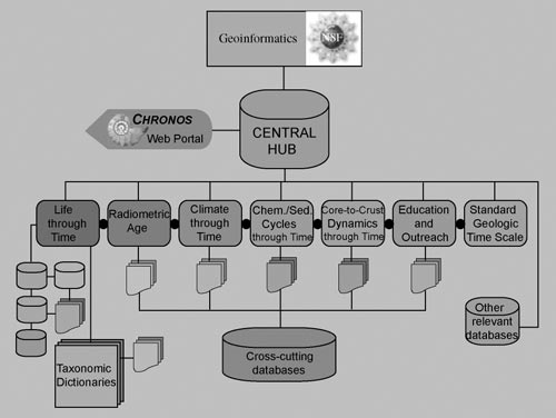 |
Figure 1. Schematic of the distributed CHRONOS system. |
The implementation of CHRONOS will involve the following tasks:
The four time-slice studies address longstanding scientific questions of societal relevance and interest (Cambrian life explosion, Permian-Triassic catastrophic extinctions, middle Cretaceous super-greenhouse world, and middle Miocene climate transitions; see fig. 2). Each involves different types and qualities of data and will improve and refine marine and continental data correlations at the global scale. The ultimate goal is for all geoscientists to be able to apply the CHRONOS system of integrated databases for deciphering the complex interactions of the Earth system through all of geologic time.
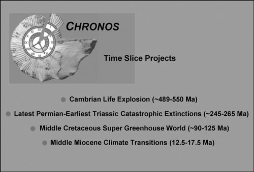 |
Figure 2. Time Slice Projects of CHRONOS. |
HOW THE CHRONOS INTERACTIVE NETWORKWILL WORK WITH DMTAND THE U.S STATE SURVEYS
An example of how CHRONOS will support the goals of the Digital Mapping Techniques workshops is the seamless way it will relate local state geological survey time scales to the International Time Scale. Initial information and links for both local and international scales will be available from the National Geologic Map Database’s Geological Names Lexicon (“GEOLEX”, http://ngmsvr.wr.usgs.gov/Geolex/). The current international scale is available from the International Commission on Stratigraphy (ICS, http://www.micropress.org/stratigraphy/index.htm) or a slightly modified version (retaining the Tertiary) from the U. S. Geological Survey (USGS), soon to be available on GEOLEX (fig. 3).
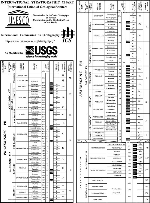 |
|
Figure 3. International Stratigraphic Chart as modified by USGS. PRINT a hgh-quality PDF version of this figure. |
As an example of how CHRONOS will function, let us imagine that we want to know where the currently internationally-defined Carboniferous-Permian boundary falls in the sections in Kansas and West Texas and how it relates to the boundary recognized by those states. From the CHRONOS portal, you would be linked to the ICS site containing the Global Stratotype Section and Points (GSSP’s) for all formally accepted boundaries of the ICS (currently, go to http://www.micropress.org/stratigraphy/index.htm, and select “GSSP’s”). The Carboniferous-Permian boundary information displayed is as follows:
| base Asselian Stage, base Cisuralian Series, base Permian System | Conodont, lowest occurrence of Streptognathodus isolatus within the S. “wabaunsensis” conodont chronocline. 6 m higher is lowest fusilinid foraminifer Sphaeroschwagerina | 27 m above base of Bed 19, Aidaralash Creek, Aktöbe, southern Ural Mountains, northern Kazakhstan | Ratified, 1996 | Episodes 21 (1), p.11 |
The first box leads to: http://www.micropress.org/stratigraphy/carper.htm where we find full references and section and map; the Episodes article also is available digitally.
From a completely different source identified
by CHRONOS, we would get a current reinterpretation
of the conodont lineages from the GSSP (http://www.kgs.ukans.edu/,
fig. 4), as found in Wardlaw and others (2003). From
the same publication, the conodont ranges from Kansas
are shown (fig. 5). A brief history of the placement
of the Permian boundary in Kansas would be available
from Paleodata (the National Geologic Map Database’s
National Paleontologic Database, fig. 6) which will
show where R. C. Moore placed the boundary at the
top of the Brownville Limestone, which became the
“traditional” boundary; and where the
boundary was modified using the first occurrence of
the Streptognathodus constrictus conodont zone
(an early contender for the boundary definition) placed
by Baars and others (1994) at the base of the Neva
Limestone. However, Boardman and others (1998) clearly
show the first occurrence of S. constrictus
and other species that make up the zone in the underlying
Burr Limestone. The first occurrence of S. isolatus
(the international boundary indicator) is in the Bennett
Shale of the Red Eagle Limestone.
 |
Figure 4. Interpretation of Streptognathodus conodont lineages from the GSSP of the Permian at Aidaralash Creek, Kazakhstan; section shown as numbered beds (from Wardlaw and others, 2003). |
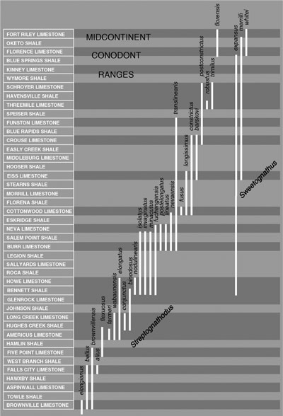 |
Figure 5. Ranges of conodont species in the Kansas section; darker intervals reflect largely marine deposition, lighter intervals reflect largely non- or marginal marine deposition (from Wardlaw and others, 2003) |
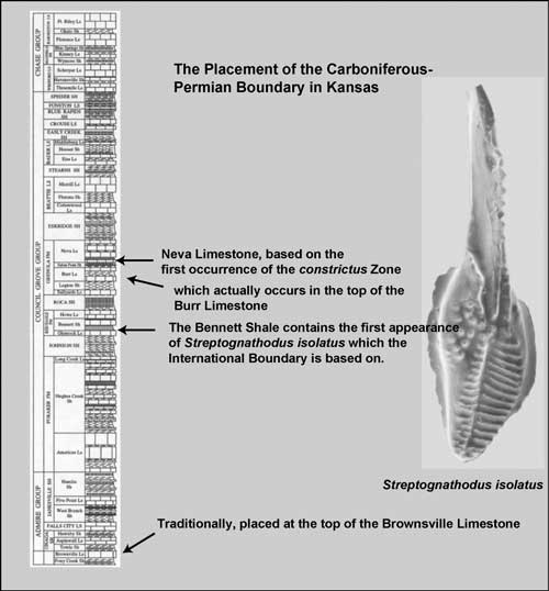 |
Figure 6. Historical Permian boundary placement in the Kansas section. |
Further, in the reference section for the Carboniferous-Permian boundary at Usolka in the Urals, Russia, there are found volcanic tuffs centimeters below and above the first occurrence of Streptognathodus isolatus that yield abundant zircons (Permophiles no. 39, http://pri.boisestate.edu/permophiles/issue39.pdf). Both horizons indicate virtually the same date, and though preliminary, are dated at 299 million years before present(Ma). This provides a solid age that can be applied to both Kansas and West Texas sections. Again, from the ICS website, information on relevant radiometric dates utilized in constructing the Phanerozoic time scale is available (fig. 7, from Gradstein and Ogg, 2004, to be made available through ICS).
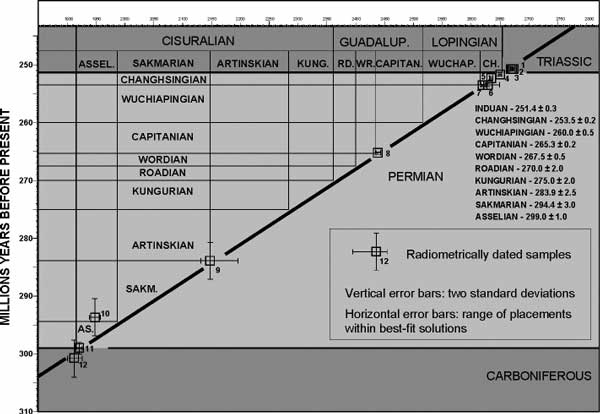 |
| Figure 7. Graphical correlation of radiometric ages and stage boundaries of the Permian. |
For the necessary stratigraphic information for West Texas, we would be linked to a digital copy of an article from Permophiles issue number 36 (June, 2000, http://pri.boisestate.edu/permophiles/issue36.pdf) which follows:
|
“Preliminary Placement of the International Permian Working Standard to the Glass Mountains, Texas” Bruce R. Wardlaw, U.S. Geological Survey,
Reston, VA The International Lower Permian Working Standard is based on the conodont distributions in the southern Urals, Kansas, and West Texas. Asselian is defined on the first appearance of Streptognathodus isolatus. This occurs at the base of the Bennett Shale of the Red Eagle Limestone in Kansas. The current working definition for the base of the Sakmarian is the First Appearance (FA) of Streptognathodus barskovi (sensu strictu). This occurs in the Eiss Limestone of the Bader Limestone in Kansas and is very close to the FA of Sweetognathus merrilli in the upper part of the Eiss. The working definition of the base of the Artinskian is the FA of S. florensis or Sweetognthus whitei, which both first appear in the base of the Florence Limestone of the Barnston Formation in Kansas. After Barneston deposition the Kansas section remains very shallow during marine incursions and only sparse to common Sweetognathus or Rabegnathus faunas are recovered. The working standard for Kungurian conodont zonation is based on the distribution of conodonts from the Glass Mountains, Texas. The working definition of the base of the Kungurian is the FA of Neostreptognathodus “exsculptus”. The Grey Limestone Member of the Gaptank Formation is a shallow-water carbonate that forms the top of the formation. Conodont faunas are sparse, but the base of the Grey Limestone Member contains a conodont fauna that correlates to the Foraker Limestone with the overlap of the ending range of Streptognathodus brownvillensis and S. elongatus. The top of the Grey Limestone contains a conodont fauna that correlates to the Grenola Limestone with Streptognathodus nevaensis and S. elongatus. Therefore, the Carboniferous-Permian boundary is located within the Grey Limestone.
The Neal Ranch Formation is dominated by prodelta siltstones with common plant debris and limestone and limestone conglomerate interbeds. The limestones yield a fair conodont fauna. At 52 m above the base Streptognathodus barskovi, S. isolatus and Sweetongnathus merrilli occur (equivalent to bed 12 of Ross, 1963). The overlap of barskovi and isolatus indicates the base of the S. barskovi zone. Streptognathodus barskovi occurs higher at 71 m where it occurs with S. postconstrictus which indicates the upper part of its zone. The Lenox Hills Formation is largely delta conglomerates and does not yield conodonts. However, in the Dugout Mountain area, it contains common limestone which yields a sparse fauna of Sweetognathus whitei and Neostreptognathodus transitus. This fauna indicates the upper Artinskian. Conodonts do not well constrain the Sakmarian-Artinskian boundary. The Skinner Ranch formation is largely limestone and limestone conglomerate with abundant conodont fuanas. In its type section it contains Neostreptognathodus pequopensis at its base. At 17 m, a plethora of species of Mesogondolella and Streptognathodus occur, including Neostreptognathodus “exsculptus” which marks the base of the Kungurian.” |
Since publication of that article, the working definitions have been refined and changed to formal proposals, and the definition of the Sakmarian has changed from the First Appearance Datum (FAD) of Streptognathodus barskovi to the FAD of Sweetognathus merrilli (Permophiles no. 41, http://pri.boisestate.edu/permophiles/issue41.pdf)
We want more substantial information, so CHRONOS would conduct an author search for Wardlaw and for Davydov, and find that there is no further information published by these authors on the placement of conodonts in the lower part of the West Texas regional stratotype. However, in our author search, we find all of Wardlaw’s field information is available via PaleoStrat (https://www.paleostrat.com), a paleontologic and stratigraphic information system that allows us to see the measured section (fig. 8), information on each sample, and the conodont faunas recovered and digital images of the representative specimens. Thus, we are assured of the placement of the Carboniferous-Permian boundary in the Wolfcamp Hills/Geologist Canyon section, the regional stratotype of the Wolfcampian.
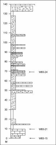 |
Figure 8. Columnar section of Wolfcamp Hills/Geologist Canyon section of Wardlaw and others (2003), and position of significant conodont samples. Measured in 1983 and recollected in 1984 (from PaleoStrat, definition of horizontal scale based on grain size also in PaleoStrat). |
CHRONOS will bring all this disparate information together for the user. The sources of information also will be accessible, so that additional ideas and questions can be posed by the user.
ACKNOWLEDGMENTS
Much of the description of CHRONOS comes from the interaction of the Steering Committee and their work on writing the NSF proposal (see http://www.CHRONOS.org). The author was only one of many participants and is indebted to all of CHRONOS’ creators. The author is solely responsible for the time scale interpretations. I thank David Soller for a rigorous review of the article.
REFERENCES
Baars, D. L., Ross, C. A, Ritter, S. M., and Maples, C. G., 1994, Proposed repositioning of the Pennsylvanian-Permian boundary in Kansas, in Baars, D. L., compiler, Revision of stratigraphic nomenclature in Kansas: Kansas Geological Survey Bulletin 230, p. 5–10.
Boardman, D. R., II, Nestell, M. K., and Wardlaw, B. R., 1998, Uppermost Carboniferous and lowermost Permian deposition and conodont biostratigraphy of Kansas, USA, in Jin, Y. G., Wardlaw, B. R., and Wang, Yue, eds., Permian stratigraphy, environments and resources, vol. 2, Stratigraphy and environments: Palaeoworld, no. 9, p. 19–32.
Gradstein, F. M., and Ogg, J. G., editors, 2004, A geologic time scale 2004: Cambridge University Press (in press).
Ross, C.A., 1963, Standard Wolfcampian Series (Permian), Glass Mountains, Texas: Geological Society of America Memoir 88, 205 p.
Wardlaw, B. R., Boardman, D. R., II, and Nestell, M. K., 2003, Conodont biostratigraphy of the uppermost Carboniferous and Lower Permian of Kansas: Kansas Geological Survey Bulletin (in press).