

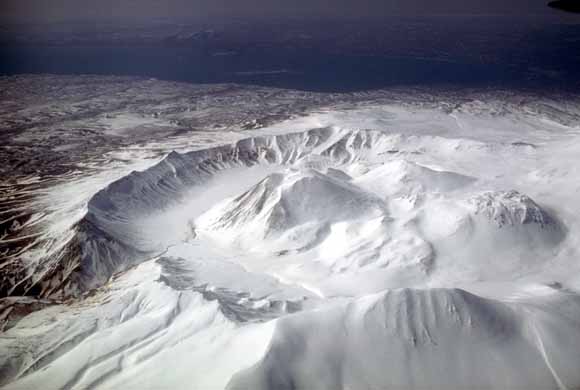
Aerial view, looking southwest, of Ugashik caldera adjacent to Peulik volcano. Photograph by Betsy Yount, U.S. Geological Survey, April 11, 1984
|
The Ugashik-Mount Peulik volcanic center, 550 km southwest of Anchorage on the Alaska Peninsula, consists of the late Quaternary 5-km-wide Ugashik caldera and the stratovolcano Mount Peulik built on the north flank of Ugashik. The center has been the site of explosive volcanism including a caldera-forming eruption and post-caldera dome-destructive activity. Mount Peulik has been formed entirely in Holocene time and erupted in 1814 and 1845. A large lava dome occupies the summit crater, which is breached to the west. A smaller dome is perched high on the southeast flank of the cone. Pyroclastic-flow deposits form aprons below both domes. One or more sector-collapse events occurred early in the formation of Mount Peulik volcano resulting in a large area of debris-avalanche deposits on the volcano's northwest flank. The Ugashik-Mount Peulik center is a calcalkaline suite of basalt, andesite, dacite, and rhyolite, ranging in SiO2 content from 51 to 72 percent. The Ugashik-Mount Peulik magmas appear to be co-genetic in a broad sense and their compositional variation has probably resulted from a combination of fractional crystallization and magma-mixing. The most likely scenario for a future eruption is that one or more of the summit domes on Mount Peulik are destroyed as new magma rises to the surface. Debris avalanches and pyroclastic flows may then move down the west and, less likely, east flanks of the volcano for distances of 10 km or more. A new lava dome or series of domes would be expected to form either during or within some few years after the explosive disruption of the previous dome. This cycle of dome disruption, pyroclastic flow generation, and new dome formation could be repeated several times in a single eruption. The volcano poses little direct threat to human population as the area is sparsely populated. The most serious hazard is the effect of airborne volcanic ash on aircraft since Mount Peulik sits astride heavily traveled air routes connecting the U.S. and Europe to Asia. Activity of the type described could produce eruption columns to heights of 15 km and result in significant amounts of ash 250-300 km downwind. |
Download the text portion of this report as a PDF document (1.7 MB)
Download Plate 1 of this report as a PDF document (660 KB)
Download Plate 2 of this report as a PDF document (148 KB)
For questions about the content of this report, contact Tom Miller
| Help
| PDF help
| Publications main page | Open-File
Reports for 2004 |