Link to USGS home page Link to USGS home page
Coastal and Marine Geology Program
Coastal & Marine Geology Program > South Carolina Coastal Erosion Study > Open File Report 2004-1013

Maps Showing the Stratigraphic Framework of South Carolina's Long Bay from Little River to Winyah Bay

USGS Open File Report 2004-1013

by: Wayne E. Baldwin, Robert A. Morton, Jane F. Denny, Shawn V. Dadisman, William C. Schwab, Paul T. Gayes, and Neal W. Driscoll

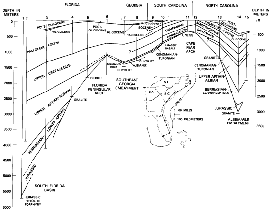
Figure 3. Generalized stratigraphic cross-section along the modern coast line from Florida to North Carolina. Adapted from Plate 9 of Maher and Applin (1971) using data in Applin and Applin (1965), Brown and others (1972), Gohn and Others (1977), Valentine (1979), and Applegate and others (1981). The names of the numbered wells are: 1. Bass Enter-Pumpkin Bay; 2. Humble-Collier #1; 3. Humble-Tucson #1; 4. Humble-Carroll #1; 5. Sun Oil-Powell Land #1; 6. Humble-Foremost #1; 7. California-Buie #1; 8. Larue-Jelks and Rodgers #1; 9. U.S.-Parris Island #2; 10. USGS-Clubhouse Crossroads #1; 11. USGS-Brittons Neck #1; 12. USGS-Calabash #1; 13. Karston-Laughton #1; 14. Standard Oil-Hatteras Light #1; a5. Stanard Oil - Esso #2 (from Gohn, 1988).
Printable version of Figure 3.Printable Version of Fig. 3 (203 KB PDF)
Can't see the printable PDF version? Get the free Adobe Acrobat® Reader.
Generalized stratigraphic cross-section along the modern coast line from Florida to North Carolina.

Coastal & Marine Geology Program > South Carolina Coastal Erosion Study > Open File Report 2004-1013


[an error occurred while processing this directive]