|
|
|
|
|
|
|
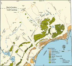
SettingSouth Carolina's Long Bay fronts approximately 100 km of the state's northeastern coast, known as the Grand Strand, located between the North Carolina border and the tidal estuary of Winyah Bay (Figure 2). In general, the vertical stratigraphic sequence landward of the study area consists of indurated to unconsolidated Cretaceous, Tertiary and Quaternary sedimentary units. Table 1 (Colquhoun and Muthig, 1991; Colquhoun and others, 1991) summarizes the names and estimated ages of formations mapped within the Lower Coastal Plain, including Horry and Georgetown Counties. Hayes (1994) describes the coastal compartment from Bogue Inlet, North Carolina (located just south of Cape Fear) to Debidue Island, South Carolina as consisting of predominantly wave-dominated, welded barrier islands and barrier spits, interrupted by segments of Pleistocene mainland beach. Several small tidal inlets and swashes separate these beaches and barriers, providing localized drainage for adjacent upland areas. Seaward, the inner continental shelf is low relief and largely sediment-limited, covered by a patchy and discontinuous sand sheet. Where sediment comprising the sand sheet is relatively thick (2 - 6 m) it has been reworked into bedforms of varying scale. In other locations the sand sheet is absent, exposing underlying Cretaceous/Tertiary strata and paleochannel fill at the seafloor (Wright and others, 1999; Ojeda and others, 2001; Baldwin, 2002). This coastal configuration is largely the result of regional tectonics, eustacy, and modern coastal processes. Table 1. Table of Cretaceous to Holocene Formations identified within the northeastern South Carolina Coastal Plain. Modified from Colquhoun and others, 1991 (Pliocene and younger units), and Colquhoun and Muthig, 1991 (Eocene and older units). [Download a 44 KB PDF version of Table 1].
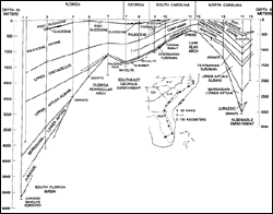
Limited sediment supply has played an important role in the evolution of the area since the late-Cretaceous/early-Paleocene, when uplift of the Cape Fear Arch (CFA), or Mid-Carolina Platform High (MCPH, Riggs and others, 1985; Riggs and Belknap, 1988) was initiated (Colquhoun and others, 1983; Sohl and Owens, 1991, Figure 2). Uplift of this post-rift structural feature has effectively diverted large volumes of Cenozoic sediment into the adjacent Albemarle and Southeast Georgia embayments (Colquhoun and others, 1983, Owens and Gohn, 1985; Gohn, 1988, Figure 2). A stratigraphic cross-section of the Atlantic Southeastern Lower Coastal Plain illustrates the absence of Cenozoic sediment overlying the CFA/MCPH and a gradual thickening of Cenozoic sediment with distance from its axis (Gohn, 1988, Figure 3).
Historically, the major source of sediment to Long Bay has been via Piedmont and coastal plain draining rivers (Figures 2 and 4), which deliver large quantities of sediment, primarily derived from the Appalachian Mountains and the Piedmont (Hayes, 1994). Fluctuation in sea level throughout the Pleistocene caused deposition of beach barrier complexes or "terraces" throughout the lower Coastal Plain (Colquhoun, 1965, 1968 and 1969; Colquhoun and others, 1972; Dubar and others, 1974 and 1980, Figure 4). These barriers diverted the rivers, generally parallel to the coastline. The Myrtle Beach barrier complex (Figure 4) caused significant diversion of the Pee Dee, Waccamaw and Black Rivers to the southernmost extent of Long Bay, where they now share a common confluence at Winyah Bay (Figures 2 and 4). Discharged sediment is now dominantly deposited within the Winyah Bay estuary, which appears to be an efficient sediment sink (Patchineelam and others, 1999).
Multiple phases of subaerial exposure and marine transgression, associated with fluctuations of sea level, have caused erosional truncation of the Cretaceous/Tertiary sedimentary units that underlie the inner continental shelf within Long Bay. These units crop out in areas where surficial sediment is absent. Without contribution from fluvial sediment sources, the Cretaceous and Tertiary continental shelf strata, and the deposits that comprise the mainland beaches and barriers, become the main source of sediment for the Long Bay sediment budget (Gayes, and others, 2003). Pleistocene transgressions and regressions have assisted in liberating sediment from these sources in the past, and storm events and day-to-day hydrodynamic processes continue to rework this material and incorporate it into the deposits and bedforms observed on the inner continental shelf (Pilkey, and others, 1981).
|