Link to USGS home page Link to USGS home page
Coastal and Marine Geology Program
Coastal & Marine Geology Program > Coastal Classification Mapping Project > Open File Report 2004-1044

Coastal Classification Atlas

Eastern Panhandle of Florida Coastal Classification Maps - Lighthouse Point to St. Andrew Bay Entrance Channel

USGS Open File Report 2004-1044

Robert A. Morton, Russell L. Peterson

Report Home Maps Overview Mapping Methods Coastal Classifications Geologic Setting Coastal Processes Coastal Vulnerability Classification Summary References

Eastern Panhandle of Florida Coastal Classification Maps

Index map for the Eastern Panhandle of Florida Coastal Classification Maps.
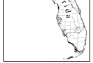
Index Map for Eastern Panhandle of Florida Coastal Classification Maps - Lighthouse Point to St. Andrew Bay Entrance Channel: This map shows the areas covered by the Coastal Classification Maps on this web site. Click on the location names or the outlined areas to view the map for that area. Florida location map.
One purpose of the USGS National Assessment of Coastal Change Project is to provide accurate representations of pre-storm ground conditions for areas that are designated high-priority because they have dense populations or valuable resources that are at potential risk from storm waves. Another purpose of the project is to develop a broad geomorphic coastal classification that, with only minor modification, can be applied to most coastal regions in the United States.

A Coastal Classification Map describing local geomorphic features is the first step toward determining the hazard vulnerability of an area. The Coastal Classification Maps of the National Assessment of Coastal Change Project present ground conditions such as beach width, dune elevations, overwash potential, and density of development. In order to complete a hazard vulnerability assessment, that information must be integrated with other information, such as prior storm impacts and beach stability. The Coastal Classification Maps provide much of the basic information for such an assessment and represent a critical component of a storm-impact forecasting capability.

The map above shows the areas covered by this web site. Click on any of the location names or outlines to view the Coastal Classification Map for that area.

Related Research Projects:

Coastal Classification Mapping Project
USGS Coastal & Marine Geology Program

Hurricane and Extreme Storm Impact Studies
USGS Coastal & Marine Geology Program

West-Central Florida Coastal Studies Project
USGS Coastal & Marine Geology Program

Related Links:

Coastal & Marine Geology Program
USGS

Center for Coastal & Watershed Studies
USGS


Beacon Hill NW Long Point SE/Crooked Island NE Long Point NW/SW Beacon Beach NE Beacon Beach NW Lighthouse Point NW/SW Lighthouse Point NW/SW St. Teresa SE St. Teresa SE St. Teresa SW St. Teresa SW McIntyre SE Dog Island NW Dog Island SW Carrabelle SE Carrabelle SE carrabelleSW Carrabelle SW/Sugar Hill NW Goose Island NE Goose Island NE/SE Goose Island NE/SE Goose Island SW Apalachacola SE Apalachicola SE/New Inlet NE New Inlet NW New Inlet NW Cape St. George NE Cape St. George NE West Pass SW/Cape St. George NW West Pass SW/Cape St. George NW Indian Pass SE Indian Pass SE Indian Pass SW Indian Pass SW Cape San Blas NE/SE Cape San Blas NE/SE Cape San Blas NW/SW Cape San Blas NW/SW St. Joseph Peninsula NE St. Joseph Point SE St. Joseph Point NE Overstreet SW Beacon Hill SE Beacon Hill NE Beacon Hill NW Long Point SE/Crooked Island NE Long Point NW/SW Beacon Beach NE Beacon Beach NW

Coastal & Marine Geology Program > Coastal Classification Mapping Project > Open File Report 2004-1044


[an error occurred while processing this directive]