The Padre Island National Seashore
Padre Island lies along the Gulf Coast of Texas and stretches 180 km (113 miles), which makes it the longest barrier island in the U.S. (Figure 1). A manmade channel divides Padre Island at Port Mansfield; otherwise the island would stretch uninterrupted from Corpus Christi to near Mexico. Mustang Island to the north is now connected to Padre Island due to the dredging of a ship channel at Aransas Pass (1880's), which resulted in the closure of Corpus Christi Pass. At its southern extent Padre Island is separated from Brazos Island by Brazos Santiago Pass. Padre Island is largely undeveloped because nearly 110 km (70 miles) of Padre Island (north of Port Mansfield channel) was established as a National Seashore in 1962 to preserve this pristine part of the Texas coast.
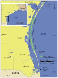 |
| Figure 1. Location of Padre Island National Seashore along the Gulf of Mexico coast in Texas.Click on figure for larger image. |
Padre Island National Seashore can be broken up into three distinct morphological environments. Northern Padre Island can be characterized as a gently sloping sand beach with moderate sized dunes. In the central part of the island the beaches are steeper and consist mostly of shell, and the foredunes are high and mostly continuous. Here strong winds pile sand into dunes as high as 15 meters (50 feet). The south end of Padre Island National Seashore is a sand and shell mix beach that generally lacks a dune ridge and overwashes frequently. This is due to higher rates of erosion and less vegetation to hold sand in place (Weise and White, 1980).
Storm impacts on coastal evolution along the south coast of Texas are too numerous to detail here, but a comprehensive overview of storms and tracks along the coast of Texas since the 16th century is hosted by the National Weather Service at http://www.srh.noaa.gov/lch/research/txhur.htm. This site emphasizes the impacts of Hurricane Bret (1999), which made landfall in Kenedy County and was responsible for between 12 to 20 overwashes within the National Seashore.