Interpretation:
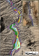
The sidescan-sonar mosaics were used to interpret the surficial geology
of the reservoir floor. This interpretation is based on the backscatter
intensity as well as the patterns of the backscatter. In this project,
high-backscatter values appear as light or white, while low-backscatter
values are black or dark gray. A complete description of the criteria
used to interpret the various features is presented in Foster
and others (2004). This report presents the polygon shapefile representing
that interpretation.
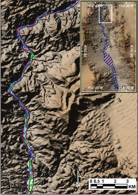
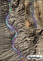
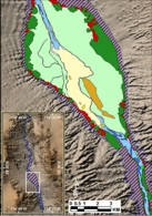
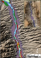
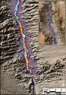
What follows is a series of images showing the interpretive layer of
Lake Mohave, working from north to south. Clicking on any image will open
a larger area of the same area. The legend for the interpretive layers
is available as a separate image and at the bottom of this page with a
more descriptive text.

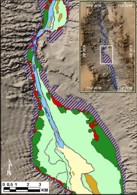
Interpretation definitions:
The following is a more detailed description of the sidescan interpretive
layer. The text in parentheses is the text contained in the INTERP attribute
of the shapefile. In this study, in referring to sidescan-sonar data,
high-backscatter is highly reflective data with pixel values towards white,
or a value of 255. Low-backscatter indicated low pixel values towards
black, or values of 0.
 alluvial (alluvial):
pre-impoundment alluvial fan deposits. The interpretation is based both
on the pre-impoundment topography and the sidescan-sonar imagery. The
imagery commonly shows a fine network of channels on the fan surfaces. alluvial (alluvial):
pre-impoundment alluvial fan deposits. The interpretation is based both
on the pre-impoundment topography and the sidescan-sonar imagery. The
imagery commonly shows a fine network of channels on the fan surfaces.
 bank (bank): steep
slope that shows as either high- or low-backscatter on the sidescan image.
Their location, in general, aligns with the edge of the pre-impoundment
Colorado River shown on the pre-dam topographic map. In general, the banks
are found off overbank and alluvial fan areas where there is unconsolidated
sediment that had been eroded by the river. By contrast, where rock cliffs
fringe the original river, there are no bank features. bank (bank): steep
slope that shows as either high- or low-backscatter on the sidescan image.
Their location, in general, aligns with the edge of the pre-impoundment
Colorado River shown on the pre-dam topographic map. In general, the banks
are found off overbank and alluvial fan areas where there is unconsolidated
sediment that had been eroded by the river. By contrast, where rock cliffs
fringe the original river, there are no bank features.
 high backscatter
channel (channel_high): high backscatter on the channel floor includes
areas with sidescan values between 180-254. In some places the backscatter
is uniformly high and smooth and probably represents gravel beds. In other
high backscatter places the return is more textured and may represent
areas of outcrop or widely spread cobbles or boulders. high backscatter
channel (channel_high): high backscatter on the channel floor includes
areas with sidescan values between 180-254. In some places the backscatter
is uniformly high and smooth and probably represents gravel beds. In other
high backscatter places the return is more textured and may represent
areas of outcrop or widely spread cobbles or boulders.
 low backscatter
channel (channel_low): low backscatter on the channel floor includes areas
with sidescan intensity values of 1-50. These areas usually occur along
the edges of the channel often downstream of promontories. These areas
are interpreted to represent mud deposits. low backscatter
channel (channel_low): low backscatter on the channel floor includes areas
with sidescan intensity values of 1-50. These areas usually occur along
the edges of the channel often downstream of promontories. These areas
are interpreted to represent mud deposits.
 moderate backscatter
channel (channel_moderate): moderate backscatter on the channel floor
includes areas with sidescan intensity values of 51-179. The backscatter
mostly is uniform, and is interpreted to represent sand. moderate backscatter
channel (channel_moderate): moderate backscatter on the channel floor
includes areas with sidescan intensity values of 51-179. The backscatter
mostly is uniform, and is interpreted to represent sand.
 dunes (dunes):
sub-aerial sand dunes. These look much like sand waves except that the
wavelength is longer and they are not located within the pre-impoundment
Colorado River. Instead, they are found adjacent to the river bed in low-relief
overbank areas. dunes (dunes):
sub-aerial sand dunes. These look much like sand waves except that the
wavelength is longer and they are not located within the pre-impoundment
Colorado River. Instead, they are found adjacent to the river bed in low-relief
overbank areas.
 low backscatter
post-impoundment (low bs): low backscatter areas on the sidescan image
that are not in the pre-impoundment Colorado River bed nor in areas identified
as overbank. The origin of these areas is unknown. low backscatter
post-impoundment (low bs): low backscatter areas on the sidescan image
that are not in the pre-impoundment Colorado River bed nor in areas identified
as overbank. The origin of these areas is unknown.
 moderate backscatter
post-impoundment (moderate): moderate backscatter areas on the sidescan
image occur outside the pre-impoundment river bed and do not have the
small channels that are characteristic of alluvial fan areas. In general
they appear to be smooth sandy slopes to either side of the river. moderate backscatter
post-impoundment (moderate): moderate backscatter areas on the sidescan
image occur outside the pre-impoundment river bed and do not have the
small channels that are characteristic of alluvial fan areas. In general
they appear to be smooth sandy slopes to either side of the river.
 mass-wasting deposit
(mw): mass-wasting deposits. These show on the sidescan image as high-backscatter
areas, which commonly have bright targets in them. Many of these deposits
are found off the mouths of washes, and are thought to represent debris
flow deposits associated with floods. Some, however, may just be small
alluvial fan deposits. Other mass-wasting deposits are found along the
base of rock cliffs. Which of these deposits post-date vs. predate the
formation of Lake Mohave is unknown. mass-wasting deposit
(mw): mass-wasting deposits. These show on the sidescan image as high-backscatter
areas, which commonly have bright targets in them. Many of these deposits
are found off the mouths of washes, and are thought to represent debris
flow deposits associated with floods. Some, however, may just be small
alluvial fan deposits. Other mass-wasting deposits are found along the
base of rock cliffs. Which of these deposits post-date vs. predate the
formation of Lake Mohave is unknown.
 overbank (overbank):
pre-impoundment overbank deposits occupy low-lying flat areas to either
side of the pre-impoundment Colorado River channel. These areas usually
are low-backscatter on the sidescan imagery often with high-backscatter
spots. The interpretation draws both on the sidescan imagery and the pre-dam
topography. The topography shows that these low-lying areas often were
populated with cottonwood trees. The white spots on the sidescan image
may be drowned trees, and the low-backscatter nature of the return may
be because the sediment is finger-grained. overbank (overbank):
pre-impoundment overbank deposits occupy low-lying flat areas to either
side of the pre-impoundment Colorado River channel. These areas usually
are low-backscatter on the sidescan imagery often with high-backscatter
spots. The interpretation draws both on the sidescan imagery and the pre-dam
topography. The topography shows that these low-lying areas often were
populated with cottonwood trees. The white spots on the sidescan image
may be drowned trees, and the low-backscatter nature of the return may
be because the sediment is finger-grained.
 rock (rock): high-backscatter
areas that coincide with steep cliffs on the pre-impoundment topography.
Some of these areas may be semi-consolidated sediment that has not collapsed
due to river undercutting prior to flooding of the area or to water saturation
subsequent to the filling of Lake Mohave. rock (rock): high-backscatter
areas that coincide with steep cliffs on the pre-impoundment topography.
Some of these areas may be semi-consolidated sediment that has not collapsed
due to river undercutting prior to flooding of the area or to water saturation
subsequent to the filling of Lake Mohave.
 reworked alluvial
fan deposit (rw_alluvial): reworked alluvial fan deposits. These deposits
are found in the former Colorado River channel off of alluvial fans. Usually
there is a scarp/bank that separates the alluvial fan from the alluvium
that has been reworked by the former river. These appear to be pre-impoundment
deposits. reworked alluvial
fan deposit (rw_alluvial): reworked alluvial fan deposits. These deposits
are found in the former Colorado River channel off of alluvial fans. Usually
there is a scarp/bank that separates the alluvial fan from the alluvium
that has been reworked by the former river. These appear to be pre-impoundment
deposits.
 sand waves (sw):
sand waves with wavelengths of 10-30 m. They are only found on the floor
of the pre-impoundment channel of the Colorado River, and are interpreted
to be fluvially generated bedforms that have been inactive since filling
of the reservoir. Sand waves mostly occur in areas of moderate backscatter. sand waves (sw):
sand waves with wavelengths of 10-30 m. They are only found on the floor
of the pre-impoundment channel of the Colorado River, and are interpreted
to be fluvially generated bedforms that have been inactive since filling
of the reservoir. Sand waves mostly occur in areas of moderate backscatter.
 large sand waves
(sw_large): sand waves with wavelengths of 100-450 m. They are only found
on the floor of the pre-impoundment channel of the Colorado River, and
are interpreted to be fluvially generated bedforms that have been inactive
since filling of the reservoir. Sand waves mostly occur in areas of moderate
backscatter. large sand waves
(sw_large): sand waves with wavelengths of 100-450 m. They are only found
on the floor of the pre-impoundment channel of the Colorado River, and
are interpreted to be fluvially generated bedforms that have been inactive
since filling of the reservoir. Sand waves mostly occur in areas of moderate
backscatter.
|