
![]()
Aeromagnetic Survey Index Map and Data Table of Maine and Gulf of Maine
![]()
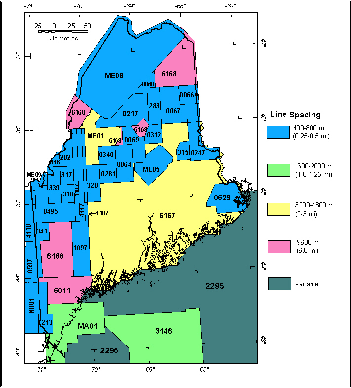
Maine Aeromagnetic Projects
| No* | Data Type | Survey Name | Flown By | Date Flown | Flight Spacing | Flight Dir | Flight Altitude | LineMi | Datum | Publication** |
| 0064 | A | Katahdin (Piscataquis) | USGS | 06/1951-07/1951 | 0.5 mi. | N-S | 500 AG |
1277
|
Total field, arbitrary datum | USGS GP-116 |
| 0066A | A | Aroostook North '50 1 | USGS | ?/1950 | 0.25 mi. | E-W | 500 AG |
1467
|
Total field, arbitrary datum | USGS GP-290, 291 |
| 0066B | A | Aroostook South '50 2 | USGS | ?/1950 | 0.25 mi. | E-W | 500 AG |
304
|
Total field, arbitrary datum | USGS GP-294, 295 |
| 0067 | A | Aroostook '51 | USGS | ?/1951 | 0.25mi | E-W | 500 AG |
2970 |
Total field, arbitrary datum | USGS GP-289, 290, 293-295 |
| 0068 | A | Devonian Belt 3 | USGS | 08/1954-09/1954 | 0.25-1 mi. | E-W | 500 AG |
3975
|
Total field, arbitrary datum | USGS GP-371-377 |
| 0069 | A | Katahdin '52 | USGS | 07/1952-08/1952 | 0.5 mi. | N-S | 500 AG |
1344
|
Total field, arbitrary datum | USGS GP-154, 155 |
| 0213 | A | Berwick '55 4 | USGS | 09/1955 | 0.5 mi. | E-W | 750 AG |
800
|
Total field, arbitrary datum | USGS GP-136, 137 |
| 0217 | A | Chamberlain | USGS | 09/1955 | 0.5 mi. | E-W | 500 AG |
2200
|
Total field, arbitrary datum | USGS GP-375-381 |
| 0247 | A | Danforth '56 | USGS | 07/1956 | 0.5 mi. | N-S | 500 AG |
550
|
Total field, arbitrary datum | USGS GP-423, 487 |
| 0249 | A | Oxbow '56 5 | USGS | 07/1956 | 0.25 mi. | E-W | 500 AG |
190
|
Total field, arbitrary datum | USGS GP-288, 289 |
| 0281 | A | Greenville | USGS | 08/1957 | 0.5 mi. | E-W | 500 AG |
1170
|
Total field, arbitrary datum | USGS GP-335 |
| 0282 | A | Attean | USGS | 08/1957-09/1957 | 0.25 mi. | N-S | 500 AG |
1150 |
Total field, arbitrary datum | USGS GP-310 |
| 0283 | A | Oxbow '57 6 | USGS | 08/1957-09/1957 | 0.25 mi | E-W | 500 AG |
2800 |
Total field, arbitrary datum | USGS GP-288, 292, 381 |
| 0284 | A | Danforth '57 7 | USGS | 08/1957 | 0.5 mi. | N-S | 500 AG |
1650 |
Total field, arbitrary datum | USGS GP-423 |
| 0312 | A | Staceyville-Katahdin | USGS | 08/1958-09/1958 | 0.25 mi | N-S | 500 AG |
1000 |
Total field, arbitrary datum | USGS GP-336 |
| 0313 | A | Bridgewater East 8 | USGS | 08/1958-09/1958 | 0.5 mi | N-S | 500 AG |
190 |
Total field, arbitrary datum | USGS GP-291 |
| 0314 | A | Smyra Mills East 2 | USGS | 08/1958-09/1958 | 0.5 mi | E-W | 500 AG |
105 |
Total field, arbitrary datum | USGS GP-293, 294 |
| 0315 | A | Danforth Anomaly | USGS | 08/1958-09/1958 | 0.5 mi | N-S | 500 AG |
355 |
Total field, arbitrary datum | USGS GP-423 |
| 0316 | A | Skinner | USGS | 09/1958 | 0.25 mi | E-W | 750 AG | 280 | Total field, arbitrary datum | USGS GP-310 |
| 0317 | A | Spencer | USGS | 09/1958 | 0.25 mi | N-S | 750 AG | 850 | Total field, arbitrary datum | USGS GP-331 |
| 0318 | A | Stratton | USGS | 09/1958 | 0.25 mi | E-W | 750 AG | 850 | Total field, arbitrary datum | USGS GP-333 |
| 0320 | A | Bingham-The Forks | USGS | 09/1958 | 0.25 mi | N-S | 750 AG | 1660 | Total field, arbitrary datum | USGS GP-485,499 |
| 0339 | A | Kennebago-Chain Lakes | USGS | 09/1959 | 0.5 mi. | N-S | 3500 B | 1140 | Total field, arbitrary datum | USGS GP-330, 332 |
| 0340 | A | Moosehead Lake | USGS | 09/1959-10/1959 | 0.25 mi. | N-S | 500 AG | 1015 | Total field, arbitrary datum | USGS GP-334 |
| 0341 | A | Old Speck Mountain | USGS | 09/1959-10/1959 | 0.5 mi | N-S | 3500 B | 500 | Total field, arbitrary datum | USGS GP-486 |
| 0494 | A | Oquossoc11 | USGS | 08/1962 | 0.5 mi | N-S | 3500 B | 860 | Total field, arbitrary datum | USGS GP-477, 478 |
| 0495 | A | Saddleback | USGS | 08/1962 | 0.5 mi | N-S | 3500 B | 860 | Total field, arbitrary datum | USGS GP-479, 480 |
| 0597 | A | North-central N.H. '66 | USGS | 12/1966 | 0.5 mi | E-W | 5500 B | 1800 | Total field, arbitrary datum | USGS GP-891 |
| 0629 | A | Eastport-Calais | USGS | 12/1966 | 0.5 mi | E-W | 400 AG | 1235 | IGRF65 | USGS OF99-0557 |
| 0642 | A | Central N.H. '68 | USGS | 07/1968 | 0.5 mi | E-W | 5000 B | 970 | Total field, arbitrary datum | USGS GP-892 |
| 1097 | D | Sherbrooke-Lewiston '80 | USGS | 11/1980 | 0.5 mi | N-S | 300 AG | 2174 | IGRF80 | Bothner and others (1985) |
| 1107A | D | Sherbrooke-Lewiston- Lines E | USGS | 09/1981 | 0.5 mi | N-S | 300 AG | 360 | IGRF80 | Bothner and others (1985) |
| 1107B | D | Sherbrooke-Lewiston- Lines W | USGS | 09/1981 | 0.5 mi | N-S | 300 AG | 900 | IGRF80 | Bothner and others (1985) |
| 2295 | Grid | Gulf of Maine | several | several | variable | variable | variable | ? | ? | Macnab and others, 1990 |
| 3146 | D | Gulf of Maine | Aero | 11/78-12/78 | 1.25 mi | N-S | 2500 B | 7500 | IGRF75 | USGS OFR79-1198 |
| 4117 | D | Maine Profiles | QEB | ?/1982 | 0.5 mi | N-S | 500 AG | 1121 | IGRF80 | Bothner and others (1985) |
| 4118 | D | Sherbrooke-Lewiston '82 | QEB | 10/1982 | 0.5 mi | E-W | 500 AG | 7360 | IGRF80 | Bothner and others (1985) |
| 6011 | D | New England - NURE | Texas Inst. | 09/1975-11/1975 | 6 mi | E-W | 400 AG | 7850 | ? | Texas Instruments (1976) |
| 6167 | D | Southeastern Maine - NURE | Carson | 06/1980-11/1980 | 3 mi | E-W | 400 AG | 4235 | IGRF75 | NGDC, 1999 |
| 6168 | D | Maine - NURE | Carson | 06/1980-11/1980 | 6 mi | E-W | 400 AG | 5736 | IGRF75 | NGDC, 1999 |
| MA01 | A | Western Gulf of Maine (BE-A2) | Aero Service | 9/1975-11/1975 | 1 mi | N-S | 1500 B | 7850 | IGRF65 | Weston Geophysical Research, 1976 |
| ME01 | A | Western Maine 9 | Aero | 05/1948 | 2 mi | NW-SE | 1000 AG | 1200 | Total field, arbitrary datum | Hurley & Thompson (1950) |
| ME05 | A | Central Maine | Sewall | 05/1959-07/1959 | 0.5 mi | NW-SE | 500 AG |
1570 |
Total field, arbitrary datum | Wing (1959); Bond (1993b) |
| ME08 | A | Northwest Maine | Lockwood | ?/1966 | 0.5 mi | NW-SE | 1000 AG |
8100 |
? | Bond (1993a) |
| ME09 | A | Arnold Pond Area | ? | ? | ? | N-S | ? | ? | ? | USGS GP-312 |
| ME10 | A | Forest City-Meddybemps 10 | ? | 1953? | 0.5 mi | E-W | 500 AG |
500 |
IGRF65 | USGS OF72-459 |
| NH01 | A | Central New Hampshire (BE-B1) | Aero | 06/1976-10/1976 | 0.5 mi. | N-S | 3000 B |
6869
|
IGRF65 | Weston Geophysical Research, 1976 |
Description of Table Columns:
No.: Internal USGS project identification number
Data Type: Data collected as: A=Analog, D=Digital
Survey Name: Internal project name (not always the
name used in publication title)
Flown By: Company or government agency who
flew the original survey
Flight Spacing and Flight Dir.: Primary
flight-line spacing and primary flight-line direction
Flight Altitude: Flight altitude in feet; B =
barometric elevation, AG = above ground draped over topography
LineMi.: Approximate total of line miles
flown for this survey
Datum: Indicates if a regional field was removed
and, if it could be determined, the base value removed. Total field = no
regional was removed. Arbitrary datum = the base value removed was not
stated on the map.
Publication: Brief publication reference**.
USGS paper contour map publications are for analog surveys. Geophysical
Investigations Maps = GP-yyyy, Open-file Maps = yy-zzz, Miscellaneous
Field Investigations= MF-zzz, refers to all or part of the original project
area.
* Files of most digitized analog contour maps may be downloaded from the USGS site: http://pubs.usgs.gov/of/1999/ofr-99-0557/html/mag_home.htm (U.S. Geological Survey, 1999)
** For more complete references see Hill (1991).
|| Top || Page 1 || Compilation || Processing || Index Maps || State Magnetic Maps || Gravity Map || Download data || References ||
USGS Links - || USGS - Eastern Minerals Team || USGS - Geology Discipline || USGS - Home Page ||
[an error occurred while processing this directive]