The Kenai Fjords National Park
The rocky, cliffed coast of Kenai Fjords National Park lies along the southeastern side of the Kenai Peninsula in south-central Alaska (fig. 2). This region of the Kenai Peninsula is part of the Chugach terrane that collided with Alaska about 65 million years ago; the bedrock is primarily composed of partially metamorphosed muddy sandstones and shales from turbidite deposit with intrusions of granite and granodiorite (Beikman, 1980) (fig. 3A) The Harding Icefield sits astride the Kenai Mountains and supplies ice to outlet glaciers that carve deep U-shaped valleys into the soft bedrock (fig. 2). For more information on the geology of south-central Alaska please see the following:
http://www.alaskageography.com/maps/maps.htm.
In addition to the tectonic activity associated with accreting terranes along south-central Alaska, the advance and retreat of glacier ice throughout the Pleistocene Epoch (fig. 3B) has caused significant sea-level fluctuations along the coast of the Gulf of Alaska. Alpine glaciers may have appeared in the mountains of south-central Alaska between 10 and 13 million years ago and many of these areas have remained ice covered for at least the past five million years (Connor and O'Haire, 1988). Deep valleys carved by glaciers during glacial maxima are now flooded creating irregular shorelines such as Kenai Fjords National Park. Presently, waves and tides further modify this glacier-eroded coastline creating a variety of geomorphologic features along the coast including sand and gravel pocket beaches, tidewater glaciers, rock cliffs, mud flats, and sea arches and stacks.
The affects of climate change on glaciers and icefields are a primary concern for Kenai Fjords NP. Because the focus of this project is potential change to the shoreline of Kenai Fjords NP with regard to changing sea level, the change in glacier ice is not considered unless the glacier terminus calves in the ocean (tidewater glacier). Change in the Harding Icefield and changes in glacier area and termini within the park are discussed in Hall and others (2005). Changes in outlet glacier termini and volume are discussed in Adalgeirsdottir and others (1998). Additional information on a variety of climate change impacts and hazards in Alaska and the Arctic is found in ACIA (2005).
Other hazards that can result in immediate and major coastal and sea-level change along Kenai Peninsula include earthquakes, tsunamis, and landslides. In 1964, a magnitude 9.2 earthquake shook south-central Alaska and resulted in six feet of coseismic land subsidence along the Kenai Fjords NP coastline (Plafker, 1971). However, in the decades (1964 - 1995) following the earthquake, the Kenai Fjords NP shoreline is estimated to have experienced between 20 and 40 cm of post-seismic tectonic uplift (fig. 4). Uplift rates have been determined from GPS measurements and water level recorders (Cohen and Freymueller, 1997; Cohen and Freymueller, 2001). Most areas on Kenai Peninsula (including Kenai Fjords NP) are emerging at a rate faster than the rise of eustatic (global) sea-level (1.8 mm/yr), which is unique when compared to most of the world's coastline (fig. 1).
Nearly 25 years after the 1964 Good Friday Earthquake, a major environmental accident affected south-central Alaska. On 24 March 1989 the 300-m (987-foot) long supertanker Exxon Valdez grounded on Bligh Reef in Prince William Sound spilling nearly 11 million gallons of crude oil and impacting more than 1,100 miles of pristine shoreline. The coastal impacts of such an incident are still being determined, because it is the largest oil spill in U.S. history and the long-term affects are still uncertain. Additional information on the 1989 Exxon Valdez oil spill in Prince William Sound can be found at the following:
http://oceanservice.noaa.gov/education/stories/oilymess/welcome.html
| Click on figure for larger image.
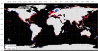 |
Figure 1. Global distribution of water-level recording stations as reported by the Permanent Service for Mean Sea Level (PSMSL, 2005).
|
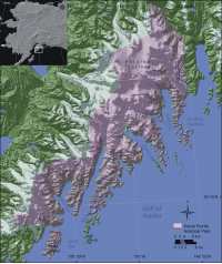 |
Figure 2. Index map of Kenai Fjords National Park, Alaska.
|
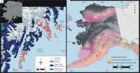 |
Figure 3. Extent of Pleistocene glaciations and present-day glaciers in Alaska.
|
 |
Figure 4. Regional cumulative post-seismic uplift from GPS measurements and tide gauges as determined by Cohen and Freymueller: 1964-1995.
|
|